Martial Arts Stadium metro station
Martial Arts Stadium is a station on the Orange line of Kaohsiung MRT in Lingya District, Kaohsiung, Taiwan.
Martial Arts Stadium O9 技擊館 | |||||||||||
|---|---|---|---|---|---|---|---|---|---|---|---|
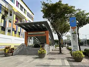
 Exit 4 of Martial Arts Stadium station | |||||||||||
| General information | |||||||||||
| Location | Lingya, Kaohsiung Taiwan | ||||||||||
| Operated by | |||||||||||
| Line(s) |
| ||||||||||
| Platforms | One island platform | ||||||||||
| Connections | Bus stop | ||||||||||
| Construction | |||||||||||
| Structure type | Underground | ||||||||||
| Accessible | Yes | ||||||||||
| History | |||||||||||
| Opened | 2008-09-14 | ||||||||||
| Passengers | |||||||||||
| 3,059 daily (Jan. 2011)[1] | |||||||||||
| Services | |||||||||||
| |||||||||||
| Martial Arts Stadium metro station | |||||||||||||
|---|---|---|---|---|---|---|---|---|---|---|---|---|---|
| Traditional Chinese | 技擊館車站 | ||||||||||||
| Simplified Chinese | 技击馆车站 | ||||||||||||
| |||||||||||||
Station overview

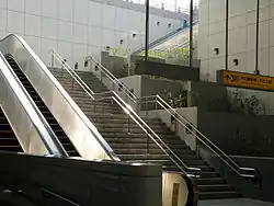
Exit 3 of Martial Arts Stadium station
The station is a two-level, underground station with an island platform and four exits.[2] The station is 201 meters long and is located on Jhongjheng 1st Rd across from Martial Art Stadium, other sporting facilities nearby include the Olympic Pool, Sports Stadium and Extreme Sports Arena.[3]
Station layout
| Street Level | Entrance/Exit | Entrance/Exit |
| B1 | Concourse | Lobby, information desk, automatic ticket machines, one-way faregates, restrooms (near exit 1) |
| B2 | Platform 1 | ← KMRT Orange Line toward Sizihwan (Wukuaicuo) |
| Island platform, doors will open on the left | ||
| Platform 2 | KMRT Orange Line toward Daliao (Weiwuying) → | |
Exits
- Exit 1: Jhongjheng 1st Rd., Furen Rd., Jhongjheng Elementary School, Martial Arts Stadium (west), Kaohsiung Japanese School, Kaohsiung Guandi Temple, Wumiao Market
- Exit 2: Jhongjheng 1st Rd., Mingde St., Kaohsiung Extreme Sports Ground, Fu'an Park, Kaohsiung City Local Office of Bureau of Labor Insurance
- Exit 3: Jhongjheng 1st Rd., Wuying Rd., Chungcheng Stadium, Sports Development Bureau, Kaohsiung City Government
- Exit 4: Jhongjheng 1st Rd., Martial Arts Stadium (east), Kaohsiung International Swimming Pool, Zhengdao Park
Around the station
- Jhongjheng Rd. Interchange, National Highway No. 1
- Chung Cheng Martial Arts Stadium
- Chungcheng Stadium
- Jhongjheng Park
- Kaohsiung Japanese School
References
Wikimedia Commons has media related to Martial Arts Stadium Station.
- "統計資訊 > 統計月報". Transportation Bureau, Kaohsiung City Government. Retrieved 2011-02-15.
- "技擊館站". 高雄捷運公司. Retrieved 2010-07-05.
- "技擊館站週邊地圖". 高雄捷運公司. Archived from the original on 2007-12-04. Retrieved 2010-07-05.
This article is issued from Wikipedia. The text is licensed under Creative Commons - Attribution - Sharealike. Additional terms may apply for the media files.