Martinsdale Colony, Montana
Martinsdale Colony is a Hutterite community[3] and census-designated place (CDP) in Wheatland County, Montana, United States. It is on the western edge of the county, bordered to the west by Meagher County and 4 miles (6 km) northeast of the unincorporated community of Martinsdale. The Musselshell River forms the southern edge of the CDP.
Martinsdale Colony, Montana | |
|---|---|
.jpg.webp) Martinsdale Colony | |
 Martinsdale Colony  Martinsdale Colony | |
| Coordinates: 46°29′23″N 110°16′2″W | |
| Country | United States |
| State | Montana |
| County | Wheatland |
| Area | |
| • Total | 2.22 sq mi (5.76 km2) |
| • Land | 2.22 sq mi (5.76 km2) |
| • Water | 0.00 sq mi (0.00 km2) |
| Elevation | 4,740 ft (1,440 m) |
| Population (2020) | |
| • Total | 97 |
| • Density | 43.63/sq mi (16.84/km2) |
| Time zone | UTC-7 (Mountain (MST)) |
| • Summer (DST) | UTC-6 (MDT) |
| ZIP Code | 59053 (Martinsdale) |
| Area code | 406 |
| FIPS code | 30-48190 |
| GNIS feature ID | 2804318[2] |
U.S. Route 12 runs through the southern part of the CDP, leading east 22 miles (35 km) to Harlowton, the Wheatland county seat, and west 36 miles (58 km) to White Sulphur Springs.
The community was first listed as a CDP prior to the 2020 census.[2]
Education
It is zoned to Harlowton Public Schools.[5]
References
- "ArcGIS REST Services Directory". United States Census Bureau. Retrieved September 5, 2022.
- "Martinsdale Colony Census Designated Place". Geographic Names Information System. United States Geological Survey, United States Department of the Interior.
- Morton, Claudette, ed. (2010). Essential Understandings of Montana Hutterites: A Resource for Educators and Students (PDF). Montana Office of Public Instruction. p. 2. Retrieved June 16, 2021.
- "Census of Population and Housing". Census.gov. Retrieved June 4, 2016.
- "2020 CENSUS - SCHOOL DISTRICT REFERENCE MAP: Wheatland County, MT" (PDF). U.S. Census Bureau. Retrieved October 7, 2022.
Municipalities and communities of Wheatland County, Montana, United States | ||
|---|---|---|
| Cities | 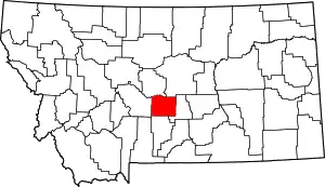 Wheatland County map | |
| CDPs | ||
This article is issued from Wikipedia. The text is licensed under Creative Commons - Attribution - Sharealike. Additional terms may apply for the media files.