Mary Peary Peaks
The Mary Peary Peaks (Danish: Mary Peary Tinder) are a mountain in the Roosevelt Range, Peary Land, Northern Greenland. Administratively they belong to the Northeast Greenland National Park.
| Mary Peary Peaks | |
|---|---|
| Mary Peary Tinder | |
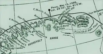 Robert Peary's 1903 Northern Greenland map section | |
| Highest point | |
| Elevation | 1,850 m (6,070 ft)[1] |
| Prominence | 503 m (1,650 ft)[1] |
| Listing | |
| Coordinates | 83°25′18″N 32°59′37″W[1] |
| Geography | |
 Mary Peary Peaks | |
| Parent range | Roosevelt Range |
| Climbing | |
| First ascent | No data[2] |
The peaks were named by Robert Peary after his mother, Mary Peary (1827 – 1900).[3] Peary saw the mountain from a distance, in the vicinity of Constable Bay, as he traveled along the shore. He marked it in his map but did not go inland to explore the features of the range.[4]
Geography
The Mary Peary Peaks are located in the middle sector of the Roosevelt Range east of the Polar Corridor in a roughly central position to the west of the western end of the H. H. Benedict Range.[5] The maximum height is 1,850 metres (6,070 ft).[1] According to the A-5 sheet of the Defense Mapping Agency Navigation chart it is a 6,200-foot-high (1,890 m) summit.[6]
The Sif Glacier originates in the ice cap of the Mary Peary Peaks. It flows in a WSW/ENE direction bifurcating south of the Birgit Koch Peaks with one arm flowing roughly northwards and another southwards.[7]
See also
References
- "Helvetia Tinde, Greenland". Peakbagger. Retrieved 25 November 2022.
- Longitude Zone High Points
- Daniel E. Harmon, Robert Peary. 2013
- Manliness and Exploration: The Discovery of the North Pole
- Google Maps
- 1,000,000 scale Operational Navigation Chart; Sheet A-5
- Arctic Report, 121