Matha, Charente-Maritime
Matha (French pronunciation: [mata]) is a commune in the Charente-Maritime department in southwestern France.
Matha | |
|---|---|
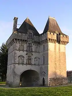 Chateau | |
 Coat of arms | |
Location of Matha | |
 Matha  Matha | |
| Coordinates: 45°52′06″N 0°19′08″W | |
| Country | France |
| Region | Nouvelle-Aquitaine |
| Department | Charente-Maritime |
| Arrondissement | Saint-Jean-d'Angély |
| Canton | Matha |
| Government | |
| • Mayor (2020–2026) | Wilfrid Hairie[1] |
| Area 1 | 19.08 km2 (7.37 sq mi) |
| Population | 2,178 |
| • Density | 110/km2 (300/sq mi) |
| Time zone | UTC+01:00 (CET) |
| • Summer (DST) | UTC+02:00 (CEST) |
| INSEE/Postal code | 17224 /17160 |
| Elevation | 23–68 m (75–223 ft) |
| 1 French Land Register data, which excludes lakes, ponds, glaciers > 1 km2 (0.386 sq mi or 247 acres) and river estuaries. | |
Population
In 1818 Matha absorbed the former commune of Saint-Hercé.[3]
|
| |||||||||||||||||||||||||||||||||||||||||||||||||||||||||||||||
| Source: EHESS[3] and INSEE (1968-2017)[4] | ||||||||||||||||||||||||||||||||||||||||||||||||||||||||||||||||
References
- "Répertoire national des élus: les maires" (in French). data.gouv.fr, Plateforme ouverte des données publiques françaises. 13 September 2022.
- "Populations légales 2020". The National Institute of Statistics and Economic Studies. 29 December 2022.
- Des villages de Cassini aux communes d'aujourd'hui: Commune data sheet Matha, EHESS (in French).
- Population en historique depuis 1968, INSEE
External links
 Media related to Matha at Wikimedia Commons
This article is issued from Wikipedia. The text is licensed under Creative Commons - Attribution - Sharealike. Additional terms may apply for the media files.