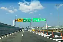
Matsubara Route
The Matsubara Route (松原線, Matsubara-sen), signed as Route 14, is one of the tolled routes of the Hanshin Expressway system serving the Keihanshin area in Kansai, Japan. It travels in a northwest to southeast direction from the Chūō ward of Osaka, beginning at a junction with the Loop Route, to a junction with the Hanwa Expressway, Kinki Expressway, and Nishi-Meihan Expressway in the city of Matsubara. The expressway has a total length of 12.1 kilometers (7.5 mi).
 阪神高速14号松原線 | |
|---|---|
The Matsubara Route highlighted in red | |
| Route information | |
| Maintained by Hanshin Expressway Company, Limited | |
| Length | 12.1 km (7.5 mi) |
| Existed | 1970–present |
| Major junctions | |
| North end | Ebisu Junction in Chūō-ku, Osaka |
| South end | Matsubara Junction in Matsubara |
| Location | |
| Country | Japan |
| Highway system | |
Route description

The Matsubara Route travels in a northwest to southeast direction from the Chūō ward of Osaka, beginning at a junction with the Loop Route, to a junction with the Hanwa Expressway, Kinki Expressway, and Nishi-Meihan Expressway in the city of Matsubara. Serving as the primary expressway route from central Osaka to Matsubara and points beyond in eastern Osaka Prefecture and Nara Prefecture, the highway winds its way through the wards of Osaka. Much of this section of the expressway lies above the Tanimachi Line of the Osaka Metro between Abeno Station and Kire-Uriwari Station. After crossing over the Yamato River into Matsubara, the expressway has a junction with Yamatogawa Route that parallels the river from the junction to its end near Osaka Bay. Before ending at the junction with the Hanwa Expressway, Kinki Expressway, and Nishi-Meihan Expressway, the expressway briefly crosses back into the city of Osaka before returning into Matsubara where the junction lies.[1] The expressway has a total length of 12.1 kilometers (7.5 mi).[2]
History
The first section of the expressway near the Loop Route was completed in 1970. The majority of the expressway was completed by 1980 after the opening of an 11.2-kilometer-long (7.0 mi) section.[3] A mini parking area once operated between Miyake and Matsubara junctions,[4] it has since been removed.[5] On 21 March 2013, the expressway was linked to the Yamatogawa Route at Miyake Junction.[6]
List of interchanges
The entire expressway lies within Osaka Prefecture.
| Location | km[2] | mi | Exit | Name | Destinations | Notes | |
|---|---|---|---|---|---|---|---|
| Osaka | 0.0 | 0.0 | – | Ebisu | Northern terminus | ||
| 0.6 | 0.37 | 14-01 | Tennōji | Unnamed city street – Tanimachi-9, Terada-chō, Harima-chō | Southbound exit only | ||
| 0.7 | 0.43 | 14-02 | Abeno | Abiko-suji | Northbound entrance only | ||
| 3.2 | 2.0 | 14-03 | Fuminosato | Abiko-suji – Tennōji Station, Nagai Park | Southbound entrance, northbound exit | ||
| 4.8 | 3.0 | 14-04 | Komagawa | Nankō-dōri – Hirano, Nagai Park | Southbound exit, northbound entrance | ||
| 6.9 | 4.3 | 14-05 | Hirano | Southbound entrance, northbound exit | |||
| 7.7 | 4.8 | 14-06 | Kire-Uriwari | Southbound exit, northbound entrance | |||
| 9.2 | 5.7 | – | Uriwari Toll Booth | Toll gate is for northbound traffic only | |||
| Matsubara | 9.5 | 5.9 | 14-07 | Miyake | Southbound exit, northbound entrance | ||
| 10.1 | 6.3 | – | Miyake | Southbound entrance, northbound exit | |||
| – | Miyake Mini Parking Area | Closed | |||||
| Osaka | 11.4 | 7.1 | 14-08 | Ōbori | Osaka Prefecture Route 179 | Southbound exit, northbound entrance | |
| Matsubara | 12.1 | 7.5 | – | Matsubara | Southern terminus; expressway continues as the Nishi-Meihan Expressway | ||
1.000 mi = 1.609 km; 1.000 km = 0.621 mi
| |||||||
See also
References
- "Expressway Map". Hanshin Expressway Company. Retrieved 17 November 2020.
- Google (11 November 2020). "Matsubara Route" (Map). Google Maps. Google. Retrieved 11 November 2020.
- "50年のあゆみ" [50 years of history] (in Japanese). Hanshin Expressway Company. 2013. Retrieved 11 November 2020.
- "三宅ミニパーキングエリア" [Miyake Mini Parking Area] (in Japanese). Hanshin Expressway Company. December 2005. Archived from the original on 12 December 2005. Retrieved 11 November 2020.
- "Hanshin Expressway parking area guide" (PDF) (in Japanese). Hanshin Expressway Company. June 2020. Retrieved 11 November 2020.
- "阪神高速6号大和川線の三宅西出入口〜三宅中区間が新しく開通しました" [Miyake-nishi entrance and the Miyake Naka section of the Route 6 of the Hanshin Expressway the Yamatogawa Route has been opened.] (in Japanese). Hanshin Expressway Company. 2016. Retrieved 25 November 2020.
External links
 Media related to Category:Hanshin Expressway Route 14 Matsubara Route at Wikimedia Commons