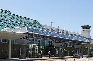
Matsuyama Airport
Matsuyama Airport (松山空港, Matsuyama kūkō) (IATA: MYJ, ICAO: RJOM) is an airport located 3 NM (5.6 km; 3.5 mi) west southwest[2] of Matsuyama, Ehime, Japan.
Matsuyama Airport 松山空港 Matsuyama kūkō | |||||||||||
|---|---|---|---|---|---|---|---|---|---|---|---|
 | |||||||||||
| Summary | |||||||||||
| Airport type | Public | ||||||||||
| Operator | Ministry of Land, Infrastructure, Transport and Tourism | ||||||||||
| Serves | Matsuyama | ||||||||||
| Elevation AMSL | 13 ft / 4 m | ||||||||||
| Coordinates | 33°49′38″N 132°41′59″E | ||||||||||
| Website | www.matsuyama-airport.co.jp | ||||||||||
| Map | |||||||||||
 RJOM Location in Ehime Prefecture  RJOM Location in Japan | |||||||||||
| Runways | |||||||||||
| |||||||||||
| Statistics (2015) | |||||||||||
| |||||||||||
Source: Japanese Ministry of Land, Infrastructure, Transport and Tourism[1] | |||||||||||
_2.jpg.webp)
History
The airport opened as an Imperial Japanese Navy airfield in 1941. At the end of the war it served as the base for the 353th Fighter Squadron which defended against B-29s' raid. The airport then became under the administration of the British Commonwealth Occupation Force and became a country-administered civil airport in 1952. During the Korean War, the airport was used by the US and British Military. It was the first airport in Shikoku to see jet service following a runway extension project in 1972.[3]
An office park named "Biz Port" opened near the airport in 2003 to attract technology businesses, but was scheduled to close on 1 April 2015.[4]
In 2013, the government of Ehime Prefecture and local business organizations announced that they would begin subsidizing the airport's international routes to Shanghai and Seoul, which had seen load factors of less than 50% in June 2013.[5]
All international service at the airport was suspended in 2020 due to the COVID-19 pandemic. International service resumed in December 2022 with a VietJet charter flight bringing tourists from Ho Chi Minh City.[6]
Charter flights between Matsuyama Airport and Taipei Songshan Airport were expected to be resumed in February 2023.[7]
Accidents and incidents
- On 13 November 1966, All Nippon Airways Flight 533 crashed in the sea just a few miles away from the airport, killing all 50 people on board. The cause was never determined. Because of this event, airport authorities across the country started planning runway extension projects and installation of aeronautical navigation systems including an ILS at every Japanese airport.
- On 26 October 2013, a small propeller aircraft inbound from Kikai Airport crash-landed on the runway at around 6:30 p.m., forcing a temporary closure of the airport.[8]
Airlines and destinations
| Airlines | Destinations |
|---|---|
| Air Busan | Busan (begins 10 November 2023) |
| All Nippon Airways | Nagoya–Centrair, Naha, Osaka–Itami, Tokyo–Haneda |
| Hunnu Air | Ulaanbaatar |
| Japan Airlines | Fukuoka, Kagoshima, Osaka–Itami, Tokyo–Haneda |
| Jeju Air | Seoul-Incheon |
| Jetstar Japan | Tokyo-Narita |
Statistics
| Year | Total passengers |
|---|---|
| 2000 | 2,674,045 |
| 2001 | 2,666,972 |
| 2002 | 2,736,346 |
| 2003 | 2,633,410 |
| 2004 | 2,640,578 |
| 2005 | 2,693,188 |
| 2006 | 2,750,092 |
| 2007 | 2,662,611 |
| 2008 | 2,536,739 |
| 2009 | 2,362,688 |
References
- "Matsuyama Airport" (PDF). Japanese Ministry of Land, Infrastructure, Transport and Tourism. Archived from the original (PDF) on 21 October 2016. Retrieved 7 January 2017.
- AIS Japan Archived 17 May 2016 at the Portuguese Web Archive
- 空港整備事業 (in Japanese). MLIT Shikoku Maintenance Bureau (四国地方整備局). Retrieved 27 August 2013.
- 松山のVB施設、15年3月で閉鎖 サイボウズも移転. The Nikkei (in Japanese). 5 July 2012. Retrieved 27 August 2013.
- 松山空港発の上海・ソウルツアーに補助金 愛媛の官民団体. The Nikkei (in Japanese). 26 August 2013. Retrieved 27 August 2013.
- "松山空港の国際便再開 ベトナムからチャーター便到着". 愛媛新聞社 (in Japanese). Retrieved 4 January 2023.
- "Songshan, Matsuyama airports eyeing resumption of charter flights - Focus Taiwan". Focus Taiwan - CNA English News. Retrieved 16 March 2023.
- 松山空港で小型機着陸失敗、滑走路を閉鎖 けが人なし. 共同通信 (in Japanese). 27 October 2013. Retrieved 28 October 2013.
- Matsuyama Airport Archived 12 October 2010 at the Wayback Machine