Mayurbhanj district
Mayurbhanj district is one of the 30 districts in the Odisha state of eastern India. It holds the distinction of being the largest district in Odisha by area.[2] The district's headquarters is located in Baripada, with other major towns including Rairangpur, Karanjia, and Bahalda. As of 2011, Mayurbhanj ranks as the third-most populous district in Odisha, following Ganjam and Cuttack.
Mayurbhanj | |
|---|---|
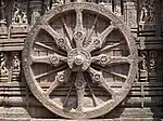
Zigzag from Top-left: Kichakeshwari Temple in Khiching (first capital of Mayurbhanj), Haripurgarh second capital of the state, Barehipani and Debakunda waterfall in Simlipal National Park, UNESCO recognised Mayurbhanj style Chhau dance | |
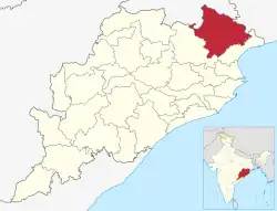 Location in Odisha | |
| Coordinates: 21.933°N 86.733°E | |
| Country | India |
| State | |
| Headquarter | Baripada |
| Government | |
| • Member of Parliament | Bishweswar Tudu (BJP) |
| • Collector & District Magistrate | Vineet Bhardwaj, IAS |
| • Superintendent of Police | B. Gangadhar, IPS |
| Area | |
| • Total | 10,418 km2 (4,022 sq mi) |
| • Urban | 108 km2 (42 sq mi) |
| • Rural | 10,309 km2 (3,980 sq mi) |
| • Rank | 1st (in State); 57th (in India) |
| • Forest | 4,392 km2 (1,696 sq mi) |
| Elevation | 559.31 m (1,835.01 ft) |
| Highest elevation (Khairiburu) | 1,178 m (3,865 ft) |
| Population (2011)[1] | |
| • Total | 2,519,738 |
| • Rank | 3rd (in State); 171st (in India) |
| • Density | 240/km2 (630/sq mi) |
| • Urban | 192,896 (7.66%) |
| • Rural | 2,326,842 (92.34%) |
| • Scheduled Castes | 184,682 (7.33%) |
| • Scheduled Tribes | 1,479,576 (58.72%) |
| Languages | |
| • Official | Odia and English |
| • Regional | Santali, Ho, Mundari,[lower-alpha 1] Kurmali, Bengali |
| Time zone | UTC+5:30 (IST) |
| PIN | 757001 |
| Vehicle registration | OD-11-xxxx |
| Sex ratio | 1,005 ♂/♀ |
| Literacy | 63.17% |
| Climate | Aw (Köppen) |
| Precipitation | 1,648.2 mm (64.89 in) |
| Lok Sabha constituency | Mayurbhanj[lower-alpha 2] |
| Vidhan Sabha constituency | 9 constituency:
|
| Website | www |


.jpg.webp)

| This article is part of a series on |
| Odisha |
|---|
 |
| Governance |
|
| Topics |
|
Districts Divisions |
| GI Products |
|
|
Etymology
The name of the district is a portmanteau of Mayura (meaning peacock in Odia) and Bhanja, the name of the ruling dynasty of the district till 1949. It is believed that the Mayura was the name of another dynasty that merged with the Bhanjas sometime around the 14th century. The peacock motif was later adopted by the Bhanjas and featured on the Mayurbhanj coat of arms. The Mayurbhanj alternative spellings were noted as Mohurbunge, Morebunge and Morbhanj in many British India records.[3]
History
Early history
The Lower Palaeolithic Culture in Mayurbhanj district is characterized by the presence of tools, providing evidence of early human occupation during the Middle Pleistocene era. While no human or animal fossils have been discovered alongside these tools, comparisons with other regions suggest that this culture thrived along the banks of the Burhabalanga River and its tributaries. The perennial water source not only sustained early humans but also attracted wildlife, enabling them to hunt smaller animals from the safety of their caves. The region's thin forest cover offered edible roots and fruits. Initially, the tools used were quite basic, including split pebbles with minimal flaking, similar to those found in Africa's Lower Pleistocene industries.
These tools evolved over time to include handaxes, cleavers, scrapers, knives, rostrocarinates, and points, varying in complexity, shape, and size. Stratigraphy does not provide a means to categorize them into distinct groups for understanding their technical development. Typo-technological analysis suggests the presence of two specific tool types with manufacturing techniques akin to European Abbevilian, Acheulian, and Clactonian industries, indicating rapid technological advancement. However, unlike European counterparts, the Mayurbhanj Lower Palaeolithic culture lacks a distinct flake industry.
Mediaeval and modern history

The Bhanja family, which ruled Mayurbhanj State, holds a significant place in the district's history. The Bhanjas of Khijjinga mandala governed the western region of the present-day Mayurbhanj district, including parts of Kendujhar and West Singhbhum districts, with their headquarters at Khiching after the fall of the Buddhist Bhauma-Kara dynasty. The progenitor of the present-day Bhanjas of Khijjinga mandala divided the territory into two segments, each led by one rulers, effectively forming two full-fledged states. One relocated the capital from Khiching to Haripur and subsequently renamed the territory into Mayurbhanj State, while the other moved it to Kendujhargarh and named it into Keonjhar State after Feroz Shah Tughlaq plundered the kingdom during his invasion of Odisha in 1361 CE, when he marched through Manbhum, Singhbhum, and Mayurbhanj.[4] In 1508, the state came under Mughal rule. During his conquest from 1592 to 1751, Mayurbhanj was an extensive domain that comprised 12 zaminadri, 42 killa in total, and, according to Raja Man Singh, 18 forts within the state, including Bhanjbhum, Mantri, Hariharapur, Dewalia, Purunia, Karkachua, Bamanghati, and Sarhonda. The state also held sway over several surrounding zamindari estates, including Nilgiri, Porahat, Saraikela, Kharsawan, Barabhum, Patharhai, Narsinhpur, Dipa Kiarchand, Jhamrapal, Jamkunda, Chargarh, Talmunda, Tamar, and Birkul during the early period of Mughal rule. All of these territories encompassed present-day Kendujhar, Balasore, Singhbhum, and large parts of the undivided Midnapore districts. Raja Krushna Chandra Bhanja took advantage of the disturbed conditions around the last years of Shah Jahan and enlarged his territory to the coast of the Bay of Bengal, covering the area from Jaleswar to Bhadrak. He was however defeated and executed by Khan e Dauran, the general of Emperor Aurangzeb.

In 1751, it came under Maratha rule. During the expansion of the Maratha Empire, the state lost all its territories along the coast as well as the Nilgiri State. The loss of the sea ports along the Balasore coast severely affected the state finances. It was around this time that the capital was shifted to Baripada. In 1803, the state submitted to the British who had conquered coastal Odisha and the state was recognised as a feudatory state – a position midway between a princely state and a Zamindari. However, the state remained independent and acted as a buffer state between Maratha and British rule by maintaining friendly relations with British authorities. In the mid-19th century, further territorial concessions were made to the British when large parts of Bamanghati area, such as Thai, Bharbharia, Anla, Lalgarh, Khuchung (now in Saraikela Kharsawan district), and Haladipokhari, were handed over to the Singhbhum district as a consequence of persistent Kol uprisings.[5]

The state was modernised during the short reign of Maharaja Sriram Chandra Bhanj Deo in the early 20th century. The railway, primary education, municipal governance and healthcare were all introduced around this time. He also allowed the Jamsetji Tata to mine iron ore at Gorumahisani leading to the establishment of Jamshedpur and Tata Steel just outside the state borders. In a notable judgement during his reign, the Calcutta High Court held that the Mayurbhanj State as well as all other feudatory states of Odisha were not parts of British India, thus elevating them to the status of full princely states. Mayurbhanj was the largest and most populous of all princely states in Odisha and the Maharaja enjoyed a salute of 9 guns.
Merger of the state
Following India's independence on 15th August 1947, the State of Mayurbhanj became an independent unit and soon after, a State Legislative Assembly was formed with cabinet ministers (praja mandal). These ministers included Chief Minister Sarat Chandra Das (Minister of Home, Finance, Audit, Planning and Reconstruction), M. Mahapatra (Minister of Revenue, Law, Health & Local Government), and M. Nayak (Minister of Development, Education, Supply, Transport, Public Works, Commerce, and Labour) by a proclamation of the Maharaja on 9th December 1947.[6][7] The Maharaja formally transferred most of his powers to this body. When Sardar Patel, the then Home Minister, met the rulers of the state with his proposal for merger with India on 14th December 1947, the Maharaja of Mayurbhanj said that he had already granted responsible Government in his State, and hence he could not make any commitment without consulting his Ministers. In view of this and being a tribal state, Patel didn't compel the merger. The premier of state was left out of the discussions. On 17th October 1948, the Maharaja and Chief Minister went to Delhi and the Maharaja signed an Instrument of Merger with stipulations,[8] keeping in mind the mismanagement and social instability of the state. The administration of the State was taken over by the Government of India with effect from 9th November 1948, and a Chief Commissioner was appointed to administer the State. However, it was subsequently decided that since Mayurbhanj linguistically and culturally had close links with Odisha, it should merge with that Province. On 16th December, 1949, V. P. Menon came to the Baripada and announced the merger of Mayurbhanj with Odisha, which officially effected from 1st January 1949.[9][10] Through the merging with Odisha was not peaceful. The Non-Odia inhabitants, primarily the Santhals, headed by Sunaram Soren proposed that the state either remain as a Union territory of India or merge with Jharkhand, then proposed state of Bihar.[11][12]
Geography and climate
Mayurbhanj is land-locked with a geographical area of 10,418 km2 (4,022 sq mi) and lies in the north east corner of the state. It is bordered on the northeast by Jhargram district of West Bengal and East Singhbhum district of Jharkhand, to the north by Seraikela Kharsawan district of Jharkhand, West Singhbhum district of Jharkhand on the west, Kendujhar district on the southwest and Balasore district on the southeast.[2]
Mayurbhanj's geography is defined by the Simlipal National Park located in the centre of the district. Covering more than a fourth of the district's area, these forests surround the Simlipal Hills, which form the watershed for the district. The hills reach a height of 3824 feet at Meghasani towards the south and also have many other peaks above 2500 feet. The northern parts of these hills have been mined for iron ore for more than a century. The country to the east of Simlipal is an extension of the Odisha coastal plains and is drained by the Subarnarekha River and Budhabalanga River along with their tributaries. The land is almost level with a slight slope to the coast. The indigenous vegetation consisted of pure Sal forests which have now been replaced by paddy cultivation.
The western plains of Mayurbhanj are an extension of the Odisha Plateau. They are mostly flat with small hills and slopes but are at a higher altitude than the eastern plains, the height rising from north to south. The streams here drain into the Baitarani River in Kendujhar or flow into Jharkhand to the north. There are still isolated open forests to be seen, but paddy is the most common cultivated crop.
The Budhabalanga is the main river of Mayurbhanj. It arises in the Simlipal Hills and forms the waterfall at Barehipani in a northward course. It then turns to the south east and flows between steep banks and sandbars. Both Baripada and the ancient capital of Haripur are located along its banks. The river receives two small tributaries before entering the Bay of Bengal beyond Balasore. Other important minor rivers are Deo, Sone, Gangahar and Salandi. Floods are uncommon except during exceptional rainfall in the hills owing to the seasonal nature of the streams and their steep banks.
The climate of Mayurbhanj is sub tropical marked by high humidity and rainfall during the Monsoon. The Simlipal Hills influence the weather substantially and exhibit higher rainfall and lower maximum temperatures than the rest of the district. The average annual rainfall is around 164 cm (65 in). Summer temperatures in Baripada can occasionally cross 45 degree Celsius but thunderstorms in the evening are common which have a moderating influence. Minimum temperature in winter can go down to 8 degrees. Fog occurs occasionally during winters.
Transport
The road network of Mayurbhanj is organised in a circular manner owing to the presence of the Simlipal Hills and forest in the centre of the district. National Highway 18 takes off from the Kolkata-Chennai highway near Simulia in Balasore. It shortly thereafter enters the district and passes the major villages of Baisinga, Betnoti and Krushnachandrapur before crossing Baripada and Jharpokharia. It finally exits the district at Jamsola to enter East Singhbhum district for a total length of 86 km (53 mi).
National Highway 49 also enters the district at Jamsola. It then crosses Bangriposi and Jashipur before entering Kendujhar district. This is the main highway connecting Kolkata with Mumbai and therefore sees heavy traffic throughout the year. National Highway 220 covers the stretch from Karanjia to Tiring passing through Jashipur and Rairangpur on the way. Odisha state highway 19 is another important state highways link the district headquarter Baripada from Jaleswar, Udala and Gopiballavpur I of West Bengal.
The Mayurbhanj State Railway was a 2 ft 6 in (762 mm) narrow gauge line funded by the Mayurbhanj State that connected Talbandh in the Simlipal Hills to Rupsa on the Bengal Nagpur Railway mainline, mainly to carry timber. The major stations en route were Bangriposi and Baripada. The line was shut down in 2002 and reopened after conversion to broad gauge in 2007. The Talbandh-Bangriposi stretch has been abandoned for many years now and the line terminates at the latter station. The total length within the district is 83 km (52 mi). Another electrified broad-gauge line from Jamshedpur enters the district at Bahalda before splitting at Aunlajhori. One branch goes to Badampahar while the other terminates at Gorumahisani. The total length of these lines is about 63 km (39 mi) and they are used exclusively to ferry iron ore from the mines at the above locations. Both these routes fall under the South Eastern Railway.
Mayurbhanj has no active airports, although RAF Amarda Road was a major base for the Royal Air Force and the United States Army Air Forces during World War II. Another abandoned airfield, once used by the Maharaja of Mayurbhanj, is located at Rajabasa near Baripada. However, the nearest Kalaikunda Air Force Station, located in Kharagpur, is used for official purposes.
Administration
The District is headed by the Collector and District magistrate, usually an officer of the Indian Administrative Service (IAS) who oversees development, revenue collection and maintenance of law and order. He is assisted at headquarters by two Additional District Magistrates (ADM) and a number of Deputy Collectors. Various line departments ranging from Agriculture and Education to Health are operate under the Collector's supervision. There are four territorial subdivisions of the district – Sadar (headquartered at Baripada), Kaptipada (Udala), Bamanghaty (Rairangpur) and Panchpir (Karanjia) composing 26 blocks, 382 Gram Panchayats and 3945 villages.[13] Each subdivision is headed by a Sub Collector cum Sub Divisional Magistrate who reports to the Collector. Except for the Sadar Sub Collector, who is often an IAS officer, the other Sub Collectors and ADMs belong to the Odisha Administrative Service.
The police force is headed by a Superintendent of Police belonging to the Indian Police Service who is assisted by Additional SPs at headquarters and SDPOs at subdivisional headquarters. There are a total of 32 police stations – each headed by an Inspector or Sub Inspector in-charge. While the Superintendent reports on general law and order matters to the District Magistrate, he is almost completely independent in practice as far as the police force is concerned.
Each subdivision is further divided into blocks and tahsils. The former are development units headed by a Block Development Officer. Each block is divided into numerous Gram Panchayats (GPs) for a total of 404 in the district. The GPs and Blocks report to the Project Director, District Rural Development Authority (DRDA), an ADM rank officer. The Collector is the CEO of DRDA and thus exercises direct control over its functioning. The tahsils on the other hand are revenue subdivisions with the Tahsildar also being an Executive Magistrate and reporting to the Sub Collector. He is assisted by a number of Revenue Inspectors and Amins. The district has a total of 26 blocks and tahsils, the highest in Odisha.
The Simlipal National Park, while formally a part of the four subdivisions noted above, is in practice under a Field Director belonging to the Indian Forest Service (IFS). The Deputy Director, also an IFS officer, is responsible for the day-to-day operations of the Park. Three other Divisional Forest Officers are in charge of the forests outside the National Park area.
The Judiciary is headed by a District and Sessions Judge who exercises both criminal and civil jurisdiction. He also enjoys revisionary powers over certain orders of the District Magistrate and Sub Divisional Magistrates. He is assisted on the civil side by Civil Judges of senior and junior divisions and on the criminal side by Chief Judicial Magistrate and Sub Divisional Judicial Magistrates.
Demographics
| Year | Pop. | ±% p.a. |
|---|---|---|
| 1872 | 258,680 | — |
| 1881 | 385,737 | +4.54% |
| 1891 | 532,223 | +3.27% |
| 1901 | 610,383 | +1.38% |
| 1911 | 729,218 | +1.79% |
| 1921 | 754,314 | +0.34% |
| 1931 | 889,603 | +1.66% |
| 1941 | 984,741 | +1.02% |
| 1951 | 1,028,825 | +0.44% |
| 1961 | 1,204,043 | +1.59% |
| 1971 | 1,434,200 | +1.76% |
| 1981 | 1,581,873 | +0.98% |
| 1991 | 1,884,580 | +1.77% |
| 2001 | 2,223,456 | +1.67% |
| 2011 | 2,519,738 | +1.26% |
| Source: Mayurbhanj district Gazetteer & Census of India[14][15] | ||
According to the 2011 census Mayurbhanj district has a population of 2,519,738,[1] roughly equal to the nation of Kuwait[16] or the US state of Nevada.[17] This gives it a ranking of 171st in India (out of a total of 640). The state also held the 3rd rank in India in terms of the number of villages, with 3,950 villages. The district has a population density of 241 inhabitants per square kilometre (620/sq mi). Its population growth rate over the decade 2001–2011 was 13.06%. Mayurbhanj has a sex ratio of 1006 females for every 1000 males, much higher than the Indian average of 940 and a literacy rate of 63.98%, slightly lower than the Indian average. 7.66% of the population lives in urban areas. Scheduled Castes and Scheduled Tribes make up 7.33% and 58.72% of the population respectively.[1] The bulk of the population is concentrated in the Sadar and Kaptipada subdivisions which border the fertile coastal Odisha plains and are part of an extensive rice growing region. Bamanghat also has a large population engaged in agriculture and industry.
Tribes and communities
The Odia people form the largest population segment. Their castes are the same as that of the neighbouring district of Balasore. A distinctive feature is the presence of many communities that originally hailed from West Bengal but have completely integrated with the Odia population in the last two centuries. The Odias are especially dominant in the Kaptipada subdivision and in the adjoining blocks of Sadar. Odia Scheduled Castes make up 7.32% of the population and belong to a wide variety of groups, with no one community dominating.
Tribals are the largest group forming 58.72% of the population. The Santal people are the largest tribe and are the second-largest group in the district as a whole. A large number of them are immigrants from what is now Singhbhum during the 18th and 19th centuries. The practice of shifting cultivation and jungle clearance meant that the Santals were always on the lookout for forested uncultivated land that could take pressure of a growing population. Increasingly, the Santals settled in Mayurbhanj acquired some degree of fluency in Odia while continuing to speak Santali among themselves. The Ho people form the second largest tribal group followed by the Bhumij. All three tribes speak languages that are a part of the Munda languages family and are therefore distinct from the prevalent Indo Aryan languages of Odia, Hindi and Bengali, that are spoken nearby. The Bhumij, on the other hand, have mostly adopted Odia as their language although 40% still speak Bhumij. Other tribes include the Odia-speaking Bathudi, Bhuyan and Gonds, as well as the Sounti and Kharia. As per 1931 census, the district was comprised by 131 different communities, primarily by Santal (28.61%), Ho (Kolha) (12.07%), Bhumij (8.71%), Kudmi Mahato (6.77%), Bathudi (5.19%), Goura (4.39%), Pana Tanti (3.38%), Bhuyan (2.62%), Khandaita (2.23%), Bhanja Purana (2.2%) and other communities like Kamar, Kumbhar, Gond, Kharia, Brahmin, Teli, Saunti, Dhoba, Tanti, Gola, Dom, Bhandari, Karana, Patra, Baisnaba, Ghasi, Sadgop, Mahali, Sabara, Amanta, Sundhi, Pan (Jena Pan), Purana, Keut, Hadi, Dhandachhatra Majhi, Raju, Kshatriya, Ujia, Bagal, Gouria, Rarhi, Oraon, Baisa, Karua, Thatari, Sahara, Kayastha, Rajuar, Munda constitute 20.35% with each community shared by 0.9% to 2.0%. The rest of 3.24% was shared by minority communities whose population below 1,000 in the district.[18]
Religion
According to the 2011 Census 83.86% people are Hindus, 1.34% are Muslims, 0.60% are Christians, 0.03% are Sikhs and Jains while Adivasi faiths comprise the rest. Hinduism in its usual form is practised by the Odia people. Baripada is an important religious centre, having one of the oldest Jagannath temples in the state as well as a much revered temple of Maa Ambika, the patron deity of the town. Semi Buddhistic practises involving the worship of Mahayana deities like Tara and Avalokiteshvara under different names are common in villages. A large segment of the tribal population also follows Hinduism with a substantial amount of tribal rites and rituals. The ancestral faith of Santals, Sarna involves nature worship and reverence for sacred groves and is also widely practised.
Muslims and Christians comprise a tiny minority. The former are almost all migrants from Coastal Odisha except for a sizeable population of Bihari Muslims near the border with Chaibasa. Christians are mostly converts from tribal communities. There is an old Evangelical Church at Baripada and a Roman Catholic church at Krushnachandrapur.
Languages
At the time of the 2011 Census of India, 54.33% of the population in the district spoke Odia, 24.81% Santali, 7.58% Ho, 3.92% Mundari, 2.77% Kurmali and 1.34% Bengali as their first language.[20]
A large segment of the tribal population is fluent in Odia in addition to their native language. The Mayurbhanj dialect is almost the same as that of Coastal Odisha though certain tribal words for everyday objects are used, especially in the villages. The native language of Santali is largely used in its spoken form, Odia or Hindi being preferred for writing. The Ol Chiki script is rarely seen and the Odia script is used to write other tribal languages as well. Bengali is used in the parts of Sadar subdivision that adjoin Jhargram district, although there is significant Odia admixture. Kudmali is another important language, primarily spoken by the Kudumi Mahato in the border areas of Jharkhand and West Bengal. Where they have significant population. Other tribal languages include Ho and Bhumij (sometimes regarded as a Mundari dialect).[lower-alpha 1] Lodha is spoken by several thousand people.
Culture and heritage
Mayurbhanj District in Odisha is known for its rich cultural heritage and vibrant traditions. The district celebrates two prominent festivals, Makar Parva and Karama Parva. The famous Chhau dance, a dynamic dance form, has gained worldwide recognition. Mayurbhanj District is also associated with Jhumar, a popular traditional folk song that reflects the community's celebrations, marriages, social functions, sorrows, and joys.[21]
- Ratha Yatra
In Baripada, Lord Jagannath is worshipped as Shri Shri Haribaldev Mahaprabhu, alongside the revered Puri temple. The Haribaldev temple in Baripada, built in 1575 A.D., is made of laterite stone with intricate designs. It features Vimana, Jagamohan, and Nata Mandira structures and is surrounded by a boundary wall. The temple is well-preserved and hosts the annual Car festival, during which the three deities are brought to the Radhamohan Temple (Mausimaa Mandir) for a two-day event. The Baripada Car festival involves women exclusively in pulling Maa Subhadra's chariot.
- Chhau dance
Mayurbhanj Chhau dance, which has gained global recognition, such as UNESCO cultural heritage for its artistry and vigor. It draws inspiration from various sources, including the Ramayana, the Mahabharata, folk traditions, and tribal elements.
- Jhumar
Jhumar, a popular traditional folk song and dance form. Jhumar is performed on various occasions, such as weddings, festivals, and social functions. It features lively music, rhythmic beats, and energetic dance movements. The songs depict themes of love, romance, and everyday life experiences. Jhumar serves as a cultural expression, preserving the folk traditions and heritage of the region.
Politics
The following is the nine Vidhan sabha constituencies[22][23] of Mayurbhanj district.
| No. | Constituency | Reservation | Extent of the Assembly Constituency (Blocks) | Member of 16th Assembly | Party | |
|---|---|---|---|---|---|---|
| 26 | Jashipur | ST | Jashipur, Raruan, Sukruli, Kusumi (part) | Ganesh Ram Singh Khuntia | BJP | |
| 27 | Saraskana | ST | Saraskana, Bijatala, Bisoi, Kusumi (part) | Dr. Budhan Murmu | BJP | |
| 28 | Rairangpur | ST | Rairangpur (NAC), Rairangpur, Tiring, Bahalda, Jamda | Naba Charan Majhi | BJP | |
| 29 | Bangriposi | ST | Bangriposi, Kuliana, Samakhunta | Sudam Marndi | BJD | |
| 30 | Karanjia | ST | Karanjia (NAC), Karanjia, Thakurmunda, Kaptipada (part) | Basanti Hembram | BJD | |
| 31 | Udala | ST | Udala (NAC), Udala, Gopabandhunagar, Kaptipada (part) | Bhaskar Madhei | BJP | |
| 32 | Badasahi | SC | Betnoti, Badasahi (part) | Sanatana Bijuli | BJP | |
| 33 | Baripada | ST | Baripada (M), Baripada, Khunta, Badasahi (part) | Prakash Soren | BJP | |
| 34 | Morada | None | Morada, Suliapada, Rasgobindapur | Rajkishore Das | BJD | |
Notable people
- Droupadi Murmu, current president of India
- G. C. Murmu, CAG of India
- Soumya Ranjan Patnaik, politician and founder of Sambad news paper
References
Footnotes
- A significant number of Bhumij are recorded as speaking 'Bhumijali' in the census, which is classified as a dialect of Odia, although this could be another name for the Bhumij dialect of Mundari.
- The Mayurbhanj Lok Sabha constituency covers seven assembly constituencies in the Mayurbhanj district, while the other two assembly constituencies of the district, namely Badsahi and Karanjia, are part of the Balasore and Kendujhar Lok Sabha constituencies, respectively.
Sources
- "District Census Handbook 2011 – Mayurbhanj" (PDF). Census of India. Registrar General and Census Commissioner of India.
- "About District | Mayurbhanj District, Government of Odisha | India". Retrieved 10 June 2020.
- Taradatt & Basa.
- Senapati & Sahu 1967, pp. 1–2.
- Senapati & Sahu 1967, pp. 2–3.
- Mishra, D. P. (1998). People's Revolt in Orissa: A Study of Talcher. Atlantic Publishers & Dist. p. 48. ISBN 978-81-7156-739-3.
- Das, Kalpana (August 2011). "Untold Stories of 1st Responsible Govt. of Mayurbhanj" (PDF). Orissa Review.
- White Paper On Indian States. Delhi: Government Of India Press. 1950. pp. 180–182. Archived from the original on 18 January 2017.
- Ahmed, M. (1967). Census of India, 1961 :Orissa (PDF). District Census Handbook : Mayurbhanj. Cuttack: Superintendent, Orissa Government.
- Senapati & Sahu 1967, pp. 2–4.
- Sachan, Jatindra Nath Singh Dev (2010). "Tribal Uprising of Mayurbhanj in 1949". Proceedings of the Indian History Congress. 71 (2): 712–721. ISSN 2249-1937. JSTOR 44147540.
- MENON, V. P. (1961). THE STORY OF THE INTEGRATION OF THE INDIAN STATES. ORIENT LONGMANS, BOMBAY.
- "Mayurbhanj/District Court in India | Official Website of District Court of India". districts.ecourts.gov.in. Retrieved 19 September 2022.
- Senapati & Sahu 1967, pp. 92–93.
- "A-2 DECADAL VARIATION IN POPULATION SINCE 1901 (21 A-2 Odisha)" (PDF). www.censusindia.gov.in. Archived from the original (PDF) on 17 June 2014.
- US Directorate of Intelligence. "Country Comparison:Population". Archived from the original on 13 June 2007. Retrieved 1 October 2011.
Kuwait 2,595,62
- "2010 Resident Population Data". U. S. Census Bureau. Archived from the original on 19 October 2013. Retrieved 30 September 2011.
Nevada 2,700,551
- Laeequddin, Muhammad (1935). Census of Mayurbhanj State 1931. Vol. II. Calcutta. JSTOR saoa.crl.25352831. OCLC 496724918.
{{cite book}}: CS1 maint: location missing publisher (link) - "Table C-01 Population by Religious Community: Odisha". Census of India, 2011. Registrar General and Census Commissioner of India.
- "Table C-16 Population by Mother Tongue: Odisha". Census of India 2011. Registrar General and Census Commissioner of India.
- "Culture & Heritage | Mayurbhanj District, Government of Odisha | India". Retrieved 27 June 2023.
- "Assembly Constituencies and their EXtent" (PDF). eci.nic.in.
- "Seats of Odisha". eci.nic.in.
Gazetteers
- Senapati, Nilamani; Sahu, Nabin Kumar (1967). "Orissa District Gazetteers: Mayurbhanj". INDIAN CULTURE. Cuttack: Superintendent Orissa Government Press. Archived from the original on 4 March 2021. Retrieved 19 September 2022.
- Taradatt, Dr; Basa, Kishor K (eds.). Odisha District Gazetteer (Mayurbhanj) (PDF). Gopabandhu Academy of Administration [Gazetters Unit], General Administration Department Government Of Odisha. Archived (PDF) from the original on 7 May 2021.
External links
Places adjacent to Mayurbhanj district | |
|---|---|