Mazatenango, Suchitepéquez
Mazatenango is a city with a population of 77,431 (as of 2018)[2] and a municipality in the Suchitepéquez department of Guatemala. It is the capital of Suchitepéquez department, and is located 165 km from Guatemala City.
Mazatenango | |
|---|---|
Municipality | |
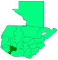
 Mazatenango Location in Guatemala | |
| Coordinates: 14°32′N 91°30′W | |
| Country | |
| Department | |
| Government | |
| • Mayor | Manuel Delgado |
| Area | |
| • Municipality | 86 sq mi (223 km2) |
| Elevation | 1,227 ft (374 m) |
| Population (2018 census)[1] | |
| • Municipality | 77,431 |
| • Density | 900/sq mi (350/km2) |
| • Urban | 77,431 |
| Climate | Am |
It lies significantly lower in elevation than Guatemala City or Quetzaltenango, as it sits on the coastal plain leading to the Pacific Ocean. The climate is hotter and more humid than that of the other cities in higher elevations..
Carnival
During the month of February, an eight-day Carnival Feast takes place in the city, with food, music, parades, and games.
Arts and crafts
Mazatenango is a major producer of gold, silver, tile, fabric, and furniture. It's also a major commercial centre for the economy. This region provides many of the products tourists buy at the markets. Goods are shipped to other cities via the Pacific Coast Highway which runs through the city.
Sports
Mazatenango is home to Guatemala's top division football side CD Suchitepéquez. The team plays its home fixtures at Estadio Carlos Salazar Hijo in the Santa Cristina neighborhood.
Language
Spanish and Kich’e are spoken in Mazatenango.
References
- Citypopulation.de Population of departments and municipalities in Guatemala
- Citypopulation.de Population of cities & towns in Guatemala