Mecklenburg County, North Carolina
Mecklenburg County is a county located in the southwestern region of the state of North Carolina, in the United States. As of the 2020 census, the population was 1,115,482,[1] making it the second-most populous county in North Carolina (after Wake County) and the first county in the Carolinas to surpass one million in population.[2] Its county seat is Charlotte, the state's largest community.[3]
Mecklenburg County | |
|---|---|
 Flag  Seal | |
| Nickname: Meck County | |
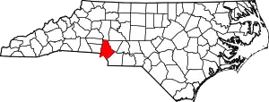 Location within the U.S. state of North Carolina | |
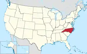 North Carolina's location within the U.S. | |
| Coordinates: 35°15′N 80°50′W | |
| Country | |
| State | |
| Founded | December 11, 1762 |
| Named for | Charlotte of Mecklenburg-Strelitz |
| Seat | Charlotte |
| Largest community | Charlotte |
| Area | |
| • Total | 546.09 sq mi (1,414.4 km2) |
| • Land | 523.61 sq mi (1,356.1 km2) |
| • Water | 22.48 sq mi (58.2 km2) 4.12% |
| Population (2020) | |
| • Total | 1,115,482 |
| • Estimate (2022) | 1,145,392 |
| • Density | 2,130.37/sq mi (822.54/km2) |
| Demonym | Mecklenburger |
| Time zone | UTC−5 (Eastern) |
| • Summer (DST) | UTC−4 (EDT) |
| Congressional districts | 12th, 14th |
| Website | www |


.jpg.webp)

Mecklenburg County is the central county of the Charlotte-Concord-Gastonia, NC-SC Metropolitan Statistical Area. On September 12, 2013, it was estimated the county surpassed one million residents.[4]
Like its seat, the county is named after Charlotte of Mecklenburg-Strelitz, Queen of the United Kingdom (1761–1818), whose name is derived from the region of Mecklenburg in Germany, itself deriving its name from Mecklenburg Castle (Mecklenburg meaning "large castle" in Low German) in the village of Dorf Mecklenburg.
History
Mecklenburg County was formed in 1762 from the western part of Anson County, both in the Piedmont section of the state. It was named in commemoration of the marriage of King George III to Charlotte of Mecklenburg-Strelitz,[5] for whom the county seat Charlotte is named. Due to unsure boundaries, a large part of south and western Mecklenburg County extended into areas that would later form part of the state of South Carolina. In 1768, most of this area (the part of Mecklenburg County west of the Catawba River) was designated Tryon County, North Carolina.
Determining the final boundaries of these "western" areas between North and South Carolina was a decades-long process. As population increased in the area following the American Revolutionary War, in 1792 the northeastern part of Mecklenburg County was taken by the North Carolina legislature for Cabarrus County. Finally, in 1842 the southeastern part of Mecklenburg County was combined with the western part of Anson County to form Union County.
The Mecklenburg Declaration of Independence was allegedly signed on May 20, 1775, and if the document is genuine, Mecklenburg County was the first part of the Thirteen Colonies to declare independence from Great Britain.[6] The "Mecklenburg Resolves" were adopted on May 31, 1775. Mecklenburg continues to celebrate the declaration each year in May,[7] the date of which is included on the flag of North Carolina.
The first gold rush in the United States, the Carolina Gold Rush, began after a 12-year-old boy named Conrad Reed discovered a gold nugget in a stream in neighboring Cabarrus County. Many miners and merchants began settling in the county during that time. The first United States branch mint was established in 1837 and would continue operations until 1913.[8] The original building was moved from its original location and turned into a museum.
In 1917, during World War I, Camp Greene was established west of Charlotte as a training camp for the army. In 1919, it was decommissioned after the end of WWI.[9] Around the 1930s and 1940s, the population began to rapidly increase. During this time, Carolinas Medical Center and Charlotte College (now the University of North Carolina at Charlotte) were built.[10][11][12] Lake Norman was also completed in 1964, after a five-year construction period.
In the mid-20th century, the county continued to see rapid growth. Many new government buildings were constructed, Charlotte Douglas International Airport was also expanded in 1954. By 1960, a quarter million people were living in the county with that number becoming half a million by 1990.[8] An unsuccessful attempt to form a consolidated city-county government was tried in 1971, but was voted down by residents.[13] The metropolitan statistical area now includes 6 counties in both North Carolina and South Carolina with a combined population of 2,660,329 in 2020.[10][14]
In mid-2020, the county was the site of the 2020 Colonial Pipeline oil spill, wherein about 2,000,000 U.S. gal (7,600,000 L) of gasoline leaked from the Colonial Pipeline in the Oehler Nature Preserve near Huntersville. It is one of the largest gasoline spills in U.S. history and cleanup efforts are expected to last for several years.
Geography
According to the U.S. Census Bureau, the county has a total area of 546.09 square miles (1,414.4 km2), of which 523.61 square miles (1,356.1 km2) is land and 22.48 square miles (58.2 km2) (4.12%) is water.[15]
State and local protected areas/sites
- Carolina Raptor Center[16]
- Charlotte Museum of History[17]
- Historic Latta Place[18]
- Historic Rural Hill/Nature Preserve[19]
- Little Sugar Creek Greenway[20]
- Mint Museum Randolph, uses the original Charlotte Mint building[21]
- Mint Museum Uptown[22]
- Oehler Nature Preserve[23]
- President James K. Polk Historic Site[24]
Nature preserves in Charlotte:[25]
- Auten Nature Preserve
- Cowans Ford Wildlife Refuge
- Ferrelltown Nature Preserve
- Latta Nature Preserve
- McDowell Nature Preserve
- Possum Walk Nature Preserve
- Reedy Creek Nature Preserve
- Sherman Branch Nature Preserve
- Stevens Creek Nature Preserve
Major water bodies
Adjacent counties
- Iredell County – north
- Cabarrus County – northeast
- Union County – southeast
- Lancaster County, South Carolina – south
- York County, South Carolina – southwest
- Gaston County – west
- Lincoln County – northwest
Demographics
| Census | Pop. | Note | %± |
|---|---|---|---|
| 1790 | 11,395 | — | |
| 1800 | 10,439 | −8.4% | |
| 1810 | 14,272 | 36.7% | |
| 1820 | 16,895 | 18.4% | |
| 1830 | 20,073 | 18.8% | |
| 1840 | 18,273 | −9.0% | |
| 1850 | 13,914 | −23.9% | |
| 1860 | 17,374 | 24.9% | |
| 1870 | 24,299 | 39.9% | |
| 1880 | 34,175 | 40.6% | |
| 1890 | 42,673 | 24.9% | |
| 1900 | 55,268 | 29.5% | |
| 1910 | 67,031 | 21.3% | |
| 1920 | 80,695 | 20.4% | |
| 1930 | 127,971 | 58.6% | |
| 1940 | 151,826 | 18.6% | |
| 1950 | 197,052 | 29.8% | |
| 1960 | 272,111 | 38.1% | |
| 1970 | 354,656 | 30.3% | |
| 1980 | 404,270 | 14.0% | |
| 1990 | 511,433 | 26.5% | |
| 2000 | 695,454 | 36.0% | |
| 2010 | 919,628 | 32.2% | |
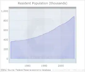
| 2020 | 1,115,482 | 21.3% | |
| 2022 (est.) | 1,145,392 | [1] | 2.7% |
| U.S. Decennial Census[26] 1790–1960[27] 1900–1990[28] 1990–2000[29] 2010–2020[1] | |||
2020 census
| Race | Number | Percentage |
|---|---|---|
| White (non-Hispanic) | 498,683 | 44.71% |
| Black or African American (non-Hispanic) | 324,832 | 29.12% |
| Native American | 2,730 | 0.24% |
| Asian | 71,583 | 6.42% |
| Pacific Islander | 531 | 0.05% |
| Other/Mixed | 47,201 | 4.23% |
| Hispanic or Latino | 169,922 | 15.23% |
As of the 2020 census], there were 1,115,482 people, 426,313 households, and 254,759 families residing in the county.
2000 census
At the 2000 census,[31] there were 695,454 people, 273,416 households, and 174,986 families residing in the county. The population density was 1,322 people per square mile (510 people/km2). There were 292,780 housing units at an average density of 556 units per square mile (215 units/km2). The racial makeup of the county was 64.02% White, 27.87% Black or African American, 0.35% American Indian/Alaska Native, 3.15% Asian, 0.05% Pacific Islander, 3.01% from other races, and 1.55% from two or more races. 6.45% of the population were Hispanic or Latino of any race.
There were 273,416 households, out of which 32.10% had children under the age of 18 living with them, 47.70% were married couples living together, 12.40% had a female householder with no husband present, and 36.00% were non-families. 27.60% of all households were made up of individuals, and 5.90% had someone living alone who was 65 years of age or older. The average household size was 2.49 and the average family size was 3.06.
In the county, the population was spread out, with 25.10% under the age of 18, 9.70% from 18 to 24, 36.40% from 25 to 44, 20.30% from 45 to 64, and 8.60% who were 65 years of age or older. The median age was 33 years. For every 100 females there were 96.50 males. For every 100 females age 18 and over, there were 93.60 males.
The median income for a household in the county was $50,579, and the median income for a family was $60,608. Males had a median income of $40,934 versus $30,100 for females. The per capita income for the county was $27,352. About 6.60% of families and 9.20% of the population were below the poverty line, including 11.50% of those under age 18 and 9.30% of those age 65 or over.
Law and government
Mecklenburg County is a member of the regional Centralina Council of Governments.[32]
The county is governed by the Mecklenburg Board of County Commissioners (BOCC). The BOCC is a nine-member board made up of representatives from each of the six county districts and three at-large representatives elected by the entire county. This electoral structure favors candidates in the at-large positions who will be elected by the majority population of the county. Each District has a population of approximately 165,000 individuals. All seats are partisan and are for 2-year terms (elections occur in even years). The current chairman of the Mecklenburg BOCC is George Dunlap (D, District 3). The Current Vice-chair is Elaine Powell (D, District 1).
Members of the Mecklenburg County Commission are required by North Carolina State law to choose a chair and vice-chair once a year (at the first meeting of December). Historically, the individual elected was the 'top-vote-getter' which was one of three at-large members. In 2014 this unofficial rule was changed by the Board to allow any member to serve as Chair or vice-chair as long as they received support from 4 members plus their own vote.
The nine members of the Board of County Commissioners are:[33]
- George Dunlap (D, District 3, chairman)
- Elaine Powell (D, District 1, Vice Chairman)
- Pat Cotham (D, At-Large)
- Leigh Altman (D, At-Large)
- Wilhelmenia Rembert (D, At-Large)
- Vilma Leake (D, District 2)
- Mark Jerrell (D, District 4)
- Laura Meier (D, District 5)
- Susan Rodriguez-McDowell (D, District 6)
Politics
| Historical presidential election returns | |||||||||||||||||||||||||||||||||||||||||||||||||||||||||||||||||||||||||||||||||||||||||||||||||||||||||||||||||||||||||||||||||||||||||||||||||||||||||||||||||||||||||||||||||||||||||||||||||||||||||||||||||||||||||||||||||||||||||||||||||||||||||||||||||||||||||
| |||||||||||||||||||||||||||||||||||||||||||||||||||||||||||||||||||||||||||||||||||||||||||||||||||||||||||||||||||||||||||||||||||||||||||||||||||||||||||||||||||||||||||||||||||||||||||||||||||||||||||||||||||||||||||||||||||||||||||||||||||||||||||||||||||||||||
While historically a source of Republican electoral support, in recent decades Mecklenburg has strongly trended Democratic, particularly in federal and statewide elections. Republicans retain some strength in local races. The more ethnically diverse core and northern sections of Charlotte trend Democratic, while wealthier and whiter suburban areas to the south of the city lean more Republican.[35]
Economy
The major industries of Mecklenburg County are banking, manufacturing, and professional services, especially those supporting banking and medicine. Mecklenburg County is home to ten Fortune 1000 companies.[36]
| Name | Industry | 2019 Revenue | Rank | |
|---|---|---|---|---|
| 1. | Bank of America | Banking | $110.6 billion | 25[37] |
| 2. | Nucor | Metals | $25.1 billion | 120[37] |
| 3. | Duke Energy | Utilities | $24.1 billion | 126[37] |
| 4. | Sonic Automotive | Automotive retailing | $10.0 billion | 316[37] |
| 5. | Brighthouse Financial | Insurance | $9.0 billion | 342[37] |
| 6. | Sealed Air | Conglomerate | $4.7 billion | 555[37] |
| 7. | Coca-Cola Consolidated | Food Processing | $4.7 billion | 563[37] |
| 8. | JELD-WEN Holding | Building Products | $4.3 billion | 590[37] |
| 9. | Albemarle | Chemicals | $3.4 billion | 702[37] |
| 10. | SPX | Electronics | $2.1 billion | 962[37] |
Wachovia, a former Fortune 500 company, had its headquarters in Charlotte until it was acquired by Wells Fargo for $15.1 billion. Wells Fargo maintains the majority of the former company's operations in Charlotte.[38]
Goodrich Corporation, a former Fortune 500 company, had its headquarters in Charlotte until it was acquired by United Technologies Corporation for $18.4 billion. Charlotte is now the headquarters for UTC Aerospace Systems.[39]
| Name | Industry | Number of employees |
|---|---|---|
| 1. Atrium Health | Health Care and Social Assistance | 35,700 |
| 2. Charlotte-Mecklenburg Schools | Educational Services | 18,495 |
| 3. Bank of America | Finance and Insurance | 15,000 |
| 4. American Airlines | Transportation and Warehousing | 11,000 |
| 5. Harris Teeter | Retail Trade | 8,239 |
| 6. Duke Energy | Utilities | 7,900 |
| 7. City of Charlotte | Public Administration | 6,800 |
| 8. Mecklenburg County Government | Public Administration | 5,512 |
| 9. YMCA of Greater Charlotte | Arts, Entertainment and Recreation | 4,436 |
| 10. Carowinds | Arts, Entertainment and Recreation | 4,100 |
| 11. University of North Carolina at Charlotte | Educational Services | 4,000 |
| 11. United States Postal Service | Transportation and Warehousing | 4,000 |
| 11. TIAA | Finance and Insurance | 4,000 |
| 14. LPL Financial | Finance and Insurance | 2,850 |
| 15. Central Piedmont Community College | Educational Services | 2,700 |
| 16. Belk | Retail Trade | 2,300 |
| 17. DMSI | Transportation and Warehousing | 2,175 |
| 18. IBM | Professional Services | 2,100 |
| 19. Robert Half International | Administrative and Support Services | 2,000 |
| 19. Allstate Insurance | Finance and Insurance | 2,000 |
Transportation
Air
The county's primary commercial aviation airport is Charlotte Douglas International Airport in Charlotte.
Intercity rail
With twenty-five freight trains a day, Mecklenburg is a freight railroad transportation center, largely due to its place on the NS main line between Washington and Atlanta and the large volumes of freight moving in and out of the county via truck.
Mecklenburg County is served daily by three Amtrak routes.
The Crescent train connects Charlotte with New York, Philadelphia, Baltimore, Washington, Charlottesville, and Greensboro to the north, and Atlanta, Birmingham and New Orleans to the southwest.
The Carolinian train connects Charlotte with New York, Philadelphia, Baltimore, Washington, Richmond, Raleigh, Durham and Greensboro.
The Piedmont train connects Charlotte with Raleigh, Durham and Greensboro.
The Amtrak station is located at 1914 North Tryon Street. A new centralized multimodal train station, Gateway Station, has been planned for the city. It is expected to house the future LYNX Purple Line, the new Greyhound bus station, and the Crescent line that passes through Uptown Charlotte.
Mecklenburg County is the proposed southern terminus for the initial segment of the Southeast High Speed Rail Corridor operating between Charlotte and Washington, D.C. Currently in conceptual design, the SEHSR would eventually run from Washington, D.C. to Macon, Georgia.
Light rail and mass transit
Light rail service in Mecklenburg County is provided by LYNX Rapid Transit Services. Currently, the 19-mile (31 km) Lynx Blue Line runs from University of North Carolina at Charlotte, through Uptown Charlotte, to Pineville; build-out is expected to be complete by 2034. The CityLynx Gold Line, a 1.5-mile (2.4 km) streetcar line runs from the Charlotte Transportation Center to Hawthorne Lane & 5th Street, with additional stops to French Street in Biddleville and Sunnyside Avenue currently under construction.
Charlotte Area Transit System (CATS) bus service serves all of Mecklenburg County, including Charlotte, and the municipalities of Davidson, Huntersville, Cornelius, Matthews, Pineville, and Mint Hill.
The vintage Charlotte Trolley also operates in partnership with CATS. On July 14, 2015, the Goldrush Streetcar was revived to operate in Uptown after several decades of absence. The line runs from Trade Street, near Charlotte Transportation and Convention Center, to Elizabeth Avenue. In addition to several restaurants, this line also serves Central Piedmont Community College and Novant Health Presbyterian Hospital. The city is applying for a $50 million Federal Transportation Grant to gain funding to construct expansion of a line to serve Johnson C. Smith University to the West and East along Central Avenue.
Freight
Mecklenburg's manufacturing base, its central location on the Eastern Seaboard, and the intersection of two major interstates in the county have made it a hub for the trucking industry. Also located in the county is the Inland Port of Charlotte, which is a major rail corridor for CSX rail lines.
Education
School system
The Charlotte-Mecklenburg Schools (CMS) serves the entire county; however, the State of North Carolina also has approved a number of charter schools in Mecklenburg County (independently operated schools financed with tax dollars).
Current
- University of North Carolina at Charlotte
- Davidson College
- Queens University of Charlotte
- Central Piedmont Community College
- Johnson & Wales University
- Johnson C. Smith University
- Union Presbyterian Seminary (Charlotte campus)
- Pfeiffer University Charlotte Campus
- Wake Forest University Charlotte Campus
Former
Libraries
The Public Library of Charlotte and Mecklenburg County serves residents of Mecklenburg County. Library cards from any branch can be used at all 20 locations. The library has an extensive collection (over 1.5 million items) of reference and popular materials including DVDs, books on CD, best sellers, downloadable media, and books.
The Billy Graham Library contains the papers and memorabilia related to the career of the well-known 20th century evangelist, Billy Graham.
Healthcare
Two major healthcare providers exist within Mecklenburg County, Atrium Health, and Novant Health. The two healthcare systems combined offer 14 emergency departments throughout Mecklenburg County, including a psychiatric emergency department[41] and two children's emergency departments. Two hospitals in the region offer trauma services with one level I trauma center[42] and one level III.[43] Atrium Health, legally Charlotte-Mecklenburg Hospital Authority, is the public hospital authority of the county.[44]
The residents of Mecklenburg County are provided emergency medical service by MEDIC, the Mecklenburg EMS Agency. All emergency ambulance service is provided by MEDIC. No other emergency transport companies are allowed to operate within Mecklenburg County. In the fiscal year 2022, MEDIC responded to over 160,000 calls for service and transported over 107,000 patients.[45] While MEDIC is a division of Mecklenburg County Government, a board guides and directs MEDIC that consists of members affiliated with Atrium Health, Novant Health and a swing vote provided by the Mecklenburg County Board of Commissioners. Atrium and Novant are the two major medical institutions in Charlotte, North Carolina.
Arts and culture
Museums and libraries
- Bechtler Museum of Modern Art
- Billy Graham Library
- Carolinas Aviation Museum
- Charlotte Museum of History
- Charlotte Nature Museum
- Discovery Place
- Discovery Place KIDS-Huntersville
- Harvey B. Gantt Center for African-American Arts + Culture
- ImaginOn
- Levine Museum of the New South
- McColl Center for Visual Art
- Mint Museum Randolph
- Mint Museum UPTOWN
- NASCAR Hall of Fame
- Public Library of Charlotte and Mecklenburg County
Sports and entertainment
Music and performing arts venues
- Actor's Theatre of Charlotte
- Bojangles' Coliseum
- Carolina Actors Studio Theatre
- ImaginOn
- Knight Theater
- Morrison YMCA Amphitheatre
- The Neighborhood Theatre in NoDa
- North Carolina Blumenthal Performing Arts Center
- Ovens Auditorium
- PNC Music Pavilion
- Spectrum Center
- Spirit Square
- Theatre Charlotte
- Uptown Amphitheatre At the NC Music Factory
Amusement parks
- Carowinds
- Great Wolf Lodge in Cabarrus County
- Ray's Splash Planet
Other attractions
- Carolina Place Mall
- Carolina Raptor Center
- Concord Mills Mall in Cabarrus County
- Lake Norman
- Lake Wylie
- Latta Plantation Nature Preserve
- Little Sugar Creek Greenway
- Mecklenburg County Aquatic Center
- Northlake Mall
- President James K. Polk Historic Site
- SouthPark Mall
- U.S. National Whitewater Center
- Charlotte Premium Outlets
Communities

Mecklenburg County contains seven municipalities including the City of Charlotte and the towns of Cornelius, Davidson, and Huntersville (north of Charlotte); and the towns of Matthews, Mint Hill, and Pineville (south and southeast of Charlotte). Small portions of Stallings and Weddington are also in Mecklenburg County, though most of those towns are in Union County. Extraterritorial jurisdictions within the county are annexed by municipalities as soon as they reach sufficient concentrations.
City
- Charlotte (county seat and largest community in the county and state)
Unincorporated communities
- Caldwell
- Hopewell
- Mountain Island
- Newell
- Prosperity Village Area
- Sterling[46]
Townships
- Berryhill
- Charlotte
- Clear Creek
- Crab Orchard
- Deweese
- Huntersville
- Lemley
- Long Creek
- Mallard Creek
- Morning Star
- Paw Creek
- Pineville
- Providence
- Sharon (extinct)
- Steele Creek
Notable people
- Abraham Alexander (1717–1786), on the commission to establish town of Charlotte, North Carolina, North Carolina state legislator[47]
- Evan Shelby Alexander (1767–1809), born in Mecklenburg County, later United States Congressman from North Carolina[47]
- Nathaniel Alexander (1756–1808), born in Mecklenburg County, United States Congressman and governor of North Carolina[47]
- Nellie Ashford (born c. 1943), folk artist born in Mecklenburg County[48]
- Romare Bearden (1911–1988), 20th century African-American artist[49]
- Brigadier General William Lee Davidson (1746–1781), was a North Carolina militia general during the American Revolutionary War.
- Ric Flair (born 1949), retired professional wrestler
- Anthony Foxx (born 1971), former United States Secretary of Transportation, former mayor of Charlotte.
- Judge Shirley Fulton (1952–2023), chief resident judge in the Superior Court of North Carolina[50]
- Billy Graham (1918–2018), world-famous evangelist
- Eliza Ann Grier (1864–1902), born in Mecklenburg County, first African-American female physician in Georgia
- Anthony Hamilton (born 1971), American R&B/soul singer
- Daniel Harvey Hill (1821–1889), Confederate general during the American Civil War and a Southern scholar.
- Gen. Robert Irwin (North Carolina State Senator) (1738–1800), a distinguished commander of Patriot (American Revolution) militia forces, who is said to have been a signer of the Mecklenburg Declaration of Independence
- Pat McCrory (born 1956), former Governor of North Carolina, former seven-term Mayor of Charlotte.
- James K. Polk (1795–1849), 11th president of the United States. Polk was born in Mecklenburg County in 1795; his family moved to Tennessee when he was an adolescent.
- Colonel William Polk (1758–1834) banker, educational administrator, political leader, renowned Continental officer in the War for American Independence, and survivor of the 1777/1778 encampment at Valley Forge.
- Shannon Spake (born 1976), ESPN NASCAR correspondent
See also
References
- "U.S. Census Bureau QuickFacts: Mecklenburg County, North Carolina". United States Census Bureau. Archived from the original on May 26, 2019. Retrieved May 31, 2022.
- "State & County QuickFacts". United States Census Bureau. Archived from the original on July 14, 2011. Retrieved April 4, 2015.
- "Find a County". National Association of Counties. Archived from the original on May 10, 2015. Retrieved June 7, 2011.
- "Mecklenburg County hits 1 million and counting". Archived from the original on May 24, 2014. Retrieved May 23, 2014.
- Gannett, Henry (1905). The Origin of Certain Place Names in the United States. U.S. Government Printing Office. p. 204.
- "Did North Carolina Issue the First Declaration of Independence?". HISTORY.com. Archived from the original on December 20, 2016. Retrieved March 16, 2018.
- Williams, James H. (June 10, 2008). "The Mecklenburg Declaration – History". www.meckdec.org. Archived from the original on December 20, 2016. Retrieved March 16, 2018.
- Martin, Jonathan (July 8, 2011). "Mecklenburg County (1762)". North Carolina History Project. Retrieved September 7, 2023.
- Beem, Randi (March 24, 2023). "World War I And Camp Greene". guides.library.charlotte.edu. Retrieved September 7, 2023.
- "Mecklenburg County, North Carolina". www.carolana.com. Retrieved August 23, 2022.
- "Atrium Health's Carolinas Medical Center: Where it All Began". Atrium Health. April 4, 2019. Retrieved September 7, 2023.
- "History". chancellor.charlotte.edu. Retrieved September 7, 2023.
- "Collection: Charlotte-Mecklenburg Charter Commission records | UNC Charlotte Finding Aids". findingaids.charlotte.edu. Retrieved January 11, 2023.
- "2020 Population and Housing State Data". United States Census Bureau, Population Division. May 18, 2023. Archived from the original on June 29, 2022. Retrieved May 18, 2023.
- "2020 County Gazetteer Files – North Carolina". United States Census Bureau. August 23, 2022. Retrieved September 9, 2023.
- "Carolina Raptor Center". Carolina Raptor Center. April 27, 2023. Retrieved April 27, 2023.
- "The Charlotte Museum of History". The Charlotte Museum of History. Retrieved September 7, 2023.
- "Historic Latta Place". latta.mecknc.gov. Retrieved August 12, 2023.
- "Home". ruralhill.net. Retrieved July 27, 2022.
- Coats, Doug (May 1, 2023). "The Little Sugar Creek Greenway is connected from NoDa to Pineville. Here are attractions to look for along the way". Queen City News. Retrieved August 12, 2023.
- "Mint Museum Randolph". Mint Museum. Retrieved September 7, 2023.
- "Mint Museum Uptown". Mint Museum. Retrieved September 7, 2023.
- Duncan, Charles (August 5, 2022). "N.C. nature preserve, site of the worst onshore fuel spill in the U.S., still closed 2 years later". spectrumlocalnews.com. Retrieved September 7, 2023.
- "James K. Polk Memorial | NCpedia". www.ncpedia.org. Retrieved July 27, 2022.
- "Park Directory". Parks in Charlotte. June 11, 2012. Retrieved July 27, 2022.
- "U.S. Decennial Census". United States Census Bureau. Archived from the original on April 26, 2015. Retrieved February 7, 2015.
- "Historical Census Browser". University of Virginia Library. Archived from the original on August 11, 2012. Retrieved February 7, 2015.
- Forstall, Richard L., ed. (March 27, 1995). "Population of Counties by Decennial Census: 1900 to 1990". United States Census Bureau. Archived from the original on February 14, 2015. Retrieved February 7, 2015.
- "Census 2000 PHC-T-4. Ranking Tables for Counties: 1990 and 2000" (PDF). United States Census Bureau. April 2, 2001. Archived (PDF) from the original on December 18, 2014. Retrieved February 7, 2015.
- "Explore Census Data". data.census.gov. Archived from the original on December 20, 2021. Retrieved December 20, 2021.
- "U.S. Census website". United States Census Bureau. Archived from the original on December 27, 1996. Retrieved January 31, 2008.
- "Centralina Council of Governments". Archived from the original on April 10, 2019. Retrieved August 10, 2019.
- "Board of County Commissioners". Archived from the original on May 13, 2021. Retrieved December 7, 2021.
- Leip, David. "Dave Leip's Atlas of U.S. Presidential Elections". uselectionatlas.org. Archived from the original on March 23, 2018. Retrieved March 16, 2018.
- Still, Johanna; Cunningham, Eric (October 25, 2023). "Battle for the 'Burbs". The Assembly. Archived from the original on October 26, 2023.
- "Fortune 500 Companies". Charlotte Chamber Web Site. Archived from the original on September 18, 2008. Retrieved July 15, 2013.
- "Fortune 500". Fortune. Archived from the original on May 25, 2021. Retrieved April 17, 2020.
- "FRB: Press Release—Approval of proposal by Wells Fargo & Company to acquire Wachovia Corporation". Federal Reserve Board. October 12, 2008. Archived from the original on October 17, 2008. Retrieved October 12, 2008.
- "United Technologies completes Goodrich acquisition". Archived from the original on July 24, 2013. Retrieved July 15, 2013.
- "Major Employers in Charlotte Region – Charlotte Area Major Employers (Q2 2018)" (PDF). Charlotte Regional Business Alliance. Archived (PDF) from the original on April 10, 2019. Retrieved August 25, 2019.
- "Atrium Health Behavioral Health Charlotte, a facility of Carolinas Medical Center". Atrium Health. Retrieved February 15, 2023.
- "Atrium Health Carolinas Medical Center | Hospital in Charlotte, NC". Atrium Health. Retrieved February 15, 2023.
- "North Carolina Trauma Centers". www.ncats.org. Retrieved February 15, 2023.
- "Atrium Health Financial Information". Atrium Health. Archived from the original on November 19, 2021. Retrieved November 19, 2021.
- Flipsnack. "AR22 web". Flipsnack. Retrieved February 15, 2023.
- "Sterling, Charlotte, NC (Google Maps, accessed 5 August 2020)". Archived from the original on June 23, 2022. Retrieved August 5, 2020.
- Who Was Who in America, Historical Volume, 1607–1896. Chicago: Marquis Who's Who. 1963.
- "Nellie Ashford: Life, Liberty, and the Lack Thereof". NCCU | myEOL. Archived from the original on December 24, 2019. Retrieved December 24, 2019.
- "Home – Bearden Foundation". www.beardenfoundation.org. Archived from the original on May 23, 2013. Retrieved March 16, 2018.
- Gordon, Michael (February 9, 2023). "'Best of the best.' NC Judge Shirley Fulton, legal trailblazer, activist, dies at 71". The News & Observer. Retrieved February 14, 2023.
External links
 Geographic data related to Mecklenburg County, North Carolina at OpenStreetMap
- Official website
- Mecklenburg County Parks and Recreation
- Charlotte Mecklenburg Schools
- Public Library of Charlotte and Mecklenburg County
- NCGenWeb Mecklenburg County, genealogy resources for the county
Places adjacent to Mecklenburg County, North Carolina | ||||||||||||||||
|---|---|---|---|---|---|---|---|---|---|---|---|---|---|---|---|---|
| ||||||||||||||||
Municipalities and communities of Mecklenburg County, North Carolina, United States | ||
|---|---|---|
| City |  | |
| Towns | ||
| Unincorporated communities | ||
| Footnotes | ‡This populated place also has portions in an adjacent county or counties | |
|  | ||||||||||||
|
| |||||||||||||