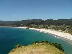
Medlands Beach
Medlands Beach is in Oruawharo Bay on the east coast of Great Barrier Island in the Auckland Region of New Zealand.[3] Auckland Council describes it as the most accessible beach on the island.[3] It is one of the island's main tourist areas but is little developed.[4] The small settlement of Medlands consists of permanent houses and holiday baches, some behind the dunes, sheltered from winds from the sea, and others elevated for a view.[3]
Medlands Beach | |
|---|---|
 Medlands Beach, seen from the Sugar Loaf hill | |
| Coordinates: 36.2658°S 175.4937°E | |
| Country | New Zealand |
| Region | Auckland Region |
| Ward | Waitematā and Gulf ward |
| Local board | Aotea / Great Barrier Local Board |
| Electorates | |
| Government | |
| • Territorial Authority | Auckland Council |
| Area | |
| • Total | 6.04 km2 (2.33 sq mi) |
| Population (June 2023)[2] | |
| • Total | 90 |
| • Density | 15/km2 (39/sq mi) |
Medlands Beach is directly south of Kaitoke Beach, with the Sugar Loaf hill and Pitokuku Island in-between. Sugar Loaf hill offers great views of the beach but is a privately owned farm with cattle and bulls and cannot be climbed without permission from the landowners - the Blackwells. Alternatively good views of the beach is offered from the road connecting Medlands to Claris. The beach is a "sweep of white sand"[4] 2.1 kilometers long that can be walked both ways in 90 minutes. Halfway along the beach is Memory Rock, also called Medlands Rock, with a short informal walking track to the summit, where there are views across the bay.[3]
At the northern end of the beach is an exposed beach surf break[5] that offers reliable surfing conditions during most of the year.[4] At the south-eastern end of the beach is Shark Alley, a sheltered spot for swimming and launching boats. It has a small stream with several pāteke (brown teal ducks)[3] and a Department of Conservation campsite which can host up to 120 people from Christmas until mid-February.[6]
The settlement has Great Barrier Island's only traditional church building, St John's Community Church, which is used ecumenically.[7] Medlands has a number of accommodation providers, but no grocery stores or food retailers. It is a 4-kilometre drive from Great Barrier Aerodrome and Claris, which has a general store, a New Zealand Post shop, a petrol station and other facilities.[4]
Demographics
Statistics New Zealand describes Medlands Beach as a rural settlement, which covers 6.04 km2 (2.33 sq mi)[1] and had an estimated population of 90 as of June 2023,[2] with a population density of 15 people per km2. Medlands Beach is part of the larger Barrier Islands statistical area.[8]
| Year | Pop. | ±% p.a. |
|---|---|---|
| 2006 | 96 | — |
| 2013 | 87 | −1.40% |
| 2018 | 75 | −2.92% |
| Source: [9] | ||
Medlands Beach had a population of 75 at the 2018 New Zealand census, a decrease of 12 people (−13.8%) since the 2013 census, and a decrease of 21 people (−21.9%) since the 2006 census. There were 48 households, comprising 48 males and 27 females, giving a sex ratio of 1.78 males per female. The median age was 53.8 years (compared with 37.4 years nationally), with 9 people (12.0%) aged under 15 years, 9 (12.0%) aged 15 to 29, 45 (60.0%) aged 30 to 64, and 15 (20.0%) aged 65 or older.
Ethnicities were 92.0% European/Pākehā, 4.0% Māori, and 4.0% other ethnicities. Percentages may add up to more than 100% as people may identify with multiple ethnicities.
Although some people chose not to answer the census's question about religious affiliation, 56.0% had no religion and 24.0% were Christian.
Of those at least 15 years old, 12 (18.2%) people had a bachelor's or higher degree, and 15 (22.7%) people had no formal qualifications. The median income was $19,700, compared with $31,800 nationally. 3 people (4.5%) earned over $70,000 compared to 17.2% nationally. The employment status of those at least 15 was that 21 (31.8%) people were employed full-time, 9 (13.6%) were part-time, and 6 (9.1%) were unemployed.[9]
Education
Kaitoke School is a coeducational full primary (years 1-8) school[10] with a roll of 42 students as of April 2023.[11] The school was established in 1988, replacing an earlier Kaitoke School.[12]
Notable Residents
Jim Allen and Pamela Allen[13] - sculptor and child's book author.
References
- "ArcGIS Web Application". statsnz.maps.arcgis.com. Retrieved 23 May 2022.
- "Subnational population estimates (RC, SA2), by age and sex, at 30 June 1996-2023 (2023 boundaries)". Statistics New Zealand. Retrieved 25 October 2023. (regional councils); "Subnational population estimates (TA, SA2), by age and sex, at 30 June 1996-2023 (2023 boundaries)". Statistics New Zealand. Retrieved 25 October 2023. (territorial authorities); "Subnational population estimates (urban rural), by age and sex, at 30 June 1996-2023 (2023 boundaries)". Statistics New Zealand. Retrieved 25 October 2023. (urban areas)
- "Medlands Beach Path". aucklandcouncil.govt.nz. Auckland Council.
- Waters, Laura (8 September 2020). "Off-grid and slow travel adventures on Great Barrier Island". New Zealand Herald. New Zealand Media and Entertainment.
- "Medlands Beach". greatbarrierisland.nz. Destination Great Barrier Island.
- "Medlands Beach Campsite". doc.govt.nz. Department of Conservation.
- "St John's Community Church, Great Barrier Island". Catholic Diocese Of Auckland. 22 November 2020. Retrieved 7 March 2021.
- 2018 Census place summary: Barrier Islands
- "Statistical area 1 dataset for 2018 Census". Statistics New Zealand. March 2020. 7001134.
- Education Counts: Kaitoke School
- "New Zealand Schools Directory". New Zealand Ministry of Education. Retrieved 12 December 2022.
- "A Bit of History". Kaitoke School. Retrieved 23 May 2022.
- "Great Barrier Island History". www.facebook.com. Retrieved 23 August 2023.