Menina Pasture Plateau
The Menina Pasture Plateau (Slovene: Menina planina) is a pre-Alpine karst plateau in Slovenia.[1]

Geography
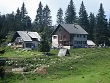
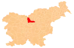
The plateau stands at an elevation between 1,200 and 1,450 meters (3,940 and 4,760 feet) in the Kamnik–Savinja Alps.[2] It is located between the Dreta Valley to the north, the Tuhinj Valley and Motnik Valley to the south, the Črnivec Pass to the west, and the Lipa Pass and Dobrovlje Plateau to the east.[2] The plateau is approximately 20 kilometers (12 mi) from east to west, and approximately 10 kilometers (6.2 mi) from north to south. The highest point on the plateau is Mount Vidovnik (1,508 meters or 4,948 feet),[1][2] where there is also a lookout tower, about a 15-minute walk from the Menina Pasture Lodge (Slovene: Dom na Menini planini; 1,508 meters or 4,948 feet).
Name
The plateau was attested in written sources in 1424 as Menino, and as Minitza in 1500. The name is believed to derive from a possessive form of the Slavic personal name *Měna. It is also possible, but less likely, that the name comes from *Mejnina planota 'border plateau', from the common noun meja 'border'.[3] Another theory derives the name from the noun menih 'monk', in connection with the former Benedictine abbey in Gornji Grad.[4][5]
References
- Veliki splošni leksikon. 1998. Vol. 5: Ma–Ož. Ljubljana: DZS, p. 2555.
- Stiplovšek, Miroslav. 1993. Menina. In: Enciklopedija Slovenije, vol. 7: Marin–Nor. Ljubljana: Mladinska knjiga, p. 69.
- Snoj, Marko (2009). Etimološki slovar slovenskih zemljepisnih imen. Ljubljana: Modrijan. p. 260.
- Menina planina. 1940. Jutro 21: 249 (October 24): 4.
- Orožen, Božena. 1972. Poučni izlet v tri doline: Savinjsko, Šaleško in Zadrečko. Jezik in slovstvo 17(7/8): 214–221, p. 219.
External links
 Media related to Menina Pasture Plateau at Wikimedia Commons
- Menina Pasture Plateau on Geopedia
