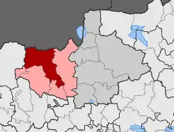
Milochori, Kilkis
Mylochori [2] or Milochori [3] (Greek: Μυλοχώρι) is a mountainous village situated in Kilkis, Central Macedonia.
Milochori
Μυλοχώρι | |
|---|---|
 Milochori Location within the regional unit  | |
| Coordinates: 41°06′54.85″N 22°53′49.03″E | |
| Country | Greece |
| Administrative region | Central Macedonia |
| Regional unit | Kilkis |
| Municipality | Kroussa |
| Elevation | 390 m (1,280 ft) |
| Community | |
| • Population | 179 (2011) |
| Time zone | UTC+2 (EET) |
| • Summer (DST) | UTC+3 (EEST) |
| Postal code | 61 100 |
| Area code(s) | +30 23410 |
| Vehicle registration | ΚΙ |
Mylochori is located on the southern slopes of Mount Dysoron (part of Kroussia ) at an altitude of 390 meters.[2] The village is 14 km away . north of the city of Kilkis and 70.5 km north of Thessaloniki.[4] To the east of the village flows the Spanos which ends in the river Gallikos. During the Turkish occupation the village was called Alexia . As a settlement it is officially mentioned in 1928 to be annexed to the then community of Antigoneia , which belonged to the prefecture of Thessaloniki . In 1934 with the Government Gazette 341A-08/10/1934 it was seconded to the newly established prefecture of Kilkis. In 1940 the name was corrected to Milochori.[3] According to the Kallikratis plan of 2010, together with Antigoneia , Gavra and Monolithi, they constitute the local community of Antigoneia, which belongs to the municipal unit of Kroussa within the municipality of Kilkis and according to the 2011 census has a population of 79 permanent residents.[5]
References
- "Απογραφή Πληθυσμού - Κατοικιών 2011. ΜΟΝΙΜΟΣ Πληθυσμός" (in Greek). Hellenic Statistical Authority.
- Enkyklopaídeia Néa Domí. Athína: Tegópoulos - Maniatéas. 1996. p. 261, tom.22.
- "Dioikitikés Metavolés Oikismón". EETAA. Retrieved 2019-02-13.
- "Évresi diadromís sto chárti, Ploígisi, Chiliometrikés apostáseis póleon | stigmap.gr". www.stigmap.gr. Retrieved 2019-02-13.
- «FEK apotelesmáton MONIMOU plithysmoú apografís 2011», sel. 10504 (sel. 40 tou pdf)