Mitiwanga, Ohio
Mitiwanga is an unincorporated community and census-designated place[3] in Erie County, Ohio, United States. It is located within Berlin and Vermilion townships, on the south shore of Lake Erie. U.S. Route 6 passes through the community, leading northeast 6 miles (10 km) to Vermilion and west 5 miles (8 km) to Huron.
Mitiwanga, Ohio | |
|---|---|
 Mitiwanga | |
| Coordinates: 41°23′2″N 82°27′52″W | |
| Country | United States |
| State | Ohio |
| County | Erie |
| Townships | Berlin, Vermilion |
| Area | |
| • Total | 0.43 sq mi (1.10 km2) |
| • Land | 0.42 sq mi (1.09 km2) |
| • Water | 0.00 sq mi (0.01 km2) |
| Elevation | 602 ft (183 m) |
| Population (2020) | |
| • Total | 326 |
| • Density | 770.69/sq mi (297.83/km2) |
| Time zone | UTC−5 (Eastern (EST)) |
| • Summer (DST) | UTC−4 (EDT) |
| ZIP Code | 44839 |
| Area code | 419/567 |
| FIPS code | 39-50974 |
| GNIS feature ID | 1065040[2] |
References
- "ArcGIS REST Services Directory". United States Census Bureau. Retrieved September 20, 2022.
- U.S. Geological Survey Geographic Names Information System: Mitiwanga, Ohio
- "Age and Sex: 2010-2014 American Community Survey 5-Year Estimates (S0101): Mitiwanga CDP, Ohio". American Factfinder. U.S. Census Bureau. Archived from the original on February 13, 2020. Retrieved March 10, 2016.
- "Census of Population and Housing". United States Census Burea. Retrieved June 4, 2016.
Municipalities and communities of Erie County, Ohio, United States | ||
|---|---|---|
| Cities | 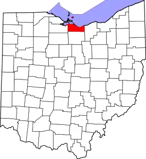 Map of Ohio highlighting Erie County | |
| Villages | ||
| Townships | ||
| CDPs | ||
| Other communities | ||
| Footnotes | ‡This populated place also has portions in an adjacent county or counties | |
This article is issued from Wikipedia. The text is licensed under Creative Commons - Attribution - Sharealike. Additional terms may apply for the media files.