Mojkovac Municipality
Mojkovac Municipality (Montenegrin and Serbian: Opština Mojkovac / Општина Мојковац) is one of the municipalities of Montenegro. The municipality is located in northeastern region of Montenegro. Administrative center of the municipality is town of Mojkovac.[1]
Mojkovac Municipality
Opština Mojkovac Општина Мојковац | |
|---|---|
 Coat of arms | |
.svg.png.webp) Mojkovac Municipality in Montenegro | |
| Country | Montenegro |
| Seat | Mojkovac |
| Area | |
| • Total | 367 km2 (142 sq mi) |
| Postal code | 84205 |
| Area code | +382 50 |
| ISO 3166-2 code | ME-11 |
| Car plates | MK |
| Website | www |
Geography and location
The municipality of Mojkovac covers an area of 367 km2 (142 sq mi) and according to the number of inhabitants (10 015 / 2003g) belongs among the smaller municipalities in Montenegro. Mojkovac is on the west bank of the Tara River, between the mountains of Bjelasica and Sinjajevina. The old mining village of Brskovo is nearby. Brskovo is one of the oldest mines in the region.
The territory of the municipality borders with municipalities: Kolašin, Šavnik, Žabljak, Bijelo Polje and Berane. Mojkovac has a station on Belgrade–Bar railway. It is also at the intersection of the main road connecting Montenegro's coast and Podgorica with northern Montenegro and Serbia (E65, E80), and the road leading towards Žabljak and Pljevlja.
Settlements
Local parliament
| Party | Seats[2] | Gov't. |
|---|---|---|
| DPS–SD–LP | 14 | No |
| Democratic Montenegro | 5 | Yes |
| Democratic Front–SNP | 8 | Yes |
| Europe Now | 2 | Yes |
| United Reform Action | 2 | Yes |
| United Montenegro | 1 | Yes |
Demographics
Town of Mojkovac is administrative centre of Mojkovac municipality, which in 2003 had a population of 10,066. The town of Mojkovac itself has 4,120 citizens.[3]
|
Ethnic groups (2011 census):[4]
|
Language (2011 census)::
|
|
Gallery
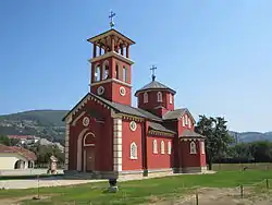
 Orthodox Church in Town of Mojkovac
 Bjelasica mountain, Mojkovac municipality
.JPG.webp) Dobrilovina Monastery near Town of Mojkovac
Dobrilovina Monastery near Town of Mojkovac Tara river, Mojkovac municipality
References
- Opštine u Crnoj Gori, Ministarstvo javne uprave (MJU), Vlada Crne Gore
- "Marković razbio opoziciju u Mojkovcu - Vijesti.me". Archived from the original on 2018-12-08. Retrieved 2019-06-23.
- Stanovništvo Crne Gore prema polu, tipu naselja, nacionalnoj, odnosno etničkoj pripadnosti, vjeroispovijesti i maternjem jeziku po opštinama u Crnoj Gori
- "Census of Population, Households and Dwellings in Montenegro 2011" (PDF). July 12, 2011.