Mokrosuky
Mokrosuky is a municipality and village in Klatovy District in the Plzeň Region of the Czech Republic. It has about 100 inhabitants.
Mokrosuky | |
|---|---|
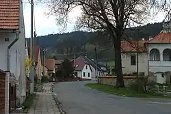 Main street | |
 Flag  Coat of arms | |
 Mokrosuky Location in the Czech Republic | |
| Coordinates: 49°16′32″N 13°27′17″E | |
| Country | |
| Region | Plzeň |
| District | Klatovy |
| First mentioned | 1418 |
| Area | |
| • Total | 6.97 km2 (2.69 sq mi) |
| Elevation | 532 m (1,745 ft) |
| Population (2023-01-01)[1] | |
| • Total | 142 |
| • Density | 20/km2 (53/sq mi) |
| Time zone | UTC+1 (CET) |
| • Summer (DST) | UTC+2 (CEST) |
| Postal code | 342 01 |
| Website | www |
Administrative parts
The village of Lešišov is an administrative part of Mokrosuky.
Geography
Mokrosuky is located about 17 kilometres (11 mi) southeast of Klatovy and 50 km (31 mi) south of Plzeň. It lies in the Bohemian Forest Foothills. The highest point is at 687 m (2,254 ft) above sea level. The Ostružná River flows through the municipality.
History
The first written mention of Mokrosuky is from 1418.[2]
Sights
The most important monument is the former Gothic water fortress from the 15th century, rebuilt in 1579 into a Renaissance castle.[2][3] Today it open to the public.[4]
The Chapel of Saint Wenceslaus dates from the end of the 18th century. At the end of the 19th century, it was reconstructed in the pseudo-Gothic style.[5]
Notable people
- Václav Vojta (1917–2000), physician
Gallery
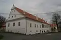 Mokrosuky Castle
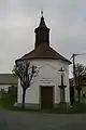 Chapel of Saint Wenceslaus
References
- "Population of Municipalities – 1 January 2023". Czech Statistical Office. 2023-05-23.
- "Historie, současnost" (in Czech). Obec Mokrosuky. Retrieved 2023-04-21.
- "Zámek" (in Czech). National Heritage Institute. Retrieved 2023-04-21.
- "Zámek Mokrosuky". Zámek Mokrosuky (in Czech). Retrieved 2023-04-21.
- "Kaple sv. Václava s pamětním křížem" (in Czech). National Heritage Institute. Retrieved 2023-04-21.