Mokvi (river)
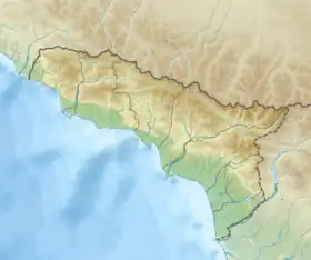
Mokvi (Abkhaz: Мықу; Georgian: მოქვი) is a river in the Ochamchira District of Abkhazia,[1] Georgia. The river's length is about 47 km and watershed — 336 km2. It forms on southern slopes of Kodori Range, at 2560 meters above sea level. River mouth with the Black Sea is near village Jukmuri. Mokvi river feeds by snow, rain and groundwater.[2]
| Mokvi | |
|---|---|
  | |
| Location | |
| Country | Georgia (Abkhazia[1]) |
| Physical characteristics | |
| Source | |
| • location | Caucasus Major |
| • coordinates | 42.9644°N 41.7664°E |
| • elevation | 2,560 m (8,400 ft) |
| Mouth | Georgia/Abkhazia[1] |
• location | Black Sea |
• coordinates | 42.7481°N 41.4139°E |
• elevation | 0 ft (0 m) |
| Length | 47 km (29 mi) |
| Basin size | 336 square kilometres (130 sq mi) |
| Discharge | |
| • average | 18 m3/s (640 cu ft/s) |
References
- The political status of Abkhazia is disputed. Having unilaterally declared independence from Georgia in 1992, Abkhazia is formally recognised as an independent state by 5 UN member states (two other states previously recognised it but then withdrew their recognition), while the remainder of the international community recognizes it as as de jure Georgian territory. Georgia continues to claim the area as its own territory, designating it as Russian-occupied territory.
- I. Apkhazava, Georgian Soviet Encyclopedia, V. 7, p. 148, Tbilisi, 1984 year.
This article is issued from Wikipedia. The text is licensed under Creative Commons - Attribution - Sharealike. Additional terms may apply for the media files.