Monte Saccarello
Monte Saccarello (Italian) or Mont Saccarel (French) is a mountain located on the French-Italian border between Liguria, Piedmont and Provence-Alpes-Côte d'Azur.
| Monte Saccarello | |
|---|---|
| French: Mont Saccarel | |
 | |
| Highest point | |
| Elevation | 2,201 m (7,221 ft)[1] |
| Prominence | 165 m (541 ft)[1][2] |
| Isolation | 3.44 km (2.14 mi) |
| Coordinates | 44°03′43″N 7°42′45″E |
| Geography | |
 Monte Saccarello Location in the Alps | |
| Location | Liguria/Piedmont, Italy - Provence-Alpes-Côte d'Azur, France |
| Parent range | Ligurian Alps |
| Climbing | |
| First ascent | ancestral |
| Easiest route | dirt road |
History
The mountain up to World War II was totally belonging to Italy but, following the Paris Peace Treaties, signed in February 1947, is now shared between Italy and France.[3]
Geography
.jpg.webp)
The mountain belongs to the Ligurian Alps; located on the main chain of the Alps, is the maximum elevation in the Italian region of Liguria.
On a sub-peak of the mountain stands a large bronze statue of Jesus Christ built in 1901.
From its north-eastern slopes rises the Tanaro.
SOIUSA classification
According to the SOIUSA (International Standardized Mountain Subdivision of the Alps) the mountain can be classified in the following way:[4]
- main part = Western Alps
- major sector = South Western Alps
- section = Ligurian Alps
- subsection = Alpi del Marguareis
- supergroup = Catena del Saccarello
- group = Gruppo del Monte Saccarello
- subgroup = Nodo del Monte Saccarello
- code = I/A-1.II-A.1.a
Environment
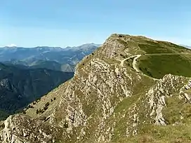
The eastern side of the mountain is gentle and grassy while the western one is a rocky and very steep.
Hiking
The mountain is accessible by mountain paths and is reached by the Alta Via dei Monti Liguri, a long-distance trail from Ventimiglia (province of Imperia) to Bolano (province of La Spezia).[5]
Mountain huts
- Rifugio Sanremo (2,054 m)
Conservation
The Ligurian side of the mountain since 2007 is included in the Parco naturale regionale delle Alpi Liguri.[6]
References
- Alpi Marittime e Liguri, 1:50.000 map n.8, I.G.C. (Turin)
- Key col: Passo Basera (2036 m)
- Trattato di pace tra Italia ed Alleati, treaty text on www.instoria.it (access-date: 2016-02-06)
- Marazzi, Sergio (2005). Atlante Orografico delle Alpi. SOIUSA (in Italian). Priuli & Verlucca. ISBN 978-88-8068-273-8.
- IM / 01 - Anello del Saccarello, web page on www.altaviadeimontiliguri.it Archived 2016-03-03 at the Wayback Machine (access: July 29, 2015)
- Parco Naturale Regionale delle Alpi Liguri, www.parks.it