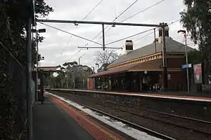
Moonee Ponds railway station
Moonee Ponds railway station is located on the Craigieburn line in Victoria, Australia. It serves the northern Melbourne suburb of Moonee Ponds, and it opened on 1 November 1860.[4]
Moonee Ponds | ||||||||||||||||||||||||||||||||||||||||||||||||||||||||||||||||||||||
|---|---|---|---|---|---|---|---|---|---|---|---|---|---|---|---|---|---|---|---|---|---|---|---|---|---|---|---|---|---|---|---|---|---|---|---|---|---|---|---|---|---|---|---|---|---|---|---|---|---|---|---|---|---|---|---|---|---|---|---|---|---|---|---|---|---|---|---|---|---|---|
| PTV commuter rail station | ||||||||||||||||||||||||||||||||||||||||||||||||||||||||||||||||||||||
 Northbound view from Platform 2 in July 2015 | ||||||||||||||||||||||||||||||||||||||||||||||||||||||||||||||||||||||
| General information | ||||||||||||||||||||||||||||||||||||||||||||||||||||||||||||||||||||||
| Location | Norwood Crescent, Moonee Ponds, Victoria 3039 City of Moonee Valley Australia | |||||||||||||||||||||||||||||||||||||||||||||||||||||||||||||||||||||
| Coordinates | 37°45′57″S 144°55′10″E | |||||||||||||||||||||||||||||||||||||||||||||||||||||||||||||||||||||
| Owned by | VicTrack | |||||||||||||||||||||||||||||||||||||||||||||||||||||||||||||||||||||
| Operated by | Metro Trains | |||||||||||||||||||||||||||||||||||||||||||||||||||||||||||||||||||||
| Line(s) | Craigieburn | |||||||||||||||||||||||||||||||||||||||||||||||||||||||||||||||||||||
| Distance | 6.89 kilometres from Southern Cross | |||||||||||||||||||||||||||||||||||||||||||||||||||||||||||||||||||||
| Platforms | 2 side | |||||||||||||||||||||||||||||||||||||||||||||||||||||||||||||||||||||
| Tracks | 2 | |||||||||||||||||||||||||||||||||||||||||||||||||||||||||||||||||||||
| Connections |
| |||||||||||||||||||||||||||||||||||||||||||||||||||||||||||||||||||||
| Construction | ||||||||||||||||||||||||||||||||||||||||||||||||||||||||||||||||||||||
| Structure type | Ground | |||||||||||||||||||||||||||||||||||||||||||||||||||||||||||||||||||||
| Parking | 107 | |||||||||||||||||||||||||||||||||||||||||||||||||||||||||||||||||||||
| Bicycle facilities | Yes | |||||||||||||||||||||||||||||||||||||||||||||||||||||||||||||||||||||
| Accessible | No—steep ramp | |||||||||||||||||||||||||||||||||||||||||||||||||||||||||||||||||||||
| Other information | ||||||||||||||||||||||||||||||||||||||||||||||||||||||||||||||||||||||
| Status | Operational, host station | |||||||||||||||||||||||||||||||||||||||||||||||||||||||||||||||||||||
| Station code | MPD | |||||||||||||||||||||||||||||||||||||||||||||||||||||||||||||||||||||
| Fare zone | Myki Zone 1 | |||||||||||||||||||||||||||||||||||||||||||||||||||||||||||||||||||||
| Website | Public Transport Victoria | |||||||||||||||||||||||||||||||||||||||||||||||||||||||||||||||||||||
| History | ||||||||||||||||||||||||||||||||||||||||||||||||||||||||||||||||||||||
| Opened | 1 November 1860 | |||||||||||||||||||||||||||||||||||||||||||||||||||||||||||||||||||||
| Closed | 1 July 1864 | |||||||||||||||||||||||||||||||||||||||||||||||||||||||||||||||||||||
| Rebuilt | 9 October 1871 | |||||||||||||||||||||||||||||||||||||||||||||||||||||||||||||||||||||
| Electrified | May 1919 (1500 V DC overhead) | |||||||||||||||||||||||||||||||||||||||||||||||||||||||||||||||||||||
| Passengers | ||||||||||||||||||||||||||||||||||||||||||||||||||||||||||||||||||||||
| 2005–2006 | 614,106[1] | |||||||||||||||||||||||||||||||||||||||||||||||||||||||||||||||||||||
| 2006–2007 | 675,538[1] | |||||||||||||||||||||||||||||||||||||||||||||||||||||||||||||||||||||
| 2007–2008 | 817,206[1] | |||||||||||||||||||||||||||||||||||||||||||||||||||||||||||||||||||||
| 2008–2009 | 823,669[2] | |||||||||||||||||||||||||||||||||||||||||||||||||||||||||||||||||||||
| 2009–2010 | 852,833[2] | |||||||||||||||||||||||||||||||||||||||||||||||||||||||||||||||||||||
| 2010–2011 | 810,650[2] | |||||||||||||||||||||||||||||||||||||||||||||||||||||||||||||||||||||
| 2011–2012 | 812,272[2] | |||||||||||||||||||||||||||||||||||||||||||||||||||||||||||||||||||||
| 2012–2013 | Not measured[2] | |||||||||||||||||||||||||||||||||||||||||||||||||||||||||||||||||||||
| 2013–2014 | 782,344[2] | |||||||||||||||||||||||||||||||||||||||||||||||||||||||||||||||||||||
| 2014–2015 | 764,452[1] | |||||||||||||||||||||||||||||||||||||||||||||||||||||||||||||||||||||
| 2015–2016 | 853,784[2] | |||||||||||||||||||||||||||||||||||||||||||||||||||||||||||||||||||||
| 2016–2017 | 860,108[2] | |||||||||||||||||||||||||||||||||||||||||||||||||||||||||||||||||||||
| 2017–2018 | 861,193[2] | |||||||||||||||||||||||||||||||||||||||||||||||||||||||||||||||||||||
| 2018–2019 | 858,700[2] | |||||||||||||||||||||||||||||||||||||||||||||||||||||||||||||||||||||
| 2019–2020 | 776,300[2] | |||||||||||||||||||||||||||||||||||||||||||||||||||||||||||||||||||||
| 2020–2021 | 362,450[2] | |||||||||||||||||||||||||||||||||||||||||||||||||||||||||||||||||||||
| 2021–2022 | 436,200[3] | |||||||||||||||||||||||||||||||||||||||||||||||||||||||||||||||||||||
| Services | ||||||||||||||||||||||||||||||||||||||||||||||||||||||||||||||||||||||
| ||||||||||||||||||||||||||||||||||||||||||||||||||||||||||||||||||||||
| ||||||||||||||||||||||||||||||||||||||||||||||||||||||||||||||||||||||
History
Moonee Ponds station opened on 1 November 1860, just over a week after the railway line opened as part of the private Melbourne and Essendon Railway Company line to Essendon. The station closed with the line on 1 July 1864, but was reopened on 9 October 1871, under government ownership.[5] Like the suburb itself, the station is believed to have gotten its name from either the Moonee Ponds Creek, which resembled a chain of ponds in dry weather (the creek was noted as "Mone Mone Creek" in 1837 by government surveyor Robert Hoddle, during a survey of the area), an Indigenous Australian who was attached to the mounted police, or John Moonee, who had land near the present day Moonee Valley Racecourse.[6][7]
In 1882, the station building on Platform 1 was provided, with a signal box provided in 1889 to control interlocked gates at the Puckle Street level crossing. In 1969, these gates were replaced with boom barriers.[5]
On 4 May 2010, as part of the 2010/2011 State Budget, $83.7 million was allocated to upgrade Moonee Ponds to a premium station, along with nineteen others.[8][9] However, in March 2011, this was scrapped by the Baillieu Government.[10]
Platforms and services
Moonee Ponds has two side platforms. It is serviced by Metro Trains' Craigieburn line services.[11]
Platform 1:
- Craigieburn line all stations services to Flinders Street
Platform 2:
- Craigieburn line all stations services to Craigieburn
Transport links
Ryan Brothers Bus Service operates one route to and from Moonee Ponds station, under contract to Public Transport Victoria:
- 467 : to Aberfeldie[12]
Moonee Ponds Junction is located 400 metres east of the station, and is the terminus for routes operated by CDC Melbourne, Dysons, Kastoria Bus Lines, Moonee Valley Coaches and Transit Systems Victoria. It is also served by Yarra Trams routes ![]() and
and ![]() .
.
Gallery
 Southbound view from Platform 2 in November 2008
References
- Estimated Annual Patronage by Network Segment Financial Year 2005-2006 to 2018-19 Department of Transport
- Railway station and tram stop patronage in Victoria for 2008-2021 Philip Mallis
- Annual metropolitan train station patronage (station entries) Data Vic
- "Moonee Ponds". vicsig.net. Retrieved 12 February 2023.
- Turton, Keith W (1973). Six And A Half Inches From Destiny. The first hundred years of the Melbourne-Wodonga Railway 1873-1973. Australian Railway Historical Society. pp. 23, 86. ISBN 0-85849-012-9.
- "Moonee Ponds". Victorian Places. Retrieved 12 February 2023.
- First, Jamie (7 January 2014). "The A-Z story of Melbourne's suburbs". Herald Sun. Retrieved 12 February 2023.
- "New premium stations for Metro". Sydney Morning Herald. 4 May 2010. Retrieved 19 February 2023.
- "General News". Newsrail. Australian Railway Historical Society. June 2010. p. 165.
- Gardiner, Ashley; Wright, Anne (25 March 2011). "Premier Ted Baillieu says armed guards will create 'culture of safety'". Herald Sun. Retrieved 19 February 2023.
- "Craigieburn Line". Public Transport Victoria.
- "467 Aberfeldie - Moonee Ponds via Holmes Road". Public Transport Victoria.
External links
- Melway map at street-directory.com.au