Morombe (district)
Morombe is a district of Atsimo-Andrefana in Madagascar.[1][2] It can be reached by the National road 55 or pirogue from Morondava. It is situated at 283 km from Tulear.[3]
Morombe (district) | |
|---|---|
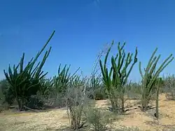
 a Didierea in Andombiry, Morombe | |
 Morombe (district) Location in Madagascar | |
| Coordinates: 21°45′S 43°22′E | |
| Country | |
| Region | Atsimo-Andrefana |
| District | Morombe |
| Elevation | 7 m (23 ft) |
| Population (2018)Census | |
| • Ethnicities | Vezo |
| Time zone | UTC3 (EAT) |
| Postal code | 618 |
An airport serves the town.
Television
For 17 years now there is no television available in Morombe. At the time the transmitter broke down, the director took it to Tulear and later to Antananarivo but it was never returned.[4]
Municipalities
The district is further divided into eight municipalities:
Baobab d'Andombiry

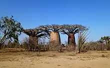
Three Brothers Baobab in Andombiry, Morombe
The largest baobab in this world is found in the village of Belintsaka, 23 km from Morombe. It has a circumference of almost 28m. There are more than 6000 adult baobabs alone in the forest of Andombiry of which 30 specimen are very large, with a circumference of more than 20m.[5]
See also
- Morondava
- Kirindy Mitea National Park
- Mikea Forest
- Roman Catholic Diocese of Morombe
- Andavadoaka, a village of this district
References
- REPOBLIKAN’I MADAGASIKARA:Tanindrazana – Fahafahana – Fandrosoana (PDF). MINISTERE DE L’AGRICULTURE, DE L’ELEVAGE ET DE LA PECHE. October 2007. pp. 42–44. Archived from the original (PDF) on 2018-06-12. Retrieved 2018-06-09.
- "Madagascar: Administrative Division". citypopulation. Retrieved 10 June 2018.
- Contextualisation sociale et Energie renouvelable, cas de la commune urbaine de Morombe
- Communication: Morombe prié de RNM depuis 17 ans
- Monumental Trees.com
This article is issued from Wikipedia. The text is licensed under Creative Commons - Attribution - Sharealike. Additional terms may apply for the media files.
