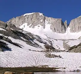
Mount Abbot
Mount Abbot is a mountain in California's Sierra Nevada, in the John Muir Wilderness.[6] It is located between Mount Mills and Mount Dade along the Sierra Crest and straddles the border between Fresno and Inyo counties.
| Mount Abbot | |
|---|---|
 Mount Abbot, showing the north couloir. Petit Griffon is the gendarme on the right. | |
| Highest point | |
| Elevation | 13,710 ft (4,180 m) NAVD 88[1] |
| Prominence | 864 ft (263 m)[1] |
| Listing | |
| Coordinates | 37°23′11″N 118°47′05″W[4] |
| Geography | |
 Mount Abbot  Mount Abbot | |
| Location | Fresno / Inyo counties, California, U.S. |
| Parent range | Sierra Nevada |
| Topo map | USGS Mount Abbot |
| Climbing | |
| First ascent | July 13, 1908 by Joseph N. Le Conte, James S. Hutchinson & Duncan McDuffie[5] |
| Easiest route | Exposed scramble, class 3[2] |
The peak was named for Henry Larcom Abbot who, in 1855, was a member of the Williamson party of the Pacific Railroad Surveys in California and Oregon.[5][7] He retired from the United States Army as a brigadier general in 1904.[5]
_2.jpg.webp)
Sky pilot on Mount Abbot at about 13,000 feet
See also
References
- "Mount Abbot, California". Peakbagger.com. Retrieved 2009-01-16.
- "Sierra Peaks Section List" (PDF). Angeles Chapter, Sierra Club. Retrieved 2009-01-16.
- "Western States Climbers Qualifying Peak List". Retrieved 2016-03-24.
- "Mount Abbot". Geographic Names Information System. United States Geological Survey, United States Department of the Interior. Retrieved 2009-01-16.
- Farquhar, Francis P. (1926). Place Names of the High Sierra. San Francisco: Sierra Club. Retrieved 2009-01-16.
- "Mount Abbot". SummitPost.org. Retrieved 2011-05-31.
- Erwin G. Gudde; William Bright (10 May 2004). California Place Names: The Origin and Etymology of Current Geographical Names. University of California Press. p. 3. ISBN 978-0-520-24217-3. Retrieved 2012-04-01.
This article is issued from Wikipedia. The text is licensed under Creative Commons - Attribution - Sharealike. Additional terms may apply for the media files.