Mount Alma, Queensland
Mount Alma is a rural locality in the Gladstone Region, Queensland, Australia.[2] In the 2016 census, Mount Alma had a population of 47 people.[1]
| Mount Alma Queensland | |||||||||||||||
|---|---|---|---|---|---|---|---|---|---|---|---|---|---|---|---|
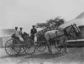
 People in a four wheel carriage, Mount Alma Station, 1890s | |||||||||||||||
 Mount Alma | |||||||||||||||
| Coordinates | 24.0905°S 150.8755°E | ||||||||||||||
| Population | 47 (2016 census)[1] | ||||||||||||||
| • Density | 0.0578/km2 (0.1496/sq mi) | ||||||||||||||
| Postcode(s) | 4680 | ||||||||||||||
| Area | 813.5 km2 (314.1 sq mi) | ||||||||||||||
| Time zone | AEST (UTC+10:00) | ||||||||||||||
| Location |
| ||||||||||||||
| LGA(s) | Gladstone Region | ||||||||||||||
| State electorate(s) | Callide | ||||||||||||||
| Federal division(s) | Flynn | ||||||||||||||
| |||||||||||||||
Geography
The locality is bounded by the Mount Alma Range to the north, the Calliope Range to the west and south-west, and the Boyne Range to the south-east.[3]
The Calliope River rises in the north-west of the locality (23.96086°S 150.69654°E) flowing south-east towards the centre of the locality and then flows north-east to exit the locality to the east (Wooderson).[3]
Upper Calliope is a neighbourhood within the north-east of the locality (24.0333°S 150.9666°E).[4]
Mount Alma has the following mountains:
- Cedric Mountain (23.9490°S 150.7133°E) 699 metres (2,293 ft)[5][6]
- Fig Tree Hill (24.0376°S 150.7182°E) 830 metres (2,720 ft)[5][7]
- Mount Grim (24.0221°S 150.8209°E) 229 metres (751 ft)[5][8]
- Mount Harper (24.0085°S 150.8871°E) 238 metres (781 ft)[5][9]
- Mount Redshirt (24.0849°S 150.7316°E) 597 metres (1,959 ft)[5][10]
- Round Mountain (24.1227°S 150.7257°E) 487 metres (1,598 ft)[5][11]
- The Mole Hill (24.1221°S 150.7476°E) 207 metres (679 ft)[5][12]
The Dawson Highway enters the locality from the east (Wooderson) and exits to the south-west (Dumgree).[3]
The Moura railway line also enters the locality from the east (Wooderson) and exits to the south-west (Dumgree) with the locality being served by:
- Clarke railway station (24.0652°S 150.9127°E)[13]
- Fry railway station (24.0880°S 150.8216°E)[13]
In the south of the locality are two protected areas:
- Maxwelton State Forest, 1,697 hectares (4,190 acres) at 24.2145°S 150.8600°E
- northern section of Kroombit Tops National Park at 24.2467°S 150.9118°E
Apart from the protected areas, the predominant land use is grazing on native vegetation with a small area of production forestry in the south-west of the locality.[3]
History
Calliope Station Provisional School opened in March 1912 as a half time school in conjunction with Mount Redshirt Provisional School (meaning they shared a teacher). In 1917 it became a full time provisional school. On 1 August 1922 it became Calliope Station State School. It closed on 8 July 1956.[14] It was at 44 Galloway Plains Road (24.0306°S 150.9624°E).[15][3]
In the 2016 census, Mount Alma had a population of 47 people.[1]
Economy
There are a number of homesteads in the locality:[16]
- Bocoolima (24.1783°S 150.9156°E)
- Colenso (24.0466°S 150.7684°E)
- Galloway Plains (24.1204°S 150.9688°E)
- Mount Alma (24.0236°S 150.8712°E)
- Rockfield (24.1162°S 150.8080°E)
- Upper Calliope (24.0251°S 150.9677°E)
- Wyalla (24.1229°S 150.7571°E)
Education
There are no schools in Mount Alma. The nearest government primary schools are Mount Larcom State School in Mount Larcom to the north, Calliope State School in Calliope to the east, and Mount Murchison State School in Mount Murchison to the south-west. The nearest government secondary schools are Calliope State High School (to Year 10) in Calliope to the east, Gladstone State High School (to Year 12) in South Gladstone to the north-east, and Biloela State High School (to Year 12) in Biloela to the south-west. There are some parts of Mount Alma too distant from these schools; distance education or boarding school would be other options.[3]
References
- Australian Bureau of Statistics (27 June 2017). "Mount Alma (SSC)". 2016 Census QuickStats. Retrieved 20 October 2018.
- "Mount Alma – locality in Gladstone Region (entry 46613)". Queensland Place Names. Queensland Government. Retrieved 27 December 2020.
- "Queensland Globe". State of Queensland. Retrieved 22 January 2022.
- "Upper Calliope – locality unbounded in Gladstone Regional (entry 35821)". Queensland Place Names. Queensland Government. Retrieved 27 December 2020.
- "Mountain peaks and capes - Queensland". Queensland Open Data. Queensland Government. 12 November 2020. Archived from the original on 25 November 2020. Retrieved 25 November 2020.
- "Cedric Mountain – mountain in Gladstone Region (entry 6759)". Queensland Place Names. Queensland Government. Retrieved 25 November 2020.
- "Fig Tree Hill – mountain in Gladstone Region (entry 12399)". Queensland Place Names. Queensland Government. Retrieved 25 November 2020.
- "Mount Grim – mountain in Gladstone Region (entry 14895)". Queensland Place Names. Queensland Government. Retrieved 25 November 2020.
- "Mount Harper – mountain in Gladstone Region (entry 15416)". Queensland Place Names. Queensland Government. Retrieved 25 November 2020.
- "Mount Redshirt – mountain in Gladstone Region (entry 28283)". Queensland Place Names. Queensland Government. Retrieved 25 November 2020.
- "Round Mountain – mountain in Gladstone Region (entry 29176)". Queensland Place Names. Queensland Government. Retrieved 25 November 2020.
- "The Mole Hill – mountain in Gladstone Region (entry 34025)". Queensland Place Names. Queensland Government. Retrieved 25 November 2020.
- "Railway stations and sidings - Queensland". Queensland Open Data. Queensland Government. 2 October 2020. Archived from the original on 5 October 2020. Retrieved 5 October 2020.
- Queensland Family History Society (2010), Queensland schools past and present (Version 1.01 ed.), Queensland Family History Society, ISBN 978-1-921171-26-0
- "Queensland Two Mile series sheet 2m201" (Map). Queensland Government. 1954. Archived from the original on 3 May 2021. Retrieved 22 January 2022.
- "Homesteads - Queensland". Queensland Open Data. Queensland Government. 18 November 2020. Archived from the original on 24 November 2020. Retrieved 24 November 2020.