Mount Andrus
Mount Andrus is a shield volcano 3.2 km (2 mi) SE of Mount Boennighausen in the SE extremity of Ames Range, in Marie Byrd Land, Antarctica. Mapped by USGS from surveys and U.S. Navy air photos, 1964–68. Named by US-ACAN for Lt. Carl H. Andrus, US Navy, medical officer and Officer-in-Charge of Byrd Station in 1964.[1]
| Mount Andrus | |
|---|---|
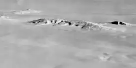 Aerial view of the Ames Range. Mount Andrus is the first mount from the left, excluding Mount Berlin, which can be seen isolated far away | |
| Highest point | |
| Elevation | 2,978 m (9,770 ft) |
| Coordinates | 75°48′0″S 132°18′0″W |
| Geography | |
 Mount Andrus | |
| Parent range | Ames Range |
| Geology | |
| Age of rock | middle Miocene - Holocene |
| Mountain type | Shield volcano |
| Volcanic field | Marie Byrd Land Volcanic Province |
| Last eruption | Unknown |
Andrus has a 4.5 km-wide caldera at its summit.[1] The westward face of the mountain is drained by the Coleman Glacier, with significant crevassing present. While the age of Mt. Andrus is not well known it is one of the oldest trachytic shield volcanoes in Marie Byrd Land, similar in age to Mount Hampton.[1]
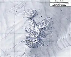
Topographic map of the Ames Range (1:250,000 scale) from USGS Mount Kosciusko
See also
References
- Le Masurier, W. E. (1990). "B. 12. Ames Range". In Le Masurier, W. E.; Thomson, J.W. (eds.). Volcanoes of the Antarctic Plate and Southern Oceans. Antarctic Research Series vol 48. Washington, DC: American Geophysical Union. pp. 216–220. doi:10.1029/AR048. ISBN 9781118664728.
External links
- https://web.archive.org/web/20051030114935/http://usarc.usgs.gov/antarctic_atlas/
- http://www.skimountaineer.com/
This article is issued from Wikipedia. The text is licensed under Creative Commons - Attribution - Sharealike. Additional terms may apply for the media files.