Mouresi
Mouresi (Greek: Μουρέσι) is a village and a former municipality in Magnesia, Thessaly, Greece. It is situated in the northeastern part of the Pelion peninsula. Since the 2011 local government reform it is part of the municipality Zagora-Mouresi, of which it is a municipal unit.[2] The municipal unit has an area of 54.214 km2.[3] The seat of the municipality was in Tsagkarada. In 2011 the population of the village Mouresi was 485, that of the community Mouresi was 548, and of the municipal unit 2,475.[1]
Mouresi
Μουρέσι | |
|---|---|
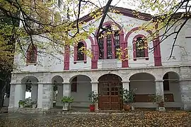
 Mouresi, Agia Triada church | |
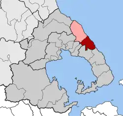
 Mouresi Location within the regional unit  | |
| Coordinates: 39°24′N 23°10′E | |
| Country | Greece |
| Administrative region | Thessaly |
| Regional unit | Magnesia |
| Municipality | Zagora-Mouresi |
| • Municipal unit | 54.2 km2 (20.9 sq mi) |
| Highest elevation | 800 m (2,600 ft) |
| Lowest elevation | 0 m (0 ft) |
| Population (2011)[1] | |
| • Municipal unit | 2,475 |
| • Municipal unit density | 46/km2 (120/sq mi) |
| Community | |
| • Population | 548 (2011) |
| Time zone | UTC+2 (EET) |
| • Summer (DST) | UTC+3 (EEST) |
| Postal code | 370 12 |
| Area code(s) | 24230 |
| Vehicle registration | ΒΟ (Beta Omicron) |
Subdivisions
The municipal unit Mouresi is subdivided into the following communities (constituent villages in brackets):
- Agios Dimitrios Piliou (Agios Dimitrios, Agios Ioannis)
- Anilio (Anilio, Plaka)
- Kissos
- Mouresi (Mouresi, Agios Ioannis, Damouchari)
- Tsagkarada (Tsagkarada, Mylopotamos)
- Xorychti (Xorychti, Kato Xorychti)
Geography
The municipal unit Mouresi covers the northeastern part of the Pelion peninsula, and is situated on the eastern side of the Pelion mountains, on the Aegean Sea coast. The area is mountainous and densely forested. The largest village is Tsagkarada (population 525 in 2011). The village Mouresi lies at 310 m elevation, 1.5 km northwest of Tsagkarada, 2 km southeast of Agios Dimitrios and 7 km southeast of Zagora.
Historical population
| Year | Community | Municipal unit |
|---|---|---|
| 1991 | - | 3,239 |
| 2001 | 588 | 3,107 |
| 2011 | 548 | 2,475 |
References
- "Απογραφή Πληθυσμού - Κατοικιών 2011. ΜΟΝΙΜΟΣ Πληθυσμός" (in Greek). Hellenic Statistical Authority.
- "ΦΕΚ B 1292/2010, Kallikratis reform municipalities" (in Greek). Government Gazette.
- "Population & housing census 2001 (incl. area and average elevation)" (PDF) (in Greek). National Statistical Service of Greece.