Muaro Jambi Regency
Muaro Jambi Regency is a regency of Jambi Province, Sumatra, Indonesia. It was created on 4 October 1999 by the separation of what were formerly the eastern districts of Batang Hari Regency. It surrounds the major city of Jambi, the provincial capital, and includes many of the expanding suburbs of Jambi outside the city boundaries; consequently it has experienced population growth greater than elsewhere in the province. From the 4th until the 13th century, it was the seat of the Hindu-Buddhist Melayu Kingdom. It has an area of 5,246.00 km2 and had a population of 342,952 at the 2010 census[2] and 390,347 at the 2020 census;[3] the official estimate as at mid 2022 is 412,830 (comprising 212,776 males and 200,054 females).[1]
Muaro Jambi Regency
(Kabupaten Muaro Jambi) | |
|---|---|
 | |
 Coat of arms | |
| Motto: Sailun Salimbai | |
 | |
| Country | Indonesia |
| Province | Jambi |
| Regency seat | Sengeti |
| Area | |
| • Total | 5,246.00 km2 (2,025.49 sq mi) |
| Population (mid 2022 estimate)[1] | |
| • Total | 412,830 |
| • Density | 79/km2 (200/sq mi) |
| Time zone | UTC+7 (WIB) |
| Website | muarojambikab.go.id |
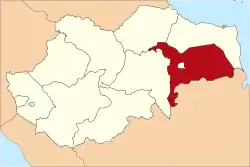
Administrative districts
At the time of the 2010 census, the regency was divided into eight districts (kecamatan): Jambi Luar Kota (Jambi city's suburbs), Kumpeh, Kumpeh Ulu, Maro Sebo, Mestong, Sekernan, Sungai Bahar (Bahar River) and Sungai Gelam (Gelam River). Subsequently, another three districts have been added by splitting away from existing districts - Bahar Selatan (South Bahar), Bahar Utara (North Bahar) and Taman Rajo.
These eleven districts are tabulated below with their areas and their populations at the 2010 census[2] and the 2020 census,[3] together with the official estimates as at mid 2022.[1] The table also includes the locations of the district administrative centres, and the number of administrative villages in each district (a total of 150 rural desa and 5 urban kelurahan).
| Name of District (kecamatan) | Area in km2 | Pop'n 2010 census | Pop'n 2020 census | Pop'n mid 2022 estimate | Admin centre | No. of villages |
|---|---|---|---|---|---|---|
| Mestong | 474.70 | 37,490 | 39,553 | 41,050 | Sebapo | 15 |
| Sungai Bahar | 160.50 | 51,170 | 28,381 | 29,040 | Marga Manunggal Jaya | 11 |
| Bahar Selatan | 195.69 | (a) | 16,226 | 16,740 | Tanjung Mulya | 10 |
| Bahar Utara | 167.26 | (a) | 13,522 | 13,920 | Talang Bukit | 11 |
| Kumpeh Ulu | 386.65 | 45,991 | 56,999 | 60,660 | Pudak | 18 |
| Sungai Gelam | 654.41 | 57,276 | 65,951 | 72,580 | Sungai Gelam | 15 |
| Kumpeh | 1,658.93 | 24,712 | 24,595 | 25,130 | Tanjung Mulya | 17 |
| Maro Sebo | 261.47 | 28,179 | 21,268 | 22,020 | Jambi Kecil | 12 |
| Taman Rajo | 352.67 | (b) | 13,117 | 13,570 | Kemingking Dalam | 10 |
| Jambi Luar Kota ("Jambi outside the city") | 280.12 | 58,380 | 65,305 | 71,830 | Pijoan | 20 |
| Sekernan | 671.60 | 39,754 | 45,330 | 46,290 | Sengeti | 16 |
| Totals | 5,264.00 | 342,952 | 390,347 | 412,830 | Sengeti | 155 |
Note: (a) The 2010 population of the new Bahar Selatan and Bahar Utara districts are included with that of the existing Sungai Bahar District, from which they were cut out.
(b) The 2010 population of the new Taman Rajo District is included with that of the existing Maro Sebo District, from which it was cut out.
Archaeology
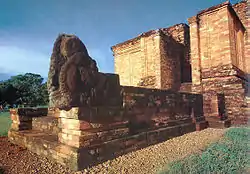
Located within this regency, the Muaro Jambi Temple Compounds is one of the largest archaeological complex in Sumatra. The archaeological site is located some 22 km downstream from the modern capital, on the opposite bank, it has the ancient Hindu Candi and Menapo or brick-built temples and canals. Restoration of three main structures Candi Tinggi, Candi Gumpung and Candi Kedaton, the last with an unusual fill of small white river pebbles, has been completed.
See also
References
- Badan Pusat Statistik, Jakarta, 2023, Kabupaten Muaro Jambi Dalam Angka 2023 (Katalog-BPS 1102001.1505)
- Biro Pusat Statistik, Jakarta, 2011.
- Badan Pusat Statistik, Jakarta, 2021.
External links
- Muarojambi Temple Compound - UNESCO world heritage tentative list
- https://web.archive.org/web/20100521045224/http://inspirasipakde.com/2009/02/17/journey-to-the-past/
- https://web.archive.org/web/20140823075620/http://jambi.bebasnews.com/