Sarolangun Regency
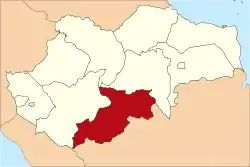
Sarolangun Regency is a regency of Jambi Province, Indonesia. It is located on the island of Sumatra. It was created on 4 October 1999 by the division of the former Sarolangun Bangko Regency into a new Merangin Regency and this Sarolangun Regency. The regency has an area of 5,941.13 km2 and had a population of 246,245 at the 2010 census[2] and 290,047 at the 2020 census;[3] the official estimate as at mid 2022 was 298,091 (comprising 152,133 males and 145,958 females).[1] The administrative centre is at the town of Sarolangun.
Sarolangun Regency
(Kabupaten Sarolangun) | |
|---|---|
 | |
 Coat of arms | |
| Motto: Sepucuk Adat Serumpun Pseko | |
 | |
| Country | Indonesia |
| Province | Jambi |
| Regency seat | Sarolangun |
| Area | |
| • Total | 6,174 km2 (2,384 sq mi) |
| Population (mid 2022 estimate)[1] | |
| • Total | 298,091 |
| • Density | 48/km2 (130/sq mi) |
| Time zone | UTC+7 (WIB) |
| Website | sarolangunkab.go.id |
Administrative districts
At the 2020 Census, Sarolangun Regency comprised ten districts (kecamatan), but in 2022 a new Mandiangin Timur (East Mandiangin) District was created from the eastern part of Mandiangin District. The eleven districts are tabulated below with their areas and their populations at the 2010 census[2] and 2020 census,[3] together with the official estimates as at mid 2022.[1] The table also includes the locations of the district administrative centres, the number of administrative villages in each district (a total of 149 rural desa and 9 urban kelurahan), and its post code.
| Name of District (kecamatan) | Area in km2 | Pop'n 2010 census | Pop'n 2020 census | Pop'n mid 2022 estimate | Admin centre | No. of villages | Post code |
|---|---|---|---|---|---|---|---|
| Batang Asai | 926.79 | 16,036 | 18,705 | 19,184 | Pekan Gedang | 23 | 37485 |
| Limun | 807.11 | 15,343 | 18,118 | 18,626 | Pulau Pandan | 16 | 37382 |
| Cermin Nan Gedang | 385.46 | 10,858 | 13,474 | 13,985 | Lubuk Resam | 10 | 37381 |
| Pelawan | 347.44 | 28,138 | 34,224 | 35,386 | Pelawan | 14 | 37482 |
| Singkut | 209.78 | 36,184 | 40,198 | 40,840 | Sungai Benteng | 13 (a) | 37483 |
| Saronangun (district) | 281.07 | 46,098 | 56,900 | 58,999 | Sarolangun | 16 (b) | 37481 |
| Bathin VIII | 360.84 | 18,031 | 21,155 | 21,721 | Limbur Tembesi | 15 (a) | 37480 |
| Pauh | 759.40 | 20,566 | 24,132 | 24,778 | Pauh | 14 (a) | 37491 |
| Air Hitam | 634.84 | 23,757 | 26,011 | 26,352 | Jernih | 9 | 37490 |
| Mandiangin | 748.74 | 31,234 | 37,130 | 24,547 | Mandiangin | 18 | 37492 |
| Mandiangin Timur | 479.66 | (c) | (c) | 13,673 | Butang Baru | 10 | 37492 |
| Totals | 5,941.13 | 246,245 | 290,047 | 298,091 | Sarolangun | 158 |
Notes: (a) includes one kelurahan. (b) includes six kelurahan. (c) the 2010 and 2020 figures for the new Mandiangin Timur District are included in the totals for Mandiangin District.
References
- Badan Pusat Statistik, Jakarta, 2023, Kabupaten Sarolangun Dalam Angka 2023 (Katalog-BPS 1102001.1503)
- Biro Pusat Statistik, Jakarta, 2011.
- Badan Pusat Statistik, Jakarta, 2021.