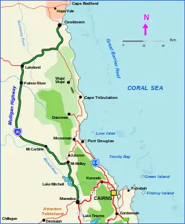
Mulligan Highway
The Mulligan Highway is a state highway in Queensland, Australia. It runs for approximately 266 km between Mareeba and Cooktown, on the east coast of Cape York Peninsula where it terminates. It is signed as State Route 81 from Mareeba to Lakeland and State Route 40 from Lakeland to Cooktown.[1] It is a state-controlled regional road (numbers 34A, 34B and 34C).[2][3]
Mulligan Highway Formerly Cooktown Developmental Road | |
|---|---|
 | |
| Mulligan Highway (green on black) | |
| General information | |
| Type | Highway |
| Length | 266 km (165 mi) |
| Route number(s) | |
| Major junctions | |
| South end | |
| North end | |
| Location(s) | |
| Major settlements | Mount Molloy, Lakeland |
| Highway system | |
Named after bushman James Venture Mulligan the sealed highway follows the old Cooktown Developmental Road and was completed in 2006. Since it was sealed, travelling time from Cairns to Cooktown has reduced from 6 to 3½ hours.
List of towns along the highway
Linked state-controlled roads
In addition to the Peninsula Developmental Road, the following state-controlled roads are linked to this road:
- Mareeba-Dimbulah Road
- Mossman-Mount Molloy Road
Mareeba–Dimbulah Road
Mareeba–Dimbulah Road
| |
|---|---|
| Location | Mulligan Highway, Mareeba to Burke Developmental Road, Dimbulah |
| Length | 44.5 km (27.7 mi) |
| Route number | 27 |
Mareeba–Dimbulah Road is a state-controlled regional road (number 664).[2][3] It starts at an intersection with Mulligan Highway (State Route 81) in Mareeba. It runs south-west as State Route 27, for 44.5 kilometres (27.7 mi) to Dimbulah, where it transitions to Burke Developmental Road. The road has no major intersections .[4]
Major intersections
| LGA | Location | km | mi | Destinations | Notes |
|---|---|---|---|---|---|
| Mareeba | Mareeba | 0 | 0.0 | Southern end of Mulligan Highway (State Route 81) | |
| 3.3 | 2.1 | ||||
| Mount Molloy | 43.5 | 27.0 | |||
| Cook | Lakeland | 187 | 116 | State Route 81 continues north-west as Peninsula Developmental Road. Mulligan Highway continues north-east as State Route 40. | |
| Cooktown | 266 | 165 | Charlotte Street - north - Cooktown CBD | Northern end of Mulligan Highway | |
1.000 mi = 1.609 km; 1.000 km = 0.621 mi
| |||||
References
- Hema, Maps (2007). Australia Road and 4WD Atlas (Map). Eight Mile Plains Queensland: Hema Maps. pp. 13–14. ISBN 978-1-86500-456-3.
- "North Queensland Region map" (PDF). Department of Transport and Main Roads ©State of Queensland [CC BY 4.0]. 2020. Retrieved 7 July 2023.
- "Far North District map" (PDF). Department of Transport and Main Roads ©State of Queensland [CC BY 4.0]. 2020. Retrieved 7 July 2023.
- Google (18 July 2023). "Mareeba to Dimbulah" (Map). Google Maps. Google. Retrieved 18 July 2023.