Munith, Michigan
Munith is an unincorporated community in northeast Jackson County in the U.S. state of Michigan. It is located along M-106 on the boundary between Waterloo Township and Henrietta Township at 42°23′26″N 84°15′02″W.[1]
Munith, Michigan | |
|---|---|
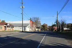 Looking north along Main Street | |
 Munith Location within the state of Michigan  Munith Munith (the United States) | |
| Coordinates: 42°23′26″N 84°15′02″W | |
| Country | United States |
| State | Michigan |
| County | Jackson |
| Townships | Henrietta and Waterloo |
| Elevation | 942 ft (287 m) |
| Time zone | UTC-5 (Eastern (EST)) |
| • Summer (DST) | UTC-4 (EDT) |
| ZIP code(s) | 49259 |
| Area code | 517 |
| FIPS code | 26-56260[2] |
| GNIS feature ID | 633123[1] |
The ZIP Code is 49259 and serves portions of both Henrietta[3] and Waterloo[4] townships.[5]
In addition to the post office, there is a township hall, a cemetery, a gas station/convenience store, the headquarters of Farmers State Bank (member FDIC and an equal housing lender),[6] and zero stoplights. The Munith area is served by the Stockbridge Community Schools, Northwest Community Schools, and East Jackson Community Schools. The community is home to two Christian congregations: Munith United Methodist Church on Main Street [7] and Jeruel Baptist Church on M-106.[8]
References
- U.S. Geological Survey Geographic Names Information System: Munith, Michigan
- "U.S. Census website". United States Census Bureau. Retrieved January 31, 2008.
- "Henrietta Township > Home".
- "Waterloo Township > Home".
- 49259 5-Digit ZCTA, 492 3-Digit ZCTA - Reference Map - American FactFinder, United States Census Bureau, 2000 census
- "Farmers State Bank - Bank in Munith, Grass Lake, and Stockbridge, Michigan".
- "Munith UMC - Munith". Archived from the original on February 1, 2014. Retrieved January 23, 2013.
- "Jeruel Baptist Church - Growing Together".
Municipalities and communities of Jackson County, Michigan, United States | ||
|---|---|---|
| City | 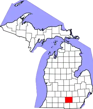 Map of Michigan | |
| Villages | ||
| Charter townships | ||
| Civil townships | ||
| CDPs | ||
| Other communities | ||
| Footnotes | ‡This populated place also has portions in an adjacent county or counties | |