Muş Province
Muş Province (Turkish: Muş ili; Armenian: Մուշի մարզ, romanized: Mushi marz; Kurdish: Parêzgeha Mûşê[2]) is a province in eastern Turkey. Its area is 8,718 km2,[3] and its population is 399,202 (2022),[1] down from 453,654 in 2000. The provincial capital is the city of Muş. Another town in Muş province, Malazgirt (Manzikert), is famous for the Battle of Manzikert of 1071.
Muş Province
Muş ili | |
|---|---|
 | |
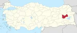 Location of the province within Turkey | |
| Country | Turkey |
| Seat | Muş |
| Government | |
| • Vali | Avni Çakır |
| Area | 8,718 km2 (3,366 sq mi) |
| Population (2022)[1] | 399,202 |
| • Density | 46/km2 (120/sq mi) |
| Time zone | TRT (UTC+3) |
| Area code | 0436 |
| Website | www |
History

The province is considered a part of historical Western Armenia.[4] Before the Armenian genocide, the area was a part of the Six Armenian Vilayets.[5][6] The province is considered part of Turkish Kurdistan and has a Kurdish majority.[7][8] Avni Çakır was appointed Governor of the province in August 2023.[9]
Geology and geomorphology
There are a total of 7 mountain ranges and 1 mountain, 4 of which are large, in the province of Muş. Muş province is surrounded by Otluk Mountains in the middle, Akdoğan Mountains and Mount Göztepe in the north, Bingöl Mountains in the northwest, Şerafettin Mountains in the west, Karaçavuş Mountains in the southwest, Yakupağa Mountains and Bilican Mountains in the southeast. [10]
Lakes
The main largest lakes in Muş are Lake Akdoğan, Lake Haçlı and Lake Kaz. [11]
Tourism
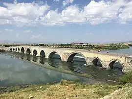
The touristic places in Muş are the historical Murat Bridge, the tulips on the Muş plain, Muş Castle, Haspet Castle, Mercimekkale Mound, Lake Akdoğan, Künav Cave, Lake Haçlı, and Kayalıdere Castle.[12]
Transportation
The city is served by the Muş Airport. It has a train station and a bus station.
Districts
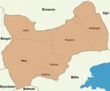
Muş province is divided into 6 districts (capital district in bold):
Economy
Historically, Muş was known for producing wheat.[13] The province also grew madder, but locals retained it, using it for dye.[14] The area also had salt mines. As of 1920, the region had so much salt that it was said to have enough to supply Europe and Asia.[15]
References
- "Address-based population registration system (ADNKS) results dated 31 December 2022, Favorite Reports" (XLS). TÜİK. Retrieved 19 September 2023.
- "Li Mûşê heta 15 rojan hemû çalakî hatin qedexekirin" (in Kurdish). Rûdaw. 4 November 2019. Retrieved 27 April 2020.
- "İl ve İlçe Yüz ölçümleri". General Directorate of Mapping. Retrieved 19 September 2023.
- Myhill, John (2006). Language, Religion and National Identity in Europe and the Middle East: A historical study. Amsterdam: J. Benjamins. p. 32. ISBN 978-90-272-9351-0.
- İsmail Soysal, Türkiye'nin Siyasal Andlaşmaları, I. Cilt (1920-1945), Türk Tarih Kurumu, 1983, p. 14.
- Verheij, Jelle (2012). Jongerden, Joost; Verheij, Jelle (eds.). Social Relations in Ottoman Diyarbekir, 1870–1915. Brill. p. 88. ISBN 978-90-04-22518-3
- Watts, Nicole F. (2010). Activists in Office: Kurdish Politics and Protest in Turkey (Studies in Modernity and National Identity). Seattle: University of Washington Press. p. 167. ISBN 978-0-295-99050-7.
- "Kurds, Kurdistān". Encyclopaedia of Islam (2 ed.). BRILL. 2002. ISBN 978-90-04-16121-4.
- "Valimiz". www.mus.gov.tr. Retrieved 25 October 2023.
- "Muş il fiziki haritası" (PDF) (in Turkish). Harita genel müdürlüğü. September 28, 2023. Archived (PDF) from the original on August 18, 2023.
- "Coğrafi Yapı". mus.gov.tr (in Turkish). Retrieved 2023-10-12.
- "Muş GoTürkiye". Muş İl Kültür ve Turizm Müdürlüğü (in Turkish). Retrieved 2023-10-06.
- Prothero, W.G. (1920). Armenia and Kurdistan. London: H.M. Stationery Office. p. 60.
- Prothero, W.G. (1920). Armenia and Kurdistan. London: H.M. Stationery Office. p. 62.
- Prothero, W.G. (1920). Armenia and Kurdistan. London: H.M. Stationery Office. p. 71.
External links
- Governor's web site.
- Muş Weather Forecast Information
- "Tarımın Kutlu Şehri Muş" (PDF) (in Turkish). DAKA Doğu Anadolu kalkınma ajansı.
