Musi River (Indonesia)
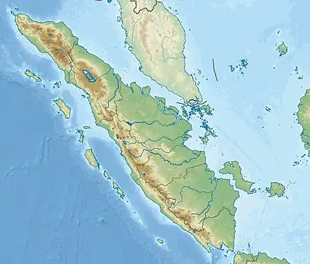
The Musi River (Indonesian: Sungai Musi) is a river in Southern Sumatra, Indonesia.[3] It flows from south-west to north-east, from the Barisan Mountains range that form the backbone of Sumatra, in Kepahiang Regency, Bengkulu Province, to the Bangka Strait that forms an extension of the South China Sea. It is about 750 kilometers long, and drains most of South Sumatra province. After flowing through Palembang, the provincial capital, it joins with several other rivers, including the Banyuasin River, to form a delta near the town of Sungsang. The river, dredged to a depth of about 6.5 meters, is navigable by large ships as far as Palembang, which is the site of major port facilities used primarily for the export of petroleum, rubber and palm oil.
| Musi River Sungai Musi, Air Musi, Musi River, Palembang River, Sungai Palembang, Air Moesi, Kali Musi | |
|---|---|
 Ampera Bridge over the Musi River | |
 Location of river mouth 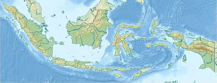 Musi River (Indonesia) (Indonesia) | |
| Location | |
| Country | South Sumatra, Indonesia |
| Physical characteristics | |
| Source | |
| • location | Barisan Mountains, Kepahiang, Bengkulu |
| Mouth | |
• location | Bangka Strait, South China Sea, South Sumatra |
| Length | 750 km (470 mi) |
| Basin size | 56,931 km2 (21,981 sq mi)[1] 59,942 km2 (23,144 sq mi) |
| Discharge | |
| • location | Musi Delta, Bangka Strait |
| • average | (Period of data: 1992-2016)3,054 m3/s (107,900 cu ft/s)[1] (Period of data: 2016-2020)3,066 m3/s (108,300 cu ft/s)[2] |
| • minimum | 1,400 m3/s (49,000 cu ft/s) |
| • maximum | 4,200 m3/s (150,000 cu ft/s) |
| Discharge | |
| • location | Palembang, (Confluence of Komering River - Basin size 53,500 km2 (20,700 sq mi) |
| • average | 2,700 m3/s (95,000 cu ft/s) |
| Basin features | |
| Average depth | 6.5 m (21 ft) |
This river system, especially around the city of Palembang, was the heart of eponymous 7th to 13th century Srivijayan empire. The river mouth was the site of the SilkAir Flight 185 plane crash which killed all 104 passengers and crew on board in 1997.
Geography
The river flows in the southern area of Sumatra with a predominantly tropical rainforest climate (designated as Af in the Köppen-Geiger climate classification).[4] The annual average temperature in the area is 24 °C. The warmest month is July, when the average temperature is around 26 °C, and the coldest is February, at 22 °C.[5] The average annual rainfall is 2579 mm. The wettest month is April, with an average of 344 mm rainfall, and the driest is September, with 99 mm rainfall.[6]
Gallery
 The Musi River and Palembang
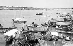 The Musi River by Palembang
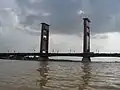 The Ampera Bridge on Musi River, Palembang
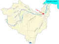 watershed of the Musi River
References
- Müller-Dum, Denise; Warneke, Thorsten; Rixen, Tim; Müller, Moritz; Baum, Antje; Christodoulou, Aliki; Oakes, Joanne; Eyre, Bradley D.; Notholt, Justus (2019). "Impact of peatlands on carbon dioxide (CO2) emissions from the Rajang River and Estuary, Malaysia". Biogeosciences. 16 (1): 17–32. Bibcode:2019BGeo...16...17M. doi:10.5194/bg-16-17-2019. S2CID 203167471.
- "Floating marine debris along Indonesian coasts" (PDF).
- Air Musi - Geonames.org.
- Peel, M C; Finlayson, B L; McMahon, T A (2007). "Updated world map of the Köppen-Geiger climate classification". Hydrology and Earth System Sciences. 11 (5): 1633–1644. Bibcode:2007HESS...11.1633P. doi:10.5194/hess-11-1633-2007. Retrieved 30 January 2016.
- "NASA Earth Observations Data Set Index". NASA. 30 January 2016.
- "NASA Earth Observations: Rainfall (1 month - TRMM)". NASA/Tropical Rainfall Monitoring Mission. 30 January 2016.
External links
 Media related to Musi River at Wikimedia Commons
- Banyuasin Musi River Delta conservation information from the ARCBC