Nærøysund
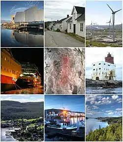
Nærøysund is a municipality in Trøndelag county, Norway. It is located in the traditional district of Namdalen. The municipality was established on 1 January 2020 after the merger of the old municipalities of Vikna and Nærøy. The municipality is unique in that it has two equal administrative centre: Kolvereid and Rørvik.[3] The other main population centres of Nærøysund include Abelvær, Foldereid, Gravvik, Ottersøy, Salsbruket, Steine, Torstad, Austafjord, Garstad, and Valøya.
Nærøysund kommune | |
|---|---|
 | |
 Trøndelag within Norway | |
 Nærøysund within Trøndelag | |
| Coordinates: 64.8393°N 11.4608°E | |
| Country | Norway |
| County | Trøndelag |
| District | Namdalen |
| Established | 1 Jan 2020 |
| • Preceded by | Vikna and Nærøy |
| Administrative centre | Kolvereid and Rørvik |
| Government | |
| • Mayor (2020) | Amund Hellesø (Ap) |
| Area | |
| • Total | 1,346.18 km2 (519.76 sq mi) |
| • Land | 1,286.33 km2 (496.65 sq mi) |
| • Water | 59.85 km2 (23.11 sq mi) 4.4% |
| • Rank | #70 in Norway |
| Population (2022) | |
| • Total | 9,732 |
| • Rank | #114 in Norway |
| • Density | 7.6/km2 (20/sq mi) |
| • Change (10 years) | |
| Demonyms | Nærøysunding Nærøysunder[1] |
| Official language | |
| • Norwegian form | Neutral |
| Time zone | UTC+01:00 (CET) |
| • Summer (DST) | UTC+02:00 (CEST) |
| ISO 3166 code | NO-5060 |
| Website | Official website |

The 1,346-square-kilometre (520 sq mi) municipality is the 70th largest by area out of the 356 municipalities in Norway. Nærøysund is the 114th most populous municipality in Norway with a population of 9,732. The municipality's population density is 7.6 inhabitants per square kilometre (20/sq mi) and its population has increased by 4.5% over the previous 10-year period.[4][5]
General information
Municipal history
The municipality was established on 1 January 2020 when the neighboring municipalities of Nærøy and Vikna were merged. The small Lund area of Nærøy was not part of the merger, it instead was merged with the large Namsos Municipality to the south on the same date. The merger came about because on 8 June 2017, the Norwegian Parliament, the Storting, voted to merge the municipalities of Leka, Vikna, Nærøy, and Bindal to form one, large municipality effective 1 January 2020.[6] Leka and Bindal municipalities rejected the merger, but Vikna and Nærøy agreed to the merger so it was carried out in 2020.[7]
Name
The municipality is named after the Nærøysundet strait which is located in the municipality. The strait is named after the nearby island Nærøya (Old Norse: Njarðøy). The first element is maybe the stem form of the name of the Norse god Njord (but it is suspicious that it is not in the genitive case). The last element is øy which means "island".[8][9]
Coat of arms
The coat of arms was approved for use starting on 1 January 2020. The blazon is "Argent, two bars wavy intertwined vert and azure". This means the arms have a field (background) that has a tincture of argent which means it is commonly colored white, but if it is made out of metal, then silver is used. The charge is two intertwined stripes, one green and one blue. The green symbolizes the land and agriculture while the blue symbolizes the sea and fishing industry. Both are intertwined like a rope to symbolize unity and the two old municipalities becoming one. The municipal flag has the same design as the coat of arms.[10][11][12]
Churches
The Church of Norway had two parishes (sokn) within the municipality of Nærøysund. It is part of the Namdal prosti (deanery) in the Diocese of Nidaros.
| Parish (sokn) | Church name | Location of the church | Year built |
|---|---|---|---|
| Nærøy | Foldereid Church | Foldereid | 1863 |
| Gravvik Church | Gravvik | 1875 | |
| Kolvereid Church | Kolvereid | 1874 | |
| Lundring Church | Lundring | 1885 | |
| Salsbruket Chapel | Salsbruket | 1950 | |
| Steine Chapel | Steine | 1911 | |
| Torstad Chapel | Torstad | 1936 | |
| Vikna | Garstad Church | Garstad | 1856 |
| Rørvik Church | Rørvik | 1896 | |
| Valøy Chapel | Valøya | 1972 |
Government
All municipalities in Norway, including Nærøysund, are responsible for primary education (through 10th grade), outpatient health services, senior citizen services, unemployment and other social services, zoning, economic development, and municipal roads. The municipality is governed by a municipal council of elected representatives, which in turn elects a mayor.[13] The municipality falls under the Namdal District Court and the Frostating Court of Appeal.
Municipal council
The municipal council (Kommunestyre) of Nærøysund is made up of 37 representatives that are elected to four year terms. The party breakdown of the council is as follows:
| Party Name (in Norwegian) | Number of representatives | |
|---|---|---|
| Labour Party (Arbeiderpartiet) | 14 | |
| Progress Party (Fremskrittspartiet) | 4 | |
| Green Party (Miljøpartiet De Grønne) | 1 | |
| Conservative Party (Høyre) | 5 | |
| Christian Democratic Party (Kristelig Folkeparti) | 1 | |
| Centre Party (Senterpartiet) | 9 | |
| Socialist Left Party (Sosialistisk Venstreparti) | 1 | |
| Liberal Party (Venstre) | 2 | |
| Total number of members: | 37 | |
Geography and climate

Nærøysund is named after the strait between the islands Inner-Vikna, Marøya, Nærøya and the mainland. This has been an important strait for sea travel along the coast at least since the Viking age. The western part of the municipality consist of an archipelago with almost 6,000 islands and islets going west into the Norwegian Sea, with many straits between the islands. There are three main islands, Inner-Vikna, Mellom-Vikna and Ytter-Vikna, which all three are connected to the mainland by bridges. The largest town Rørvik, with the main harbor, is situated on Inner-Vikna facing the mainland. The mainland part of the municipality is more rugged, with mountains up to 873 meter ASL, but also of some lowland areas around the town Kolvereid.
Coastal areas in Nærøysund has an oceanic climate (Cfb) as autumn and winter are the wettest seasons, even if the winter temperature is close to a humid continental climate. There are two official weather stations recording temperature in the municipality, one at Rørvik Airport at Inner-Vikna island, the other at Nordøyan lighthouse further southwest on a smaller island. Nordøyan is warmer in winter with coldest monthly mean 1.4 °C (34.5 °F), but is cooler in summer compared to Rørvik. The all-time low at Rørvik Airport was recorded in January 2010, and the all-time high 32.9 °C (91.2 °F) was recorded July 27, 2019.
| Climate data for Rørvik Airport 1991-2020 (4 m, precipitation Rørvik-Engan, extremes 2002-2023) | |||||||||||||
|---|---|---|---|---|---|---|---|---|---|---|---|---|---|
| Month | Jan | Feb | Mar | Apr | May | Jun | Jul | Aug | Sep | Oct | Nov | Dec | Year |
| Record high °C (°F) | 9.4 (48.9) |
9 (48) |
12.9 (55.2) |
20.9 (69.6) |
26.5 (79.7) |
30.5 (86.9) |
32.9 (91.2) |
29.3 (84.7) |
23.8 (74.8) |
18.9 (66.0) |
13.8 (56.8) |
9.6 (49.3) |
32.9 (91.2) |
| Average high °C (°F) | 2 (36) |
2 (36) |
4 (39) |
7 (45) |
11 (52) |
14 (57) |
17 (63) |
17 (63) |
14 (57) |
9 (48) |
5 (41) |
2 (36) |
9 (48) |
| Daily mean °C (°F) | 0.7 (33.3) |
−0.1 (31.8) |
1.2 (34.2) |
4.5 (40.1) |
7.8 (46.0) |
10.8 (51.4) |
14 (57) |
13.7 (56.7) |
10.8 (51.4) |
6.1 (43.0) |
3.4 (38.1) |
1.4 (34.5) |
6.2 (43.1) |
| Average low °C (°F) | −1 (30) |
−2 (28) |
−1 (30) |
2 (36) |
7 (45) |
10 (50) |
13 (55) |
11 (52) |
9 (48) |
5 (41) |
2 (36) |
0 (32) |
5 (40) |
| Record low °C (°F) | −19.2 (−2.6) |
−18 (0) |
−16.9 (1.6) |
−8.3 (17.1) |
−4.9 (23.2) |
−1 (30) |
1.9 (35.4) |
0 (32) |
−3.3 (26.1) |
−9.8 (14.4) |
−14.5 (5.9) |
−16.7 (1.9) |
−19.2 (−2.6) |
| Average precipitation mm (inches) | 138 (5.4) |
130 (5.1) |
115 (4.5) |
78 (3.1) |
81 (3.2) |
101 (4.0) |
87 (3.4) |
98 (3.9) |
145 (5.7) |
136 (5.4) |
140 (5.5) |
160 (6.3) |
1,409 (55.5) |
| Source 1: Norwegian Meteorological Institute[15] | |||||||||||||
| Source 2: Tititudorancea (avg highs/lows) [16] | |||||||||||||
Notable people
_(7859244812).jpg.webp)

- Jens Schanche (1717 in Ytter-Vikna – 1787) a Norwegian postmaster and postal inspector
- Georg Sverdrup (1770 in Laugen – 1850) a statesman, a president of the Norwegian Constituent Assembly in Eidsvoll
- Jacob Liv Borch Sverdrup (1775 in Laugen – 1841) a Norwegian educator and farmer
- James M. Wahl (1846 at Storvahl - 1939) a pioneer Norwegian American settler in South Dakota
- Axel Collett (1880 in Kolvereid – 1968) a landowner, timber merchant and sawmill owner
- Magnhild Haalke (1885 in Vikna – 1984) a Norwegian novelist
- Ivar Skjånes (1888 in Kolvereid – 1975) politician, Mayor of Trondheim and County Governor of Sør-Trøndelag
- Birger Brandtzæg (1893 in Abelvær – 1971) a merchant and owner of a fishing station
- Brita Collett Paus (1917 in Salsbruket – 1998) a humanitarian and the founder of Fransiskushjelpen
- Paal Bog (born 1919 in Nærøy - 2002) an economist, civil servant, diplomat and Chairman of UNICEF
- Gullow Gjeseth (1937 in Nærøy – 2017) a military officer, commander of the land-based military forces
- Børre Rønningen (born 1949 in Vikna) a Norwegian politician, Mayor of Vikna 1999-2003
- Lars Peder Brekk (born 1955 in Vikna) a Norwegian businessman and politician
- Hilde Stavik (1962 in Kolvereid – 2015) a Norwegian long-distance runner
References
- "Navn på steder og personer: Innbyggjarnamn" (in Norwegian). Språkrådet.
- "Forskrift om målvedtak i kommunar og fylkeskommunar" (in Norwegian). Lovdata.no.
- Rosvold, Knut A., ed. (20 January 2020). "Nærøysund". Store norske leksikon (in Norwegian). Kunnskapsforlaget. Retrieved 10 April 2020.
- Statistisk sentralbyrå (2020). "Table: 06913: Population 1 January and population changes during the calendar year (M)" (in Norwegian).
- Statistisk sentralbyrå (2020). "09280: Area of land and fresh water (km²) (M)" (in Norwegian).
- "Kommunesammenslåing Nærøy, Vikna, Leka, og Bindal" (PDF) (in Norwegian). Leka kommune. 21 August 2017. Retrieved 26 September 2017.
- "Navn på ny kommune" (in Norwegian). Vikna kommune. 5 February 2018. Archived from the original on 30 April 2018. Retrieved 29 April 2018.
- Store norske leksikon. "Nærøy – Nord-Trøndelag" (in Norwegian). Retrieved 3 October 2011.
- Rygh, Oluf (1903). Norske gaardnavne: Nordre Trondhjems amt (in Norwegian) (15 ed.). Kristiania, Norge: W. C. Fabritius & sønners bogtrikkeri. p. 354.
- "Slik blir Nærøysunds kommunevåpen". Namdals Avisa (in Norwegian). Retrieved 30 December 2019.
- "Dette er de to forslagene til kommunevåpen som politikerne i Nærøy og Vikna får forelagt" (in Norwegian). Ytringen.no. Retrieved 30 December 2019.
- "Nærøysund kommune, våpen". Digitalarkivet (in Norwegian). Arkivverket. Retrieved 15 February 2023.
- Hansen, Tore, ed. (12 May 2016). "kommunestyre". Store norske leksikon (in Norwegian). Kunnskapsforlaget. Retrieved 20 October 2019.
- "Tall for Norge: Kommunestyrevalg 2019 - Trøndelag". Valg Direktoratet. Retrieved 19 October 2019.
- "Norwegian Meteorological Institute".
- "Climate Rørvik-Ryum Norway". Tititudorancea. Retrieved 3 June 2023.
| |||
 | Towns and cities |  | |
| Municipalities | |||