Na Krasaeng
Na Krasaeng (Thai: นากระแซง) is a tambon (subdistrict) of Det Udom District, in Ubon Ratchathani Province, Thailand.[1][2][3][4] In 2021, it had a population of 13,602 people.[1] Neighbouring subdistricts are (clockwise from the south) Nong Om, Thung Thoeng, Khok Sawang, Na Charoen, and Som Sa-at.[2]
Na Krasaeng
นากระแซง | |
|---|---|
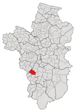 Subdistrict location in Ubon Ratchathani province | |
| Country | Thailand |
| Province | Ubon Ratchathani |
| District | Det Udom |
| Mubans | 13 |
| Number of Mu | 16 |
| Subdistrict established | 1983 |
| Area | |
| • Total | 96.60 km2 (37.30 sq mi) |
| Population (2021) | |
| • Total | 13,602 |
| • Density | 140.81/km2 (364.7/sq mi) |
| Time zone | UTC+7 (ICT) |
| Postal code | 34160 |
History
The region was first settled in 1934 by five household villagers who evacuated from Khum village (บ้านคุ้ม) in Warin Chamrap district; a new village was unofficially called "Nong Khee Kwai" (หนองขี้ควาย; Cow dung pond's village), after the feature of the pond nearby.[3] Later in 1945, the community size increased to 60–70 households, and the district government of Det Udom then renamed it "Na Krasaeng," after the runnel name formed in the area, as well as officially registering it as a new village under the control of Som Sa-at subdistrict.[3] After that, the village was transferred to be a member of the Thung Thoeng subdistrict, then to Nong Om and Na Charoen, until it obtained subdistrict status in 1983.[3][4]
Geography
The tambon is located in the southwestern region of the Det Udom district, on a plateau with a tropical savanna climate.[2]
Administration
The tambon is divided into 13 administrative villages (mubans; หมู่บ้าน), one of which, Na Krasaeng village, was further divided into four community groups (Mu; หมู่).[1][2] The entire area is governed by the Subdistrict Administrative Organization of Na Krasaeng (องค์การบริหารส่วนตำบลนากระแซง; Na Krasaeng SAO).[1][2]
The following is a list of the subdistrict's mubans, which roughly correspond to the villages, as of the 2021 census.[1]
| Village | Group (Mu) | Household | Population | |
|---|---|---|---|---|
| Romanized name | Thai name | |||
| Na Krasaeng | นากระแซง | 1 | 327 | 879 |
2 | 323 | 888 | ||
13 | 280 | 843 | ||
16 | 138 | 455 | ||
| Thai Wattana | ไทยวัฒนา | 3 | 490 | 1,218 |
| Non Sawang | โนนสว่าง | 4 | 266 | 829 |
| Nong Tae | หนองแต้ | 5 | 406 | 1,143 |
| Mo Thong | หม้อทอง | 6 | 381 | 1,017 |
| Nong Ngern Hoy | หนองเงินฮ้อย | 7 | 540 | 1,421 |
| Toei | เตย | 8 | 390 | 1093 |
| Don Klang | ดอนกลาง | 9 | 383 | 1,374 |
| Nong Hai | หนองไฮ | 10 | 292 | 934 |
| Udom Pattana | อุดมพัฒนา | 11 | 229 | 472 |
| Kham Prasert | คำประเสริฐ | 12 | 91 | 404 |
| Rai Srisuk | ไร่ศรีสุข | 14 | 169 | 448 |
| Pa Teaw | ป่าติ้ว | 15 | 98 | 284 |
| Grand total | 4,803 | 13,602 | ||
References
- "โครงสร้างข้อมูลสถิติจำนวนประชากร" (in Thai). Department of Provincial Administration of Thailand. 2021. Archived from the original on 14 December 2022. Retrieved 15 December 2022. Alt URL
- "สภาพทั่วไป". Nakrazang.go.th (in Thai). Subdistrict Administrative Organization of Na Krasaeng. Archived from the original on 21 June 2022. Retrieved 16 December 2022.
- "ประวัติความเป็นมา". Nakrazang.go.th (in Thai). Subdistrict Administrative Organization of Na Krasaeng. Archived from the original on 19 June 2022. Retrieved 16 December 2022.
- "ประกาศกระทรวงมหาดไทย เรื่อง ตั้งและเปลี่ยนแปลงเขตตำบลในท้องที่อำเภอเดชอุดม อำเภอกุดข้าวปุ้น จังหวัดอุบลราชธานี" (PDF). www.ratchakitcha.soc.go.th (in Thai). Royal Thai Government Gazette. 9 August 1983. Archived from the original (PDF) on 1 August 2019. Retrieved 15 December 2022.