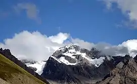
Om Parvat
Om Parvat a mountain located in Darchula district, Byash, Nepal[2][3] Om Parvat peak elevation is 5,590 m (18,340 ft) above sea level.[4] It is reached by the paved motorable Pithoragagh-Lipulekh Pass Highway (PLPH) NH-9 along Kali River (Sharda River), via a spur along glaciated rivulet to Om Parvat from Nabhidhang. Route to Adi Kailash, from the forks at Gunji, goes northwest via Kuthi Valley along the Kuthi Yankti river. Mount Kailash in Tibet can be viewed from India from the Old Lipulekh Pass which lies northeast of Gunji (via NH-9 motorable till the pass) and the Limpiyadhura Pass (via Kuthi Valley) which lies northwest of Gunji.
| Om Parvat | |
|---|---|
 Om Parvat Mountain, 22 December 2021 | |
| Highest point | |
| Elevation | 5,590 m (18,340 ft)[1] |
| Coordinates | 30°11′48″N 81°01′57″E |
| Geography | |
| Location | Byash, Darchula District, Nepal |
| Parent range | Himalayas |
The Om Parvat and the Adi Kailash and are not one and the same,[5] although there may be confusion in some sources. NH-9 extension from Pithoragarh goes to Gunji (Dame La). Gunji is the confluence of NW-S flowing Kuthi Yankti river and NE-S flowing Kali River. Kuthi Yankti river arises from the Limpiyadhura Pass northwest of Gunji and flows through Kuthi Valley to Gunji in south. The Kali River arises from the Lipulekh Pass northeast of Gunji and flows by the KMVN Huts (Kumaon Mandal Vikas Nigam resort) at Nabhidhang (a fork route from Nabhidhang goes southeast along the glaciated rivulet to Om Parvat), Nepal Armycamp, Nepal Police Checkpost to Gunji.
Sacred Status
It is considered sacred by Hindus and its snow deposition pattern resembles the sacred 'Om' (ॐ). Near Om Parvat, Parvat Lake and "Jonglingkong Lake". Jonglingkong Lake is sacred, as Lake Manasarovar, to the Hindus.
Om Parvat yatra circuit
Om Parvat can be viewed on the route to the Kailash Manasarovar Yatra from the last camp (Nabhidhang Pass west of KMVN Huts) enroute Lipulekh Pass. Recently it is also claimed by Nepal, that the territory falls under Darchula District, Nepal, Where India claim it in Indian Uttarakhand side on Dharchula, Pithoragarh district. But it has always been the sacred mountain for Hindus among all over the world.[6] Many trekkers to Adi Kailash in Kuthi Valley often make a diversion at Gunji to view Om Parvat. Om Parvat is located east of Nabhi Dhang camp on Mount Kailash-Lake Manasarovar yatra route. Mount Kailash could be viewed from the Limpiyadhura Pass as well as the Old Lipulekh Pass (couple of kilometer west of Lipulekh Pass).
Adi Kailash Yatra Circuit
The Adi Kailash or Shiva Kailash is located in a different direction from the Om Parvat. Adi Kailash is located near Sin La pass and near Brahma Parvat. The base camp of Adi Kailash is 17 km from the Kuthi (Kuti) village in Kuthi Valley at sacred Jolingkong Lake which has a Hindu Shiva temple on its bank.[7]
The Adi Kailash Yatra Circuit begins by going up the Darma Valley and then going to Kuthi Yankti Valley via the Sin La pass to join the Mount Kailash-Lake Manasarovar Tibetan pilgrimage route down the Sharda River.[7]
See also
References
- "Nepal Nordwest". Gurans Himal (in German). Retrieved 16 October 2021.
- "Om Parvat". PeakVisor. Retrieved 27 June 2022.
- "Om Parvat India - Nepal Border Himalayan Range | Om Peak Dharchula info". www.euttaranchal.com. Retrieved 6 March 2023.
- "Om Parvat". PeakVisor. Retrieved 4 January 2022.
- "Om Parvat". Peakware.com. Archived from the original on 4 March 2016. Retrieved 20 April 2019.
- Arpi, Claude (28 October 2015). "EDITORIAL: Borderline blues". Asia News Network. Archived from the original on 4 February 2017. Retrieved 16 October 2021.
- "Little Kailash expedition Sept 19th-Oct 14th 2002". Wayback Machine. Archived from the original on 26 March 2008. Retrieved 17 October 2021.