Al-Hasakah Subdistrict
Al-Hasakah Subdistrict (Arabic: ناحية مركز الحسكة) is a subdistrict of al-Hasakah District in central al-Hasakah Governorate, northeastern Syria. The administrative centre is the city of al-Hasakah. It has a mixed population of Kurds, Assyrians, and Arabs. Most of the subdistrict is part of the Autonomous Administration of North and East Syria, apart from an enclave of Hasakah city, which has remained under the control of the Syrian government since the beginning of the Syrian civil war.
Al-Hasakah Subdistrict
ناحية مركز الحسكة | |
|---|---|
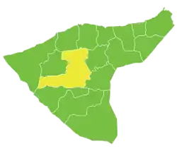 Location of Al-Hasakah Subdistrict within al-Hasakah Governorate | |
| Country | |
| Governorate | al-Hasakah |
| District | Al-Hasakah District, Al-Hasakah Governorate |
| Seat | al-Hasakah |
| Area | |
| • Total | 2,509.56 km2 (968.95 sq mi) |
| Population (2004)[1] | 251,570 |
| Geocode | SY080000 |
At the 2004 census, the subdistrict had a population of 251,570.[1]
Cities, towns and villages
| PCode | Name | Population |
|---|---|---|
| C4360 | al-Hasakah | 188,160 |
| C4351 | al-Tweinah | 5,062 |
| — | Western Tell Tawil | 3,109 |
| C4354 | Safya | 2,849 |
| C4378 | Qaber Amer | 2,205 |
| C4343 | Tal Majdal | 2,153 |
| C4365 | Eastern Hamra | 2,088 |
| C4361 | Eastern Rajman | 1,950 |
| C4347 | Western Sabe Skur | 1,860 |
| — | — | 1,676 |
| — | — | 1,597 |
| C4366 | Um Elmilh | 1,566 |
| — | — | 1,443 |
| C4340 | Kherbet Elias | 1,348 |
| C4349 | Salaliyeh | 1,298 |
| — | — | 1,204 |
| C4334 | Um Qasir Almjarjaa | 1,153 |
| C4369 | Sayed Ali | 1,130 |
| C4346 | Rafraf | 1,022 |
| C4371 | Tal Baydar Haskeh | 958 |
| — | Karama | 936 |
| — | — | 910 |
| — | — | 860 |
| — | — | 826 |
| C4367 | Ein Elhara | 790 |
| C4374 | Rehiyeh Nameh | 774 |
| C4368 | Sulaymaniya | 753 |
| — | — | 731 |
| — | — | 725 |
| C4364 | Um Elmaez | 715 |
| — | — | 688 |
| — | — | 683 |
| C4344 | Um Elshok | 642 |
| — | — | 642 |
| C4376 | Qubbet Elsokhur | 594 |
| — | — | 571 |
| C4373 | Zaydiyeh Hasskeh | 563 |
| C4380 | Msheirfet Elashmal | 518 |
| C4381 | Mahd Elrijleh | 511 |
| C4357 | Masudiyeh Haska | 480 |
| C4348 | Duwadiyeh Haskeh | 478 |
| C4370 | Southern Lower Um Hajra | 465 |
| C4355 | Um Eldibis Elhiskeh | 462 |
| — | Noman | 445 |
| C4341 | Abu Rasin Haskeh | 426 |
| C4350 | Hafayer | 405 |
| — | — | 373 |
| C4362 | Matl | 364 |
| — | — | 359 |
| C4336 | Razaza | 352 |
| — | — | 341 |
| — | — | 327 |
| C4331 | Khazneh | 313 |
| — | — | 311 |
| C4359 | Eastern Taban | 308 |
| C4377 | Nurak | 308 |
| C4363 | First Mabtuh | 306 |
| — | — | 253 |
| — | — | 249 |
| — | — | 244 |
| C4382 | Masudiyeh Elbizara | 227 |
| C4358 | Tal Mansur Haskeh | 218 |
| — | — | 214 |
| — | — | 207 |
| — | — | 206 |
| — | — | 204 |
| — | — | 201 |
| — | — | 199 |
| C4383 | Western Qamar | 198 |
| — | — | 198 |
| — | — | 186 |
| C4337 | Madina | 181 |
| C4372 | Tal Shaalan | 181 |
| — | — | 180 |
| C4332 | Um Hajra Almoqbela | 173 |
| — | — | 173 |
| — | — | 166 |
| — | — | 163 |
| — | — | 159 |
| — | — | 157 |
| — | — | 152 |
| C4339 | Sofya | 150 |
| — | — | 150 |
| C4338 | Shama | 149 |
| — | — | 149 |
| C4356 | Lower Tal Aswad | 148 |
| — | — | 145 |
| — | — | 141 |
| — | — | 140 |
| — | — | 135 |
| — | — | 132 |
| C4379 | Qaber Elkhalif | 126 |
| — | — | 125 |
| C4335 | Jdideh | 124 |
| C4342 | Talaah | 121 |
| — | — | 121 |
| C4353 | Harmala | 115 |
| C4352 | Upper Tal Aswad | 106 |
| — | — | 105 |
| — | — | 86 |
| — | — | 82 |
| C4375 | Hilaliyeh | 65 |
| C4333 | Rahmaniya | 62 |
| — | Kherbet Elfaras | 49 |
| — | — | 34 |
| — | — | 23 |
| — | — | 9 |
| — | — | 3 |
| Umm al Quşayr |
Civil war
Following the Battle of Shaddadi in February 2013, in which the city of Al-Shaddadah came under the control of al-Nusra Front, the southern parts of Al-Hasakah Subdistrict also fell to Nusra. The Islamic State of Iraq and the Levant (ISIL) took over from al-Nusra Front in the area, and pushed northwards up to the boundary of Hasakah city, culminating in the 2015 Battle of al-Hasakah.[2] ISIL were finally driven from the district in the Al-Shaddadi offensive (2016).
Kawkab military base
Surrounding Mount Kawkab (Arabic: تلة كوكب, at 36.536251°N, 40.858276°E) is the largest military base of the governorate, which has remained in the hands of the Syrian Army throughout the war.[3] ISIS attacked the base without success in July 2014 and October 2015.[4][5]
References
- "2004 Census Data for Nahiya al-Hasakah" (in Arabic). Syrian Central Bureau of Statistics. Archived from the original on 10 October 2017. Retrieved 15 October 2015. Also available in English: "2004 Census Data". UN OCHA. Retrieved 15 October 2015.
- "176 killed as ISIS advance in northeast Syria". TRT World. 5 June 2015. Archived from the original on 11 July 2015. Retrieved 20 July 2015.
- "للمرة الثانية تنظيم الدولة يقطع الطريق بين الشدادي والحسكة (The road between Shaddadi and Hasaka cut again)". Baladi News (in Arabic). 15 December 2015. Retrieved 21 January 2017.
- Cafarella, Jennifer (9 August 2014). "ISIS Works to Merge its Northern Front across Iraq and Syria". Institute for the Study of War. Retrieved 21 January 2017.
- Shiwesh, Ahmed (18 October 2015). "Syrian troops in Hasakah defend army base against ISIS attacks". ARA News. Archived from the original on October 20, 2015. Retrieved 21 January 2017.