Narowlya District
Narowlya District (Belarusian: Нараўлянскі раён, romanized: Naraulianski rajon; Russian: Наровлянский район) is a district (raion) of Gomel Region in Belarus. Its administrative center is the town of Narowlya.
Narowlya District
| |
|---|---|
 Flag  Coat of arms | |
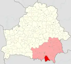 Location of Narowlya District within Gomel Region in Belarus | |
| Coordinates: 51°48′N 29°30′E | |
| Country | Belarus |
| Region | Gomel Region |
| Administrative center | Narowlya |
| Area | |
| • Total | 1,588.82 km2 (613.45 sq mi) |
| Population (2023)[1] | |
| • Total | 10,494 |
| • Density | 6.6/km2 (17/sq mi) |
| Time zone | UTC+3 (MSK) |
| Website | Official website |
Geography
The district includes the town of Narowlya, six rural councils (selsoviets), and several villages. Following the 1986 Chernobyl disaster, it is partially included in the Polesie State Radioecological Reserve.[2][3]
See also
References
- "Численность населения на 1 января 2023 г. и среднегодовая численность населения за 2022 год по Республике Беларусь в разрезе областей, районов, городов, поселков городского типа". belsat.gov.by. Archived from the original on 17 April 2023. Retrieved 5 August 2023.
- Polesie Radio-ecological Zapovednik Archived 2016-07-31 at the Wayback Machine (APB BirdLife Belarus)
- 253459229 Polesie State Radioecological Reserve on OpenStreetMap
This article is issued from Wikipedia. The text is licensed under Creative Commons - Attribution - Sharealike. Additional terms may apply for the media files.