Natashquan
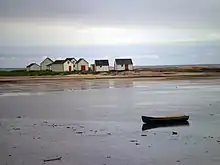
Natashquan is a municipality in Minganie Regional County Municipality, Côte-Nord region, Quebec, Canada. It should not be confused with the adjacent but separate Innu reserve of Nutashkuan.
Natashquan | |
|---|---|
Municipality | |
 | |
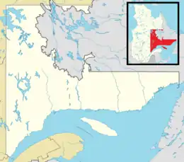
 Natashquan Location in Côte-Nord region of Quebec | |
| Coordinates: 50°11′N 61°49′W[1] | |
| Country | Canada |
| Province | Quebec |
| Region | Côte-Nord |
| RCM | Minganie |
| Settled | 1855 |
| Constituted | September 16, 1907 |
| Government | |
| • Mayor | Jacques Landry |
| • Federal riding | Manicouagan |
| • Prov. riding | Duplessis |
| Area | |
| • Total | 69,543 km2 (26,851 sq mi) |
| • Land | 667.91 km2 (257.88 sq mi) |
| Elevation | 10.7 m (35.1 ft) |
| Population (2021)[3] | |
| • Total | 262 |
| • Density | 0.4/km2 (1/sq mi) |
| • Pop 2016–2021 | |
| • Dwellings | 156 |
| Time zone | UTC−05:00 (Within the AST legislated time zone boundary but observes EST[4]) |
| • Summer (DST) | UTC−04:00 (EDT) |
| Postal code(s) | |
| Area code(s) | 418 and 581 |
| Highways | |
| Website | www |
The municipality is named after the Natashquan River, which had already been mapped and named in the 17th century. It comes from the Innu language, meaning "where one hunts for bear".[1]
In addition to the village of Natashquan itself, the municipality also includes the small community of Pointe-Parent (50°07′49″N 61°48′02″W) that is located on the Natashquan River, directly adjacent to the Natashquan Reserve. It is home to some fishermen's homes and was served by a post office from 1953 to 1976. Once also known as Pointe-du-Poste and Village-du-Poste, Pointe-Parent was named after priest Pierre-Clément Parent (1733–1784) who served as missionary in Tadoussac and Labrador and died in Natashquan.[5]
History

While Jacques Cartier had visited the area in 1534 and a trading post already existed in 1710 at the mouth of the Natashquan River, the settlement of Natashquan in the eponymous township was not founded until 1855 when the first settlers arrived. They were Acadians from the Magdalen Islands, particularly from Amherst Island (île du Havre Aubert). That same year, the Notre-Dame-de-Natashquan Mission was founded on the west bank of the Little Natashquan River. In 1869, the township was officially established, and in August 1872, the post office opened. In 1907, the place was incorporated as a township municipality. For many decades Natashquan was dependent on fishing, but nowadays few fishermen remain.[1][6]
In 1958, the first electricity cooperative was formed and electricity was finally installed in homes. Television followed in the 1970s.[7]
Before 1996, it was only accessible via boat or airplane. That year, Route 138 was extended to Natashquan, connecting it to Havre-Saint-Pierre and ending its isolation from Quebec's road network.[7]
On June 18, 2016, Natashquan changed status from township municipality to a (regular) municipality.[8]
Geography
The community is located on the north shore of the Jacques Cartier Strait and the Gulf of Saint Lawrence, straddling both banks of the Little Natashquan River, some 120 km (75 mi) east of Havre-Saint-Pierre. The township is bordered on the east and south by the estuary of the Natashquan River, and encompasses an area that is riddled with numerous small ponds and lakes.[9]
Climate
Natashquan experiences a borderline subarctic climate (Köppen Dfc) that is just short of being classed as a humid continental climate (Köppen Dfb). Summers are mild, moderated by the Gulf of St Lawrence and winters are cold and snowy, with annual snowfall averaging 140 inches (356 cm).[10]
| Climate data for Natashquan (1991–2020 normals, extremes 1914–present) | |||||||||||||
|---|---|---|---|---|---|---|---|---|---|---|---|---|---|
| Month | Jan | Feb | Mar | Apr | May | Jun | Jul | Aug | Sep | Oct | Nov | Dec | Year |
| Record high °C (°F) | 8.2 (46.8) |
6.7 (44.1) |
12.8 (55.0) |
17.8 (64.0) |
23.9 (75.0) |
26.4 (79.5) |
29.3 (84.7) |
28.3 (82.9) |
26.1 (79.0) |
19.4 (66.9) |
14.4 (57.9) |
9.4 (48.9) |
29.3 (84.7) |
| Average high °C (°F) | −8.0 (17.6) |
−7.2 (19.0) |
−2.2 (28.0) |
3.4 (38.1) |
9.7 (49.5) |
15.0 (59.0) |
18.5 (65.3) |
18.2 (64.8) |
14.2 (57.6) |
8.1 (46.6) |
1.9 (35.4) |
−4.3 (24.3) |
5.6 (42.1) |
| Daily mean °C (°F) | −13.5 (7.7) |
−12.7 (9.1) |
−7.1 (19.2) |
−0.3 (31.5) |
5.5 (41.9) |
10.7 (51.3) |
14.4 (57.9) |
14.1 (57.4) |
10.0 (50.0) |
4.2 (39.6) |
−1.9 (28.6) |
−9.0 (15.8) |
1.2 (34.2) |
| Average low °C (°F) | −19.0 (−2.2) |
−18.1 (−0.6) |
−12.0 (10.4) |
−3.9 (25.0) |
1.3 (34.3) |
6.3 (43.3) |
10.3 (50.5) |
9.9 (49.8) |
5.7 (42.3) |
0.3 (32.5) |
−5.6 (21.9) |
−13.7 (7.3) |
−3.2 (26.2) |
| Record low °C (°F) | −42.8 (−45.0) |
−37.2 (−35.0) |
−33.7 (−28.7) |
−22.5 (−8.5) |
−12.8 (9.0) |
−3.9 (25.0) |
1.1 (34.0) |
−1.1 (30.0) |
−7.8 (18.0) |
−15.0 (5.0) |
−25.6 (−14.1) |
−35.0 (−31.0) |
−42.8 (−45.0) |
| Average precipitation mm (inches) | 91.4 (3.60) |
69.6 (2.74) |
90.4 (3.56) |
80.3 (3.16) |
86.1 (3.39) |
88.0 (3.46) |
105.4 (4.15) |
92.2 (3.63) |
95.0 (3.74) |
103.6 (4.08) |
103.4 (4.07) |
93.9 (3.70) |
1,099.3 (43.28) |
| Average rainfall mm (inches) | 17.6 (0.69) |
13.4 (0.53) |
26.7 (1.05) |
50.9 (2.00) |
82.1 (3.23) |
88.0 (3.46) |
105.4 (4.15) |
93.7 (3.69) |
95.0 (3.74) |
98.8 (3.89) |
69.3 (2.73) |
25.8 (1.02) |
766.7 (30.18) |
| Average snowfall cm (inches) | 79.5 (31.3) |
61.2 (24.1) |
67.7 (26.7) |
30.8 (12.1) |
4.1 (1.6) |
0.0 (0.0) |
0.0 (0.0) |
0.0 (0.0) |
0.0 (0.0) |
5.0 (2.0) |
34.9 (13.7) |
72.3 (28.5) |
355.5 (140) |
| Average precipitation days (≥ 0.2 mm) | 19.1 | 16.7 | 16.1 | 14.3 | 14.1 | 12.8 | 15.0 | 12.8 | 13.7 | 15.1 | 15.4 | 17.7 | 182.8 |
| Average rainy days (≥ 0.2 mm) | 1.9 | 2.4 | 4.4 | 8.8 | 13.5 | 12.8 | 15.0 | 12.8 | 13.7 | 14.5 | 9.3 | 4.3 | 113.4 |
| Average snowy days (≥ 0.2 cm) | 18.7 | 15.7 | 14.0 | 8.8 | 1.5 | 0.0 | 0.0 | 0.0 | 0.0 | 2.0 | 9.2 | 16.1 | 86.0 |
| Mean monthly sunshine hours | 103.3 | 120.9 | 146.6 | 165.3 | 205.6 | 224.0 | 235.3 | 227.8 | 171.4 | 126.0 | 96.4 | 87.2 | 1,909.8 |
| Source: Environment Canada[11] | |||||||||||||
Demographics
| 2021 | 2016 | 2011 | |
|---|---|---|---|
| Population | 262 (-0.4% from 2016) | 263 (-5.1% from 2011) | 246 (-6.8% from 2006) |
| Land area | 667.91 km2 (257.88 sq mi) | 197.60 km2 (76.29 sq mi) | 203.51 km2 (78.58 sq mi) |
| Population density | 0.4/km2 (1.0/sq mi) | 1.3/km2 (3.4/sq mi) | 1.2/km2 (3.1/sq mi) |
| Median age | 52.4 (M: 55.6, F: 48.4) | 53.5 (M: 54.8, F: 52.0) | 52.5 (M: 52.8, F: 51.8) |
| Private dwellings | 125 (total) | 158 (total) | 165 (total) |
| Median household income | $63,360 | $.N/A |
|
| ||||||||||||||||||||||||||||||||||||
| Source: Statistics Canada | |||||||||||||||||||||||||||||||||||||
Language
Mother tongue:
- English as first language: 0%
- French as first language: 96.2%
- English and French as first language: 0%
- Other as first language: 3.8%
Transport
The main road through Natashquan is Quebec Route 138, and it is also served by Natashquan Airport and Natashquan (Lac de l'Avion) Water Aerodrome.
Notable people
Natashquan was the birthplace of singer Gilles Vigneault, who named a song after the municipality ("C'est à Natashquan") on the 2008 album Arriver Chez Soi.
References
- "Reference number 43497 in Banque de noms de lieux du Québec". toponymie.gouv.qc.ca (in French). Commission de toponymie du Québec.
- "Répertoire des municipalités - Natashquan". www.mamh.gouv.qc.ca (in French). Ministère des Affaires municipales et de l'Habitation. Retrieved 5 May 2022.
- "Natashquan, Municipalité (MÉ) Quebec Census Profile, 2021 Census of Population". www12.statcan.gc.ca. Government of Canada - Statistics Canada. 9 February 2022. Retrieved 5 May 2022.
- National Research Council Canada – Time Zones & Daylight Saving Time Archived 2010-03-17 at the Wayback Machine
- "Pointe-Parent (hameau)" (in French). Commission de toponymie du Québec. Retrieved 2010-09-16.
- "Natashquan (Bureau de poste)" (in French). Commission de toponymie du Québec. Retrieved 2010-09-14.
- "Historique de Natashquan". www.natashquan.org. Municipalité de Natashquan. Retrieved 5 May 2022.
- "Modifications aux municipalités du Québec" (PDF). Modifications Aux Municipalités du Québec. Institut de la statistique du Québec. June 2016. ISSN 1715-6408.
- "Natashquan (Canton)" (in French). Commission de toponymie du Québec. Retrieved 2010-09-14.
- Canada, Environment and Climate Change (2013-09-25). "Canadian Climate Normals 1981–2010 Station Data - Climate - Environment and Climate Change Canada". climate.weather.gc.ca. Retrieved 2020-06-08.
- "Temperature and Precipitation Graph for 1981 to 2010 Canadian Climate Normals NATASHQUAN A". Environment Canada. Government of Canada. 25 September 2013. Retrieved April 16, 2019.
- "2021 Community Profiles". 2021 Canadian Census. Statistics Canada. February 4, 2022. Retrieved 2022-04-27.
- "2016 Community Profiles". 2016 Canadian Census. Statistics Canada. August 12, 2021. Retrieved 2022-05-05.
- "2011 Community Profiles". 2011 Canadian Census. Statistics Canada. March 21, 2019. Retrieved 2014-02-16.
- "2006 Community Profiles". 2006 Canadian Census. Statistics Canada. August 20, 2019.
- "2001 Community Profiles". 2001 Canadian Census. Statistics Canada. July 18, 2021.
- "Toporama – Topographic Map Sheet 12K4". Atlas of Canada. Natural Resources Canada. Retrieved 2010-01-14.