National Register of Historic Places listings in Monroe County, Mississippi
The following properties are listed on the National Register of Historic Places in Monroe County, Mississippi.
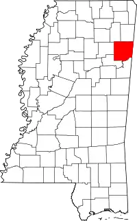
Location of Monroe County in Mississippi
This is intended to be a complete list of the properties and districts on the National Register of Historic Places in Monroe County, Mississippi, United States. Latitude and longitude coordinates are provided for many National Register properties and districts; these locations may be seen together in a map.[1]
There are 37 properties and districts listed on the National Register in the county, including 1 National Historic Landmark.
This National Park Service list is complete through NPS recent listings posted October 20, 2023.[2]
Current listings
| [3] | Name on the Register[4] | Image | Date listed[5] | Location | City or town | Description |
|---|---|---|---|---|---|---|
| 1 | Aberdeen City Hall | 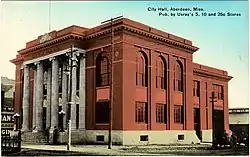 Aberdeen City Hall |
February 22, 1988 (#88000126) |
125 W. Commerce St. 33°49′30″N 88°32′41″W |
Aberdeen | |
| 2 | Aberdeen Downtown Historic District |  Aberdeen Downtown Historic District |
July 11, 1997 (#97000634) |
Roughly bounded by James, Quincy, Maple, and Washington Sts. 33°49′34″N 88°32′47″W |
Aberdeen | |
| 3 | Adams-French House | 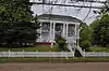 Adams-French House |
February 22, 1988 (#88000125) |
N. Meridian and Marshall Sts. 33°49′42″N 88°32′39″W |
Aberdeen | |
| 4 | Baker Mound | July 17, 1980 (#80002291) |
Address restricted[6] |
Aberdeen | ||
| 5 | Baptist Ville Historic District | October 16, 2023 (#100009439) |
Roughly bounded by Ben Bender Rd., Short., North Columbus, and West Vine Sts., and Woodcrest Dr. 33°49′54″N 88°33′03″W |
Aberdeen | ||
| 6 | 133 East Commerce Street | 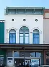 133 East Commerce Street |
February 22, 1988 (#88000136) |
133 E. Commerce St. 33°49′28″N 88°32′32″W |
Aberdeen | |
| 7 | Buildings at 110–122 East Commerce Street | 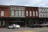 Buildings at 110–122 East Commerce Street |
February 22, 1988 (#88000138) |
110–122 E. Commerce St. 33°49′31″N 88°32′34″W |
Aberdeen | |
| 8 | 100 West Commerce | 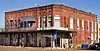 100 West Commerce |
February 22, 1988 (#88000135) |
100–104 W. Commerce St. and 107 N. Meridian St. 33°49′31″N 88°32′38″W |
Aberdeen | |
| 9 | Capt. Thomas Coopwood House | 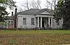 Capt. Thomas Coopwood House |
September 9, 2004 (#88000492) |
205 Thayer Ave. 33°49′25″N 88°33′42″W |
Aberdeen | |
| 10 | Cotton Gin Port Site |  Cotton Gin Port Site |
October 18, 1972 (#72000700) |
Along the Tombigbee River west of Amory[7] 33°58′15″N 88°32′35″W |
Amory | |
| 11 | Crawford Site | November 28, 1980 (#80002292) |
Address restricted[6] |
Aberdeen | ||
| 12 | Reuben Davis House |  Reuben Davis House |
November 16, 1978 (#78001622) |
803 W. Commerce St. 33°49′30″N 88°33′22″W |
Aberdeen | |
| 13 | C.C. Day House | 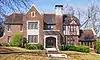 C.C. Day House |
February 22, 1988 (#88000123) |
517 S. Meridian St. 33°49′10″N 88°32′40″W |
Aberdeen | |
| 14 | William A. Dunklin House | William A. Dunklin House |
February 22, 1988 (#88000122) |
301 High St. 33°49′08″N 88°32′46″W |
Aberdeen | |
| 15 | Harmon Subdivision Historic District | April 22, 1988 (#88000121) |
933–939 and 943 W. Commerce St. 33°49′30″N 88°33′36″W |
Aberdeen | ||
| 16 | Hester-Standifer Creek Site | June 5, 1975 (#75001051) |
Address restricted[6] |
Amory | ||
| 17 | John Holliday House | 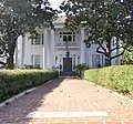 John Holliday House |
February 22, 1988 (#88000120) |
609 S. Meridian St. 33°49′07″N 88°32′39″W |
Aberdeen | |
| 18 | Inzer Site | July 5, 1973 (#73001022) |
Address restricted[6] |
Amory | ||
| 19 | Johnson-Butler House | Johnson-Butler House |
February 22, 1988 (#88000119) |
210 High St. 33°49′09″N 88°32′44″W |
Aberdeen | |
| 20 | Lawson Site | July 7, 1975 (#75001052) |
Address restricted[6] |
Amory | ||
| 21 | Lenoir Plantation House |  Lenoir Plantation House |
April 28, 1992 (#91001893) |
Off Alternate U.S. Route 45, 3 miles south of its junction with Mississippi Highway 382 33°45′12″N 88°41′19″W |
Prairie | |
| 22 | Mobile and Ohio Railroad Depot | 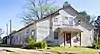 Mobile and Ohio Railroad Depot |
December 8, 1983 (#83003966) |
612 W. Commerce St. 33°49′34″N 88°33′05″W |
Aberdeen | |
| 23 | Monroe County Courthouse |  Monroe County Courthouse |
December 22, 1978 (#78001623) |
Courthouse Sq. 33°49′18″N 88°32′28″W |
Aberdeen | |
| 24 | Monroe County Jail | 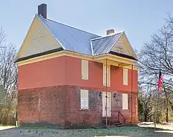 Monroe County Jail |
July 14, 1978 (#78001624) |
50001 Beeks 33°52′17″N 88°26′33″W |
Athens | Also known as Athens Jail |
| 25 | Mound Cemetery Site | October 14, 1975 (#75001053) |
Address restricted[6] |
Amory | ||
| 26 | North Aberdeen Historic District | April 22, 1988 (#88000131) |
Roughly bounded by Meridian, Marshall, Long, and Commerce Sts. 33°49′36″N 88°32′48″W |
Aberdeen | ||
| 27 | Old Homestead |  Old Homestead |
February 22, 1988 (#88000124) |
503 W. Commerce 33°49′29″N 88°32′56″W |
Aberdeen | |
| 28 | Francis M. Rogers House | 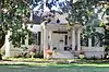 Francis M. Rogers House |
November 3, 1988 (#88002222) |
205 High St. 33°49′07″N 88°32′44″W |
Aberdeen | |
| 29 | Sadler House | 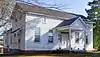 Sadler House |
March 21, 2011 (#11000113) |
400 Marshall St. 33°49′42″N 88°32′51″W |
Aberdeen | |
| 30 | The Saunders-Paine House | September 28, 2017 (#100001678) |
309 S. Matubba St. 33°49′22″N 88°33′09″W |
Aberdeen | ||
| 31 | South Central Aberdeen Historic District | April 22, 1988 (#88000134) |
Roughly bounded by Locust, Washington, Franklin, and High Sts.; also roughly bounded by Madison, Meridian, High, and Long Sts.; also roughly bounded by Commerce, Burnett, rear property lines of Franklin & W. side of S. Matubba Sts. 33°49′18″N 88°32′49″W |
Aberdeen | Second and third set of boundaries represents a boundary increase of September 10, 2004 and September 28, 2017 | |
| 32 | James Young Thompson House |  James Young Thompson House |
August 16, 1990 (#90001223) |
Old Cotton Gin Rd., ¼ mile north of U.S. Route 278 33°59′07″N 88°31′40″W |
Amory | |
| 33 | U.S. Courthouse and Post Office | 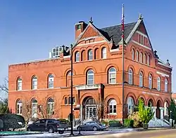 U.S. Courthouse and Post Office |
September 29, 1976 (#76001104) |
201 W. Commerce St. 33°49′29″N 88°32′41″W |
Aberdeen | |
| 34 | US Post Office-Amory |  US Post Office-Amory |
April 11, 1988 (#88000691) |
215 1st Ave. 33°59′09″N 88°29′18″W |
Amory | |
| 35 | W.W. Watkins House |  W.W. Watkins House |
April 5, 1991 (#91000387) |
600 W. Commerce St. 33°49′32″N 88°33′03″W |
Aberdeen | |
| 36 | West Commerce Street Historic District |  West Commerce Street Historic District |
April 19, 1988 (#88000128) |
721–919 and 730–900 W. Commerce St. 33°49′31″N 88°33′20″W |
Aberdeen | |
| 37 | Word Mound | July 17, 1980 (#80002293) |
Address restricted[6] |
Aberdeen |
See also
Wikimedia Commons has media related to National Register of Historic Places in Monroe County, Mississippi.
References
- The latitude and longitude information provided in this table was derived originally from the National Register Information System, which has been found to be fairly accurate for about 99% of listings. Some locations in this table may have been corrected to current GPS standards.
- National Park Service, United States Department of the Interior, "National Register of Historic Places: Weekly List Actions", retrieved October 20, 2023.
- Numbers represent an alphabetical ordering by significant words. Various colorings, defined here, differentiate National Historic Landmarks and historic districts from other NRHP buildings, structures, sites or objects.
- "National Register Information System". National Register of Historic Places. National Park Service. March 13, 2009.
- The eight-digit number below each date is the number assigned to each location in the National Register Information System database, which can be viewed by clicking the number.
- Federal and state laws and practices restrict general public access to information regarding the specific location of this resource. In some cases, this is to protect archeological sites from vandalism, while in other cases it is restricted at the request of the owner. See: Knoerl, John; Miller, Diane; Shrimpton, Rebecca H. (1990), Guidelines for Restricting Information about Historic and Prehistoric Resources, National Register Bulletin, National Park Service, U.S. Department of the Interior, OCLC 20706997.
- Location derived from its GNIS feature record; the NRIS lists the site as "Address Restricted"
| Topics | |
|---|---|
| Lists by state |
|
| Lists by insular areas | |
| Lists by associated state | |
| Other areas | |
| Related | |
Municipalities and communities of Monroe County, Mississippi, United States | ||
|---|---|---|
| Cities | Map of Mississippi highlighting Monroe County | |
| Towns | ||
| Village | ||
| CDPs | ||
| Other communities | ||
| Ghost towns | ||
| Footnotes | ‡This town also has portions in adjacent county or counties | |
This article is issued from Wikipedia. The text is licensed under Creative Commons - Attribution - Sharealike. Additional terms may apply for the media files.