National Register of Historic Places listings in Livingston County, Illinois
This is a list of the National Register of Historic Places listings in Livingston County, Illinois.
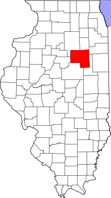
Location of Livingston County in Illinois
This is intended to be a complete list of the properties and districts on the National Register of Historic Places in Livingston County, Illinois, United States. Latitude and longitude coordinates are provided for many National Register properties and districts; these locations may be seen together in a map.[1]
There are 15 properties and districts listed on the National Register in the county.
This National Park Service list is complete through NPS recent listings posted October 20, 2023.[2]
Current listings
| [3] | Name on the Register | Image | Date listed[4] | Location | City or town | Description |
|---|---|---|---|---|---|---|
| 1 | Ambler's Texaco Gas Station | 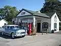 Ambler's Texaco Gas Station |
November 29, 2001 (#01001311) |
Il 17 and Old US 66 41°05′39″N 88°26′26″W |
Dwight | |
| 2 | Thomas A. Beach House | 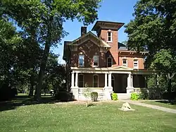 Thomas A. Beach House |
July 28, 1983 (#83000324) |
402 E. Hickory St. 40°45′00″N 88°30′30″W |
Fairbury | |
| 3 | Dwight Chicago and Alton Railroad Depot | 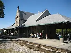 Dwight Chicago and Alton Railroad Depot |
December 27, 1982 (#82000398) |
East St. 41°05′10″N 88°25′43″W |
Dwight | |
| 4 | Fairbury City Hall | 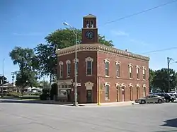 Fairbury City Hall |
February 16, 1996 (#96000090) |
101 E. Locust St. 40°44′48″N 88°30′46″W |
Fairbury | |
| 5 | Illinois State Police Office, Pontiac | 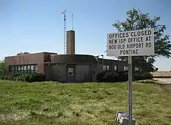 Illinois State Police Office, Pontiac |
March 7, 2007 (#07000117) |
15551 Old US 66 40°51′11″N 88°39′20″W |
Pontiac | |
| 6 | Jones House | 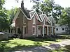 Jones House |
May 5, 1978 (#78001163) |
314 E. Madison St. 40°52′46″N 88°37′33″W |
Pontiac | |
| 7 | Livingston County Courthouse |  Livingston County Courthouse |
November 19, 1986 (#86003165) |
112 W. Madison 40°52′47″N 88°37′45″W |
Pontiac | |
| 8 | Memorial Bandstand of Long Point | April 13, 2023 (#100008844) |
Village Park bordered by Main, 4th, 3rd and Park Sts. 41°00′20″N 88°53′36″W |
Long Point | ||
| 9 | John R. Oughton House | 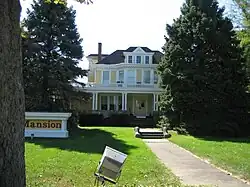 John R. Oughton House |
September 23, 1980 (#80001383) |
101 W. South St. 41°05′09″N 88°25′43″W |
Dwight | |
| 10 | Pioneer Gothic Church | 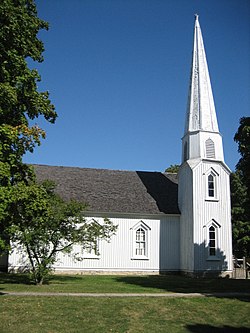 Pioneer Gothic Church |
July 28, 1983 (#83000325) |
201 N. Franklin St. 41°05′40″N 88°25′43″W |
Dwight | |
| 11 | Pontiac City Hall and Fire Station | 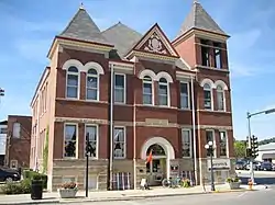 Pontiac City Hall and Fire Station |
August 16, 1990 (#90001200) |
110 W. Howard St. 40°52′51″N 88°37′44″W |
Pontiac | |
| 12 | Route 66, Cayuga to Chenoa |  Route 66, Cayuga to Chenoa |
July 23, 2003 (#99000115) |
Rte 66, bet just N of Township Rd 2200 N and just S of Township Rd 3000 N. 40°45′12″N 88°43′07″W |
Pontiac | |
| 13 | Raymond Schulz Round Barn | 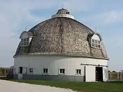 Raymond Schulz Round Barn |
August 26, 1982 (#82002582) |
S of Pontiac off US 66 40°50′28″N 88°38′30″W |
Pontiac | |
| 14 | Standard Oil Gasoline Station | 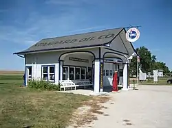 Standard Oil Gasoline Station |
November 9, 1997 (#97001338) |
400 S. West St. 41°00′07″N 88°31′44″W |
Odell | |
| 15 | Strevell House | April 12, 2023 (#100008845) |
401 West Livingston St. 40°52′56″N 88°37′56″W |
Pontiac |
See also
Wikimedia Commons has media related to National Register of Historic Places in Livingston County, Illinois.
References
- The latitude and longitude information provided in this table was derived originally from the National Register Information System, which has been found to be fairly accurate for about 99% of listings. Some locations in this table may have been corrected to current GPS standards.
- National Park Service, United States Department of the Interior, "National Register of Historic Places: Weekly List Actions", retrieved October 20, 2023.
- Numbers represent an alphabetical ordering by significant words. Various colorings, defined here, differentiate National Historic Landmarks and historic districts from other NRHP buildings, structures, sites or objects.
- The eight-digit number below each date is the number assigned to each location in the National Register Information System database, which can be viewed by clicking the number.

This article is issued from Wikipedia. The text is licensed under Creative Commons - Attribution - Sharealike. Additional terms may apply for the media files.