National Register of Historic Places listings in Saunders County, Nebraska
This is a list of the National Register of Historic Places listings in Saunders County, Nebraska. It is intended to be a complete list of the properties and districts on the National Register of Historic Places in Saunders County, Nebraska, United States. The locations of National Register properties and districts for which the latitude and longitude coordinates are included below, may be seen in a map.[1]
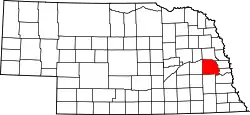
Location of Saunders County in Nebraska
There are 20 properties and districts listed on the National Register in the county, and two former listings.
This National Park Service list is complete through NPS recent listings posted October 20, 2023.[2]
Listings county-wide
| [3] | Name on the Register | Image | Date listed[4] | Location | City or town | Description |
|---|---|---|---|---|---|---|
| 1 | Ashland Archeological District | November 29, 2000 (#00001376) |
Address Restricted |
Ashland | ||
| 2 | Ashland Public Library | 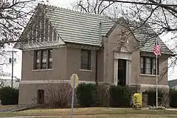 Ashland Public Library |
January 27, 1983 (#83001102) |
207 N. 15th St. 41°02′27″N 96°22′08″W |
Ashland | |
| 3 | Barnes Oil Company | 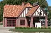 Barnes Oil Company |
December 5, 2002 (#02001475) |
Junction of Silver St. and U.S. Route 6 41°02′20″N 96°21′26″W |
Ashland | |
| 4 | Camp Ashland Memorial Hall | March 11, 2021 (#100006287) |
220 Cty. Rd. A (Camp Ashland) 41°03′46″N 96°20′06″W |
Ashland | ||
| 5 | Howard Hanson House | 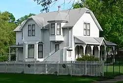 Howard Hanson House |
January 27, 1983 (#83001103) |
12th and Linden Sts. 41°12′59″N 96°37′07″W |
Wahoo | |
| 6 | Hoffman Building | Hoffman Building |
November 21, 2014 (#14000441) |
1325 & 1341 Silver St. 41°02′20″N 96°22′06″W |
Ashland | |
| 7 | Old Ithaca Grain Elevator | 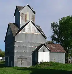 Old Ithaca Grain Elevator |
February 23, 2001 (#01000168) |
One block south of 4th St. 41°09′27″N 96°32′19″W |
Ithaca | |
| 8 | Kacirek-Woita General Store | 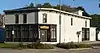 Kacirek-Woita General Store |
July 8, 2014 (#14000397) |
250 N. Elm St. 41°11′30″N 96°44′36″W |
Weston | |
| 9 | F.J. Kirchman House | _from_NE_2.JPG.webp) F.J. Kirchman House |
August 21, 2003 (#03000796) |
957 Beech St. 41°12′52″N 96°37′02″W |
Wahoo | |
| 10 | Leshara Site | March 16, 1972 (#72000759) |
Address Restricted |
Leshara | ||
| 11 | McClean Site | March 16, 1972 (#72000758) |
Address Restricted |
Inglewood | ||
| 12 | National Bank of Ashland | 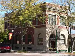 National Bank of Ashland |
January 27, 1983 (#83001104) |
1442 Silver St. 41°02′21″N 96°22′09″W |
Ashland | |
| 13 | O.K. Market | _1.jpg.webp) O.K. Market |
July 3, 1991 (#91000835) |
542 N. Linden Ave. 41°12′38″N 96°36′23″W |
Wahoo | |
| 14 | Pahuk | Pahuk |
August 14, 1973 (#73001074) |
Address Restricted |
Cedar Bluffs | |
| 15 | Rad Plzen cis. 9 Z.C.B.J. (SD10-6) | 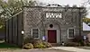 Rad Plzen cis. 9 Z.C.B.J. (SD10-6) |
March 20, 1986 (#86000440) |
Off Nebraska Highway 79 41°25′52″N 96°45′58″W |
Morse Bluff | |
| 16 | St. Stephen's Episcopal Church | 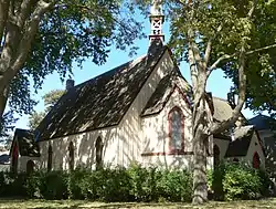 St. Stephen's Episcopal Church |
January 25, 1979 (#79001454) |
16th and Adams Sts.[5] 41°02′25″N 96°22′16″W |
Ashland | |
| 17 | Saunders County Courthouse | 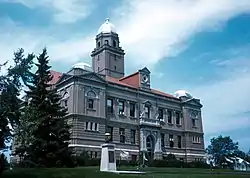 Saunders County Courthouse |
January 10, 1990 (#89002220) |
Chestnut between 4th and 5th Sts. 41°12′34″N 96°37′24″W |
Wahoo | |
| 18 | Wahoo Burlington Depot | 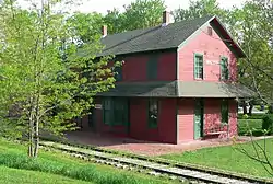 Wahoo Burlington Depot |
May 9, 1985 (#85000955) |
431 W. 3rd 41°12′27″N 96°36′44″W |
Wahoo | |
| 19 | Woodcliff Burials | March 7, 1973 (#73001075) |
Address Restricted |
Inglewood | ||
| 20 | Yutan Site | June 26, 1972 (#72000760) |
Address Restricted |
Yutan |
Former listings
| [3] | Name on the Register | Image | Date listed | Date removed | Location | City or town | Description |
|---|---|---|---|---|---|---|---|
| 1 | Ashland Bridge | Ashland Bridge |
June 29, 1992 (#92000721) | March 3, 2023 | Silver St. over Salt Creek 41°02′21″N 96°21′52″W |
Ashland | One of 2 surviving Warren pony truss bridges in Nebraska |
| 2 | Israel Beetison House | 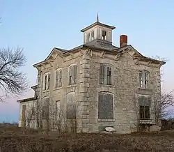 Israel Beetison House |
April 18, 1977 (#77000839) | March 3, 2023 | Southeast of Ashland 41°01′54″N 96°21′12″W |
Ashland |
See also
Wikimedia Commons has media related to National Register of Historic Places in Saunders County, Nebraska.
References
- The latitude and longitude information provided in this table was derived originally from the National Register Information System, which has been found to be fairly accurate for about 99% of listings. Some locations in this table may have been corrected to current GPS standards.
- National Park Service, United States Department of the Interior, "National Register of Historic Places: Weekly List Actions", retrieved October 20, 2023.
- Numbers represent an alphabetical ordering by significant words. Various colorings, defined here, differentiate National Historic Landmarks and historic districts from other NRHP buildings, structures, sites or objects.
- The eight-digit number below each date is the number assigned to each location in the National Register Information System database, which can be viewed by clicking the number.
- See photo.
| Topics |  | |
|---|---|---|
| Lists by county |
| |
| Other lists |
| |
Municipalities and communities of Saunders County, Nebraska, United States | ||
|---|---|---|
| Cities | Map of Nebraska highlighting Saunders County | |
| Villages | ||
| Townships | ||
| CDP | ||
| Unincorporated communities | ||
This article is issued from Wikipedia. The text is licensed under Creative Commons - Attribution - Sharealike. Additional terms may apply for the media files.