National Register of Historic Places listings in Winston County, Mississippi
This is a list of the National Register of Historic Places listings in Winston County, Mississippi.
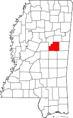
Location of Winston County in Mississippi
This is intended to be a complete list of the properties and districts on the National Register of Historic Places in Winston County, Mississippi, United States. Latitude and longitude coordinates are provided for many National Register properties and districts; these locations may be seen together in a map.[1]
There are 8 properties and districts listed on the National Register in the county.
This National Park Service list is complete through NPS recent listings posted October 13, 2023.[2]
Current listings
| [3] | Name on the Register | Image | Date listed[4] | Location | City or town | Description |
|---|---|---|---|---|---|---|
| 1 | Baptist Church of Christ at Sardis | 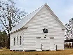 Baptist Church of Christ at Sardis |
March 21, 2011 (#11000110) |
2185 Sardis Rd. 33°03′20″N 88°51′13″W |
Louisville vicinity | |
| 2 | Downtown Louisville Historic District | July 20, 2011 (#11000473) |
Bounded by Church St., W. Park St., Columbus Ave. & Mill St. 33°07′25″N 89°03′16″W |
Louisville | ||
| 3 | Foster-Fair House | 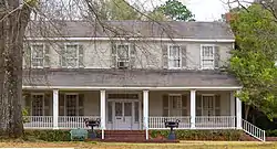 Foster-Fair House |
November 29, 2000 (#00000332) |
507 S. Columbus Ave. 33°07′04″N 89°03′09″W |
Louisville | |
| 4 | Legion State Park | Legion State Park |
November 5, 1998 (#98001333) |
635 Legion State Park Rd. 33°09′05″N 89°02′41″W |
Louisville | |
| 5 | Old Masonic Hall | 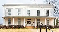 Old Masonic Hall |
February 25, 1994 (#94000065) |
302 W. Park St. 33°07′19″N 89°03′22″W |
Louisville | |
| 6 | Nanih Waiya Mound And Village |  Nanih Waiya Mound And Village |
March 28, 1973 (#73001032) |
Along Mississippi Highway 393 in Nanih Waiya State Park[5] 32°55′15″N 88°56′55″W |
Fearns Springs | |
| 7 | Old Robinson Road | April 3, 1975 (#75001061) |
16.6 miles northeast of Louisville in the Noxubee National Wildlife Refuge 33°16′32″N 88°49′52″W |
Louisville | ||
| 8 | Benjamin Franklin Smyth House | 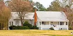 Benjamin Franklin Smyth House |
February 25, 1994 (#94000064) |
227 Smyth Rd. 33°05′52″N 89°04′24″W |
Louisville |
See also
Wikimedia Commons has media related to National Register of Historic Places in Winston County, Mississippi.
References
- The latitude and longitude information provided in this table was derived originally from the National Register Information System, which has been found to be fairly accurate for about 99% of listings. Some locations in this table may have been corrected to current GPS standards.
- National Park Service, United States Department of the Interior, "National Register of Historic Places: Weekly List Actions", retrieved October 13, 2023.
- Numbers represent an alphabetical ordering by significant words. Various colorings, defined here, differentiate National Historic Landmarks and historic districts from other NRHP buildings, structures, sites or objects.
- The eight-digit number below each date is the number assigned to each location in the National Register Information System database, which can be viewed by clicking the number.
- Location derived from the GNIS feature record for Nanih Waiya State Park; the NRIS lists the site as "Address Restricted"
Municipalities and communities of Winston County, Mississippi, United States | ||
|---|---|---|
| Cities | Map of Mississippi highlighting Winston County | |
| Towns | ||
| Unincorporated communities | ||
| Ghost towns | ||
| Indian reservation | ||
| Footnotes | ‡This populated place also has portions in an adjacent county or counties | |
| Topics | |
|---|---|
| Lists by state |
|
| Lists by insular areas | |
| Lists by associated state | |
| Other areas | |
| Related | |
This article is issued from Wikipedia. The text is licensed under Creative Commons - Attribution - Sharealike. Additional terms may apply for the media files.