National road 68 (Poland)
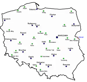
National road 68 (Polish: Droga krajowa nr 68, abbreviated as DK68) is a main road of accelerated traffic (Polish: droga główna ruchu przyspieszonego)[1] belonging to the Polish national road network. The length of the route is 11.4 kilometres (7.1 mi), of which 5.197 kilometres (3.229 mi) is maintained by General Directorate for National Roads and Highways (Polish: Generalna Dyrekcja Dróg Krajowych i Autostrad, abbreviated as GDDKiA).[2] The highway connects the Kukuryki border crossing on Belarus–Poland border with national road 2 in Wólka Dobryńska. It runs entirely in Lublin Voivodeship, in Biała County (Terespol and Zalesie gminas). According to signage, national road 68 is a component of European highway E30.
 | ||||
|---|---|---|---|---|
| Droga krajowa nr 68 | ||||
 | ||||
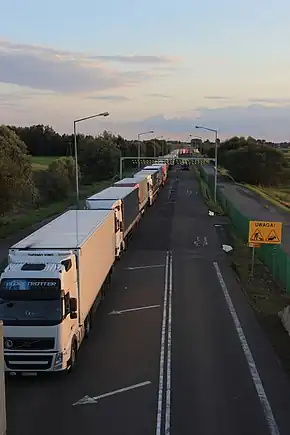
 National road 68 seen from the viaduct of voivodeship road 698, in direction to Wólka Dobryńska | ||||
| Route information | ||||
| Maintained by GDDKiA (on 5.197 kilometres (3.229 mi)) | ||||
| Length | 11.4 km (7.1 mi) | |||
| Major junctions | ||||
| From | ||||
| To | Wólka Dobryńska | |||
| Location | ||||
| Country | Poland | |||
| Regions | Lublin Voivodeship | |||
| Highway system | ||||
| ||||
From February 14, 1986[3] until the road network reform in 2000, the route was signed as national road 812.[4]
In the years 2005[5] – 2007,[6] the road was reconstructed, as part of which, among others, the surface was renewed and strengthened to a load of 115 kN/axle.[7] Also a concrete parking lane was built, 4 metres (13 ft) wide and approximately 5 kilometres (3.1 mi) long, stretching from the intersection with national road 2 in Wólka Dobryńska to the car terminal in Koroszczyn. The stretch from Koroszczyn terminal to the border crossing is accessible only for large goods vehicles and overlaps with planned course of motorway A2.[8]
Permissible axle load
From November 15, 2005[9] the entire route is accessible for vehicles with single axle load up to 11.5 tons,[10][11] while previously it was up to 10 tons.[12][13][14]
Localities along the route
- Kukuryki, border with Belarus
- Koroszczyn
- Wólka Dobryńska (road 2)
References
- Zarządzenie nr 34 Generalnego Dyrektora Dróg Krajowych i Autostrad z dnia 3 października 2017 r. w sprawie klas istniejących dróg krajowych [Ordinance No. 34 of the General Director for National Roads and Motorways of October 3, 2017 on the classes of existing national roads] (PDF) (in Polish), Generalna Dyrekcja Dróg Krajowych i Autostrad, retrieved 2022-12-19
- Sieć Dróg Krajowych [National Roads Network] (in Polish), Generalna Dyrekcja Dróg Krajowych i Autostrad Oddział w Lublinie, retrieved 2022-12-19
- Uchwała nr 192 Rady Ministrów z dnia 3 grudnia 1985 r. w sprawie zaliczenia dróg do kategorii dróg krajowych. [Resolution No. 192 of the Council of Ministers of 3 December 1985 on classifying roads as national roads.], M.P. z 1986 r. Nr 3, poz. 16
- Rozporządzenie Rady Ministrów z dnia 15 grudnia 1998 r. w sprawie ustalenia wykazu dróg krajowych i wojewódzkich (Dz.U. z 1998 r. nr 160, poz. 1071) [Regulation of the Council of Ministers of 15 December 1998 on establishing a list of national and voivodship roads], Dz. U. z 1998 r. Nr 160, poz. 1071
- Rusza budowa drogi nr 68 Kukuryki - Wólka Dobryńska [The construction of road no 68 Kukuryki - Wólka Dobryńska begins] (in Polish), Generalna Dyrekcja Dróg Krajowych i Autostrad, 2005-06-28, retrieved 2022-12-19
- Przebudowa drogi krajowej nr 68 [The reconstruction of national road 68] (in Polish), kukuryki.pl, 2007-01-22, archived from the original on 2007-05-24
{{citation}}: CS1 maint: unfit URL (link) - Przebudowa drogi krajowej nr 68 - zakres opracowania [The reconstruction of national road 68 - scope of the study] (in Polish), kukuryki.pl, 2007-01-22, archived from the original on 2008-02-01
{{citation}}: CS1 maint: unfit URL (link) - Ruszamy z przetargiem na A2 od Białej Podlaskiej do granicy państwa [We are launching a tender for A2 from Biała Podlaska to country border] (in Polish), GDDKiA, 2020-12-30, retrieved 2022-12-19
- Rozporządzenie Ministra Infrastruktury z dnia 19 października 2005 r. w sprawie wykazu dróg krajowych, po których mogą się poruszać pojazdy o dopuszczalnym nacisku pojedynczej osi napędowej do 11,5 t [Ordinance of the Minister of Infrastructure of 19 October 2005 on the list of national roads on which vehicles with a permissible single drive axle load of up to 11.5 t may travel], Dz. U. z 2005 r. Nr 219, poz. 1860
- Ustawa z dnia 18 grudnia 2020 r. o zmianie ustawy o drogach publicznych oraz niektórych innych ustaw [Act of December 18, 2020 amending the act on public roads and some other acts], Dz. U. z 2021 r. poz. 54
-
Art. 41. 1. On public roads it is allowed to drive vehicles with a single drive axle load of up to 11.5 t, taking into account art. 41a sec. 1 and with the exception specified in art. 41b sec. 1. 2. It is allowed to introduce or establish a ban on the movement of vehicles with a permissible single drive axle load above 10 t or above 8 t:
–, Obwieszczenie Marszałka Sejmu Rzeczypospolitej Polskiej z dnia 25 czerwca 2021 r. w sprawie ogłoszenia jednolitego tekstu ustawy o drogach publicznych [Announcement of the Marshal of the Sejm of the Republic of Poland of June 25, 2021 on the publication of the consolidated text of the Act on Public Roads], Dz. U. z 2022 r. poz. 1693
1) along a specific public road or its section,
2) in a zone covering at least two public roads or sections thereof – hereinafter referred to as "the ban". (...) 7. It is forbidden to introduce or establish the ban on:
(...)
3) national roads or their sections, with the exception of national roads managed by mayors of cities with powiat rights. (...) - Polska: mapa samochodowa 1:700 000 [Poland: road map 1:700 000] (in Polish) (1 ed.), Szczecin: Wydawnictwo Kartograficzne KOMPAS, 1996–1997, ISBN 83-904373-2-5
- Polska: mapa samochodowa 1:700 000 [Poland: road map 1:700 000] (in Polish) (II Zmienione i poprawione ed.), Szczecin: Wydawnictwo Kartograficzne KOMPAS, 1997–1998, ISBN 83-904373-3-3
- Rozporządzenie Ministra Infrastruktury z dnia 28 marca 2003 r. w sprawie sieci dróg krajowych, po których mogą poruszać się pojazdy o określonych parametrach [Regulation of the Minister of Infrastructure of March 28, 2003 on the network of national roads on which vehicles with specific parameters can travel], Dz. U. z 2003 r. Nr 62, poz. 563