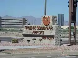
Phoenix Goodyear Airport
Phoenix Goodyear Airport (IATA: GYR, ICAO: KGYR, FAA LID: GYR) (formerly Goodyear Municipal Airport) is a public airport in Goodyear, Arizona in Maricopa County, Arizona, United States.
Phoenix Goodyear Airport | |||||||||||
|---|---|---|---|---|---|---|---|---|---|---|---|
 | |||||||||||
| Summary | |||||||||||
| Airport type | Public | ||||||||||
| Owner | City of Phoenix | ||||||||||
| Serves | Phoenix, Arizona | ||||||||||
| Location | Goodyear, United States | ||||||||||
| Hub for |
| ||||||||||
| Elevation AMSL | 971 ft / 296 m | ||||||||||
| Coordinates | 33°25′41″N 112°22′28″W | ||||||||||
| Website | goodyearairport.com | ||||||||||
| Map | |||||||||||
 GYR  GYR | |||||||||||
| Runways | |||||||||||
| |||||||||||
| Helipads | |||||||||||
| |||||||||||
| Statistics (2020) | |||||||||||
| |||||||||||
History
It was built during World War II as a naval air facility, NAF Litchfield Park, then upgraded to naval air station status and renamed NAS Litchfield Park.[2] Its primary role after the end of World War II was storage and preservation of obsolete or excess U.S. Navy, U.S. Marine Corps and U.S. Coast Guard aircraft.[3] In 1968, all Department of Defense and U.S. Coast Guard aircraft preservation and storage was consolidated at the Military Aircraft Storage and Disposition Center (MASDC) at Davis-Monthan AFB in Tucson and NAS Litchfield Park was slated for closure.

Following the closure of NAS Litchfield Park in 1968, the Goodyear company discussed using it as its Aviation Products Division. The airport is not served by any airlines. Ultimately, the city of Phoenix purchased the airport as a general aviation reliever airport for Phoenix Sky Harbor International Airport.[4] The airport is, however, a major keep and maintenance spot, and the aircraft of many airlines, both domestic and international, can be spotted there.[5]
Phoenix-Goodyear Airport is a Superfund site due to a number of soil and groundwater contaminants from its time as a military installation.[6]
Facilities
Phoenix Goodyear Airport covers 789 acres (319 ha) at an elevation of 971 ft (296 m) above mean sea level. GYR has one asphalt runway and one concrete helipad:
- Runway 3/21 measuring 8,500 ft × 150 ft (2,591 m × 46 m)
- Helipad H1, measuring 64 ft × 64 ft (20 m × 20 m)[1]
In 2020 the airport had 79,599 aircraft operations, average 218 per day: 94% general aviation, <1% airline, 1% military and 4% air taxi. 215 aircraft were based at the airport: 183 single engine, 6 multi-engine, 19 jet, 6 military, and 1 helicopter.[1]
Resident companies
The airfield is home to several companies offering aircraft maintenance and commercial pilot training:
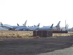
- AerSale, Inc. operates a maintenance facility on the airfield which comprises maintenance, storage and disposal. The northern side of the airfield is used for storage and many Boeing 737, Airbus A340 and Boeing 747s are visible from the road as they await their fate.
- Airline Training Center Arizona (ATCA) was the training facility for the Lufthansa Flight Training of German Lufthansa Airlines. Basic flight training for German Air Force student pilots was also conducted in Grob G 120 aircraft.
- Oxford Aviation Academy (OAA) is the US name for Oxford Aviation Academy, a British company specializing in training airline pilots for United Kingdom, British Airways and other European airlines. OAA moved to Falcon Field in October 2013 and is no longer based at KGYR.
Both flight training schools, while regulated by the FAA and operating under their regulations, train students to JAA requirements as required for Europe.
From 2014 CTC Wings aviation academy started to use the airport as training facility in addition to its center in Hamilton, New Zealand.
Operational statistics
| Type of operation | Number |
|---|---|
| Single-engine aircraft based on field | 183 |
| Multi-engine aircraft based on field | 6 |
| Annual commercial operations | 184 |
| Jet aircraft based on field | 19 |
| Annual commuter operations | none |
| Helicopters based on field | 1 |
| Annual air taxi operations | 3,324 |
| Military aircraft based on field | 6 |
| Annual military operations | 1,175 |
| Gliders based on field | none |
| Annual GA local operations | 45,189 |
| Ultralights based on field | none |
| Annual GA itinerant operations | 29,727 |
Through December 31, 2020.
Gallery
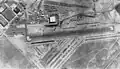 Aerial view in 1950
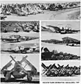 Different aircraft types stored in 1959
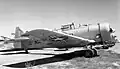 SNJs at Litchfield Park in 1960
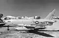 FJ-4F in 1960
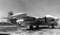 AJ-2 in the 1960s
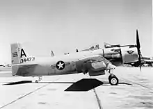

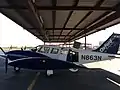
 A former Lufthansa Flight Training Bonanza 33
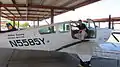
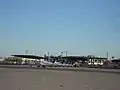 Oxford Aviation Academy's airplanes Piper PA-28 Warrior, as seen from the apron
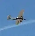 A Ford Trimotor landing at Phoenix Goodyear Airport during March 2017
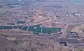 A recent view of Phoenix Goodyear Airport
References
- FAA Airport Form 5010 for GYR PDF, effective 2023-01-26
- Cook, James E. (December 2, 1986). "Goodyear cuts deep tracks in Arizona history". Newspapers.com. Retrieved 2023-09-11.
- "NAS Litchfield Park". Flickr.
- Dean, Paul (February 4, 1968). "Litchfield ready for mufti and golden eagle on label". Newspapers.com. Retrieved 2023-09-11.
- "Goodyear Photos Page 1". www.visitingphx.com.
- US EPA, OSRTI. "PHOENIX-GOODYEAR AIRPORT AREA Site Profile". cumulis.epa.gov. Retrieved 2023-09-11.
External links
- Phoenix Goodyear Airport (official site)
- Phoenix Goodyear Airport (GYR) at Arizona DOT airport directory
- Air Traffic Activity System (ATADS) (FAA Statistical Data)
- FAA Airport Diagram (PDF), effective October 5, 2023
- FAA Terminal Procedures for GYR, effective October 5, 2023
- Resources for this airport:
- FAA airport information for GYR
- AirNav airport information for KGYR
- ASN accident history for GYR
- FlightAware airport information and live flight tracker
- NOAA/NWS weather observations: current, past three days
- SkyVector aeronautical chart, Terminal Procedures