Neighborhoods in Cleveland
Neighborhoods in Cleveland refer to the 34 neighborhood communities of the city of Cleveland, Ohio, as defined by the Cleveland City Planning Commission.[1][2] Based on historical definitions and census data, the neighborhoods serve as the basis for various urban planning initiatives on both the municipal and metropolitan levels.[2] Technically known as Statistical Planning Areas (SPAs), they also provide a "framework for summarizing socio-economic and other statistics within the city."[2] City neighborhood boundaries were last revised by the City Planning Commission in 2012.[2]

Cleveland's neighborhoods are generally defined by their position on either the East Side or West Side of the Cuyahoga River.[3] Downtown and Cuyahoga Valley are situated between the East and West Sides, while the Broadway–Slavic Village neighborhood is sometimes referred to as the South Side.[4]
Neighborhoods
| No. | Neighborhood[5] | Location | Map |
|---|---|---|---|
| 01 | Bellaire–Puritas | West Side (West Park) | 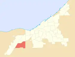 |
| 02 | Broadway–Slavic Village | South and East Side | 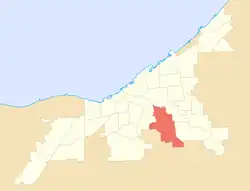 |
| 03 | Brooklyn Centre | West Side |  |
| 04 | Buckeye–Shaker | East Side |  |
| 05 | Buckeye–Woodhill | East Side |  |
| 06 | Central | East Side |  |
| 07 | Clark–Fulton | West Side | 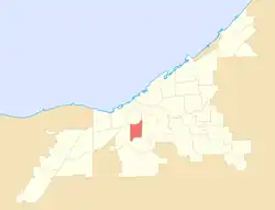 |
| 08 | Collinwood–Nottingham | East Side (Collinwood) | 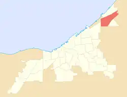 |
| 09 | Cudell | West Side |  |
| 10 | Cuyahoga Valley[lower-alpha 1] | Central and South Side | 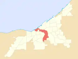 |
| 11 | Detroit–Shoreway | West Side | 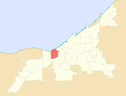 |
| 12 | Downtown[lower-alpha 2] | City Center | 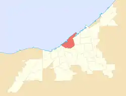 |
| 13 | Edgewater | West Side |  |
| 14 | Euclid–Green | East Side | 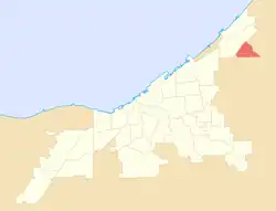 |
| 15 | Fairfax | East Side | 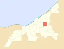 |
| 16 | Glenville | East Side |  |
| 17 | Goodrich–Kirtland Park[lower-alpha 3] | East Side |  |
| 18 | Hopkins | West Side (West Park) | 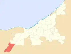 |
| 19 | Hough | East Side | 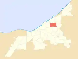 |
| 20 | Jefferson | West Side (West Park) | 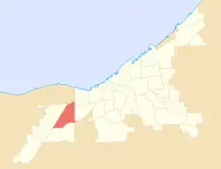 |
| 21 | Kamm's Corners | West Side (West Park) |  |
| 22 | Kinsman | East Side |  |
| 23 | Lee–Harvard | East Side (Lee–Miles) |  |
| 24 | Lee–Seville | East Side (Lee–Miles) |  |
| 25 | Mount Pleasant | East Side |  |
| 26 | North Shore Collinwood | East Side (Collinwood) | 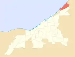 |
| 27 | Ohio City | West Side |  |
| 28 | Old Brooklyn | West Side |  |
| 29 | St. Clair–Superior | East Side |  |
| 30 | Stockyards | West Side | 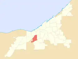 |
| 31 | Tremont[lower-alpha 4] | West Side | 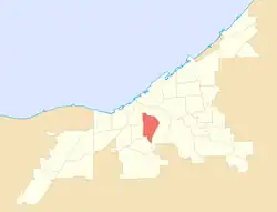 |
| 32 | Union–Miles Park | East Side | 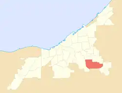 |
| 33 | University[lower-alpha 5] | East Side |  |
| 34 | West Boulevard | West Side |  |
Notes
- Includes Whiskey Island and The Flats.
- Downtown districts include the Campus District, Civic Center, East 4th Street, Gateway District, Nine-Twelve District, North Coast Harbor, Playhouse Square, Superior Arts District, Warehouse District, and historically Short Vincent.
- Includes Asiatown.
- Includes Duck Island.
- Includes Little Italy.
References
- "About". Cleveland City Planning Commission. Retrieved July 20, 2021.
- "Urban Tree Canopy Assessment Update: Cleveland Neighborhoods". Cuyahoga County Planning Commission. Retrieved July 20, 2021.
- Condon, George E. (1967). Cleveland: The Best Kept Secret. New York: Doubleday. p. 9.
For all practical purposes, though – and hang the technicalities – everything east of the [Cuyahoga] river constitutes the East Side. Everything west of the river can be considered the West Side. That is the realistic view taken by Clevelanders. When two Clevelanders meet for the first time, they fence conversationally until the vital question of East or West is answered. Knowing which side of town a new acquaintance comes from makes a subtle difference.
- Nalewicki, Jennifer (July 27, 2018). "Vibrant Art Installations Infuse New Life into Abandoned Houses in This Cleveland Neighborhood". Smithsonian. Retrieved June 5, 2023.
A symphony of hammers, saws and chisels pierce the early-morning silence that had blanketed Slavic Village, a neighborhood tucked away on Cleveland's south side.
- "Community Fact Sheets: Cleveland Neighborhoods and Wards". The Center for Community Solutions (Cleveland). Retrieved June 5, 2022.
External links
- Cleveland Neighborhoods, Destination Cleveland
- Get To Know Cleveland's Neighborhoods, 2023 article compilation by The Plain Dealer newspaper
- Neighborhoods and Landmarks, The Encyclopedia of Cleveland History (Case Western Reserve University)
- Current Cleveland Neighborhood Maps, Northern Ohio Data and Information Service (NODIS), Levin College of Urban Affairs (Cleveland State University)