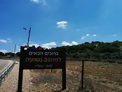
Netu'a
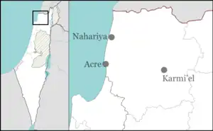
Netu'a (Hebrew: נְטוּעָה, lit. 'Planted') is a moshav in northern Israel. Located near the Lebanese border, it falls under the jurisdiction of Ma'ale Yosef Regional Council. In 2021 it had a population of 327.[1]
Netu'a | |
|---|---|
 | |
| Etymology: "Planted" | |
 Netu'a  Netu'a | |
| Coordinates: 33°3′53″N 35°19′22″E | |
| Country | |
| District | Northern |
| Council | Ma'ale Yosef |
| Affiliation | Moshavim Movement |
| Founded | 1966 |
| Founded by | Moshavniks |
| Population (2021)[1] | 327 |
History
The village was established in 1966 by residents of other local moshavim as part of a plan to encourage more Jewish settlement in the Galilee. It is located on the land of the Palestinian villages of Dayr al-Qassi and Al-Mansura,[2] both depopulated in the 1948 Arab–Israeli War.
During the 2023 war between Hamas and Israel, northern Israeli border communities, including Netu'a, faced targeted attacks by Hezbollah and Palestinian factions based in Lebanon, and were evacuated.[3]
References
- "Regional Statistics". Israel Central Bureau of Statistics. Retrieved 22 February 2023.
- Khalidi, Walid (1992), All That Remains: The Palestinian Villages Occupied and Depopulated by Israel in 1948, Washington D.C.: Institute for Palestine Studies, pp. 13, 24, ISBN 0-88728-224-5
- Fabian, Emanuel. "IDF to evacuate civilians from 28 communities along Lebanese border amid attacks". www.timesofisrael.com. Retrieved 2023-10-22.
This article is issued from Wikipedia. The text is licensed under Creative Commons - Attribution - Sharealike. Additional terms may apply for the media files.