Shire of Nillumbik
The Shire of Nillumbik (/ˈnɪləmbɪk/ NILL-əm-bik) is a local government area in Victoria, Australia. It contains outer northern suburbs of Melbourne and rural localities beyond the urban area. It has an area of 432 square kilometres and at the 2021 census, the Shire had a population of 62,895.[1] It was formed in 1994[2] from the merger of parts of the Shires of Eltham, Diamond Valley, Healesville and the City of Whittlesea. The Shire uses the tag-line The Green Wedge Shire. The Nillumbik Council offices are located in Civic Drive, Greensborough.[3]
| Shire of Nillumbik Victoria | |||||||||||||||
|---|---|---|---|---|---|---|---|---|---|---|---|---|---|---|---|
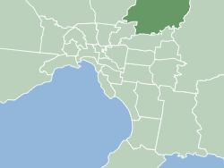 Map of Melbourne showing Shire of Nillumbik | |||||||||||||||
| Population | 62,895 (2021)[1] | ||||||||||||||
| • Density | 145.59/km2 (377.1/sq mi) | ||||||||||||||
| Established | 1994 | ||||||||||||||
| Area | 432 km2 (166.8 sq mi)[1] | ||||||||||||||
| Mayor | Cr Frances Eyre | ||||||||||||||
| Council seat | Greensborough | ||||||||||||||
| Region | Greater Melbourne | ||||||||||||||
| State electorate(s) | |||||||||||||||
| Federal division(s) | |||||||||||||||
| Website | Shire of Nillumbik | ||||||||||||||
| |||||||||||||||
The shire's name is derived from the Parish of Nillumbik, which was named in the 1830s the term nyilum bik meaning "Bad Earth" in the local Aboriginal language Woiwurrung.[4]
On 13 October 1998, Nillumbik Council was suspended by then Local Government minister Rob Maclellan, with the state government declaring that infighting was affecting the ability of the council to function.[5]
Nillumbik was rated third of 590 Australian local government areas in the BankWest Quality of Life Index 2008.[6]
Council
The current council was elected in October 2020 for a four-year term.[7]
| Ward | Party | Councillors | Notes | |
|---|---|---|---|---|
| Blue Lake | Liberal | Richard Stockman | ||
| Bunjil | Liberal | Karen Egan | ||
| Edendale | Independent | Natalie Duffy | ||
| Ellis | Independent | Peter Perkins | ||
| Sugarloaf | Greens | Ben Ramcharan | ||
| Swipers Gully | Independent | Frances Eyre | ||
| Wingrove | Independent | Geoff Paine | ||
Townships and localities
The 2021 census, the shire had a population of 62,895 up from 61,273 in the 2016 census[8]
| Population | ||
|---|---|---|
| Locality | 2016 | 2021 |
| Arthurs Creek | 496 | 478 |
| Bend of Islands | 295 | 267 |
| Christmas Hills | 355 | 365 |
| Cottles Bridge | 601 | 609 |
| Diamond Creek | 11,733 | 12,503 |
| Doreen^ | 21,298 | 27,122 |
| Eltham | 18,314 | 18,847 |
| Eltham North^ | 6,805 | 6,830 |
| Greensborough^ | 20,821 | 21,070 |
| Hurstbridge | 3,450 | 3,554 |
| Kangaroo Ground | 1,095 | 1,208 |
| Kinglake^ | 1,536 | 1,662 |
| Kinglake West^ | 1,166 | 1,305 |
| North Warrandyte | 2,956 | 3,027 |
| Nutfield | 152 | 158 |
| Panton Hill | 1,062 | 1,063 |
| Plenty | 2,364 | 2,575 |
| Research | 2,649 | 2,695 |
| Smiths Gully | 369 | 356 |
| St Andrews | 1,226 | 1,186 |
| Strathewen | 178 | 198 |
| Watsons Creek | 51 | 58 |
| Wattle Glen | 1,961 | 1,911 |
| Yan Yean^ | 252 | 246 |
| Yarrambat | 1,588 | 1,602 |
^ - Territory divided with another LGA
Facilities
Nillumbik's oldest public building is the Eltham courthouse which was restored in 2022.[9]
Eltham Library and Diamond Valley Library located in Greensborough are operated by Yarra Plenty Regional Library A mobile library service is also operated by Yarra Plenty Regional Library serving the locations of Doreen, Panton Hill, St Andrews, Hurstbridge, North Warrandye, Kangaroo Ground, Diamond Creek and Christmas Hills.[10]
Nillumbikk U3A provides a wide range of courses open to all retired and semi-retired people[11]
NillumBUG is a bicycle user group for the Nillumbik Shire.[12]
Books on the Shire of Nillumbik
Marshall, Marguerite, Nillumbik Now and Then Research, Vic. MPrint Publications, 2008 ISBN 9780646491226
See also
References
- "3218.0 – Regional Population Growth, Australia, 2017-18: Population Estimates by Local Government Area (ASGS 2018), 2017 to 2018". Australian Bureau of Statistics. Australian Bureau of Statistics. 27 March 2019. Retrieved 25 October 2019. Estimated resident population, 30 June 2018.
- "Victoria Government Gazette online archive 1836-1997". Victoria Government Gazette S97: 1. 15 December 1994.
- Victoria, Local Government (15 August 2015). "Nillumbik Shire". knowyourcouncil.vic.gov.au. Retrieved 31 May 2021.
- Nillumbik Shire – eMelbourne
- "#33 – The council conundrum". The Age. Fairfax News Store. Retrieved 16 July 2017.
- "BankWest Quality of Life Index 2008" (PDF). BankWest Quality of Life Index 2008. BankWest. 20 August 2008. p. 8. Archived from the original (pdf) on 25 February 2009. Retrieved 3 September 2008.
- "Nillumbik Shire Council election results".
- "Census | Australian Bureau of Statistics". www.abs.gov.au. 11 January 2023.
- "Historic Eltham Courthouse reopens following major restoration". www.nillumbik.vic.gov.au. Retrieved 25 May 2022.
- "Yarra Plenty Regional Library".
- "Nillumbik U3A (University of the Third Age)". nillumbiku3a.org.au. Retrieved 4 June 2021.
- "nillumBUG - Nillumbik Bicycle User Group". nillumBUG - Nillumbik Bicycle User Group. Retrieved 4 June 2021.
External links
 Media related to Shire of Nillumbik at Wikimedia Commons
- Official website
- Public Transport Victoria local public transport map
- Link to Land Victoria interactive maps
- Yarra Plenty Regional Library
- Eltham District Historical Society
- Local Community Wiki
- Living and Learning in Nillumbik
- Community Organisations in Nillumbik and Environs
- Nillumbik Heritage Guide
Localities in the Shire of Nillumbik | ||
|---|---|---|
| City | | |
| Town | ||
| Locality | ||
^ - Territory divided with another LGA | ||