No Name, Colorado
No Name is a census-designated place (CDP) in and governed by Garfield County, Colorado, United States. The CDP is a part of the Glenwood Springs, CO Micropolitan Statistical Area. The population of the No Name CDP was 117 at the United States Census 2020.[3] The Glenwood Springs post office (Zip Code 81601) serves the area.[4]
No Name, Colorado | |
|---|---|
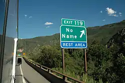 Sign at Exit 119 of Interstate 70 | |
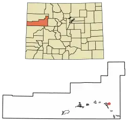 Location of the No Name CDP in Garfield County, Colorado. | |
 No Name Location of the No Name CDP in the United States. | |
| Coordinates: 39°33′35″N 107°17′34″W[1] | |
| Country | |
| State | |
| County | Garfield County |
| Government | |
| • Type | unincorporated community |
| Area | |
| • Total | 0.179 sq mi (0.463 km2) |
| • Land | 0.179 sq mi (0.463 km2) |
| • Water | 0.000 sq mi (0.000 km2) |
| Elevation | 5,869 ft (1,789 m) |
| Population | |
| • Total | 117 |
| • Density | 650/sq mi (250/km2) |
| Time zone | UTC-7 (MST) |
| • Summer (DST) | UTC-6 (MDT) |
| ZIP Code[4] | Glenwood Springs 81601 |
| Area code | 970 |
| GNIS feature[2] | No Name CDP |
Geography
No Name is located east of Glenwood Springs, off Exit 119 of Interstate 70/U.S. Route 6 (I-70/US 6) in Glenwood Canyon. It is named for No Name Creek and No Name Canyon. The No-Name was one of the boats on John Wesley Powell's expedition in 1869 to map out the Colorado River along with the other boats including the Emma Dean, Kitty Clyde's sister, and Maid of the Canyon. The No Name Tunnel of I-70/US 6 is nearby. It has frequently been noted on lists of unusual place names.[5]
The exit sign for No Name is visible in passing in the 1971 film Vanishing Point.
The No Name CDP has an area of 114 acres (0.463 km2), all land.[1]
Demographics
| Year | Pop. | ±% |
|---|---|---|
| 2010 | 123 | — |
| 2020 | 117 | −4.9% |
| Source: United States Census Bureau | ||
The United States Census Bureau initially defined the No Name CDP for the United States Census 2010.
References
- "State of Colorado Census Designated Places - BAS20 - Data as of January 1, 2020". United States Census Bureau. Retrieved December 22, 2020.
- "U.S. Board on Geographic Names: Domestic Names". United States Geological Survey. Retrieved December 19, 2020.
- United States Census Bureau. "No Name CDP, Colorado". Retrieved April 16, 2023.
- "Zip Code 81601 Map and Profile". zipdatamaps.com. 2020. Retrieved December 22, 2020.
- Parker, Quentin (July 18, 2010). Welcome to Horneytown, North Carolina, Population: 15: An insider's guide to 201 of the world's weirdest and wildest places. Adams Media. p. xi. ISBN 9781440507397.
External links
Municipalities and communities of Garfield County, Colorado, United States | ||
|---|---|---|
| Cities |  Map of Colorado highlighting Garfield County | |
| Towns | ||
| CDPs | ||
| Unincorporated communities | ||
| Ghost town | ||