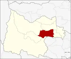
Nong Chang district
Nong Chang (Thai: หนองฉาง, pronounced [nɔ̌ːŋ t͡ɕʰǎːŋ]) is a district (amphoe) of Uthai Thani province, northern Thailand.
Nong Chang
หนองฉาง | |
|---|---|
 District location in Uthai Thani province | |
| Coordinates: 15°23′29″N 99°50′29″E | |
| Country | Thailand |
| Province | Uthai Thani |
| Seat | Nong Chang |
| Area | |
| • Total | 341.2 km2 (131.7 sq mi) |
| Population (2008) | |
| • Total | 44,366 |
| • Density | 131.4/km2 (340/sq mi) |
| Time zone | UTC+7 (ICT) |
| Postal code | 61110 |
| Geocode | 6104 |
Geography
Neighboring districts are (from the southwest clockwise) Huai Khot, Lan Sak, Thap Than, Nong Khayang of Uthai Thani Province and Nong Mamong of Chai Nat province.
History
In 1917 the district was renamed from Uthai Kao (อุทัยเก่า) to Nong Chang.[1]
Administration
The district is divided into 10 sub-districts (tambons), which are further subdivided into 96 villages (mubans). There are two sub-district municipalities (thesaban tambon) in the district: Khao Bang Kraek covers tambon Khao Bang Kraek, and Nong Chang covers parts of tambon Nong Chang and Nong Suang.
| No. | Name | Thai | Villages | Pop.[2] |
|---|---|---|---|---|
| 1. | Nong Chang | หนองฉาง | 7 | 5,173 |
| 2. | Nong Yang | หนองยาง | 10 | 5,588 |
| 3. | Nong Nang Nuan | หนองนางนวล | 10 | 3,129 |
| 4. | Nong Suang | หนองสรวง | 5 | 2,616 |
| 5. | Ban Kao | บ้านเก่า | 9 | 1,405 |
| 6. | Uthai Kao | อุทัยเก่า | 10 | 2,487 |
| 7. | Thung Pho | ทุ่งโพ | 15 | 7,973 |
| 8. | Thung Phong | ทุ่งพง | 11 | 2,156 |
| 9. | Khao Bang Kraek | เขาบางแกรก | 7 | 6,556 |
| 10. | Khao Kwang Thong | เขากวางทอง | 12 | 7,283 |
References
- ประกาศกระทรวงมหาดไทย เรื่อง เปลี่ยนชื่ออำเภอ (PDF). Royal Gazette (in Thai). 34 (ก): 40–68. 29 April 1917. Archived from the original (PDF) on 7 November 2011.
- "Population statistics 2008". Department of Provincial Administration. Archived from the original on 20 August 2009. Retrieved 5 November 2009.
External links
- (in Thai) amphoe.com
This article is issued from Wikipedia. The text is licensed under Creative Commons - Attribution - Sharealike. Additional terms may apply for the media files.