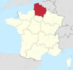
Hauts-de-France
Hauts-de-France (French pronunciation: [o də fʁɑ̃s] ⓘ; lit. 'Heights of France', also Upper France[2], Picard: Heuts d'Franche) is the northernmost region of France, created by the territorial reform of French regions in 2014, from a merger of Nord-Pas-de-Calais and Picardy. Its prefecture is Lille. The new region came into existence on 1 January 2016, after regional elections in December 2015.[3] The Conseil d'État approved Hauts-de-France as the name of the region on 28 September 2016, effective the following 30 September.[4][5]
Hauts-de-France
| |
|---|---|
 Grand Place in Lille | |
 Flag  Coat of arms | |
 | |
| Coordinates: 49.9206°N 2.7030°E | |
| Country | |
| Prefecture | Lille |
| Departments | |
| Government | |
| • President of the Regional Council | Xavier Bertrand (LR) |
| Area | |
| • Total | 31,813 km2 (12,283 sq mi) |
| • Rank | 9th |
| Population | |
| • Total | 5,997,734 |
| • Density | 190/km2 (490/sq mi) |
| Time zone | UTC+01:00 (CET) |
| • Summer (DST) | UTC+02:00 (CEST) |
| ISO 3166 code | FR-HDF |
| GDP (PPP) (2016) | Ranked 5th (13th per capita) |
| Total | €176 billion (US$195 billion) |
| Per capita | €29,215 (US$32,363) |
| NUTS Region | FRE |
| Website | www |
With 6,009,976 inhabitants as of 1 January 2015 and a population density of 189 inhabitants per km2, it is the third most populous region in France and the second-most densely populated in metropolitan France after its southern neighbour Île-de-France. It is bordered by Belgium to the north. The region is a blend mixture of French and (southern-) Dutch cultures.
Toponymy
The region's interim name Nord-Pas-de-Calais-Picardie was a hyphenated placename, created by hyphenating the merged regions' names—Nord-Pas-de-Calais and Picardie—in alphabetical order.[6]
On 14 March 2016, well ahead of the 1 July deadline, the regional council decided on Hauts-de-France as the region's permanent name.[4][6] The provisional name of the region was retired on 30 September 2016, when the new name of the region, Hauts-de-France, took effect.[5]
Geography
The region covers an area of more than 31,813 km2 (12,283 sq mi). It borders Belgium (Flanders and Wallonia) to the northeast, the North Sea to the north, the English Channel to the west, as well as the French regions of Grand Est to the east-southeast, Île-de-France to the south, and Normandy to the west-southwest. It is connected to the United Kingdom (England) via the Channel Tunnel.
Departments
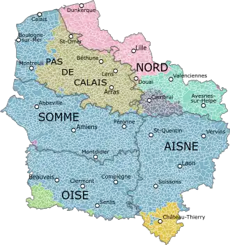
Hauts-de-France comprises five departments: Aisne, Nord, Oise, Pas-de-Calais, and Somme.
Major communities
- Lille (227,560; region prefecture; surrounding area is home to over 1.5 million inhabitants)
- Amiens (133,448)
- Roubaix (94,713)
- Tourcoing (91,923)
- Dunkirk (90,995)
- Calais (72,589)
- Villeneuve-d'Ascq (62,308)
- Saint-Quentin (55,978)
- Beauvais (54,289)
- Valenciennes (42,691)
 Notre Dame de Laon, France
.JPG.webp)

Economy
The gross domestic product (GDP) of the region was 161.7 billion euros in 2018, accounting for 6.9% of French economic output. GDP per capita adjusted for purchasing power was 24,200 euros or 80% of the EU27 average in the same year. The GDP per employee was 101% of the EU average.[7]
Linen weaving
The region was a pivotal centre of mulquinerie.
See also
References
- "Téléchargement du fichier d'ensemble des populations légales en 2020". The National Institute of Statistics and Economic Studies. 29 December 2022.
- "The North: Upper France". francerevisited.com.
- "La carte à 13 régions définitivement adoptée" [The 13-region map finally adopted]. Le Monde (in French). Agence France-Presse. 17 December 2014. Retrieved 13 January 2015.
- "La Région a voté et s'appelle désormais Hauts-de-France" [The region has voted and is now called Hauts-de-France]. La Voix du Nord (in French). Lille. 15 March 2016. Retrieved 15 March 2016.
- Décret n° 2016-1265 du 28 septembre 2016 portant fixation du nom et du chef-lieu de la région Hauts-de-France (in French)
- Loi n° 2015–29 du 16 janvier 2015 relative à la délimitation des régions, aux élections régionales et départementales et modifiant le calendrier électoral (in French)
- "Regional GDP per capita ranged from 30% to 263% of the EU average in 2018". Eurostat.
External links
- Official website
 (in French)
 - Merger of the regions – France 3 Archived 2015-06-16 at the Wayback Machine