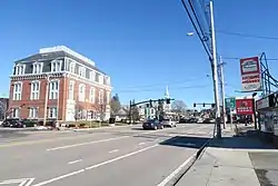
Northborough (CDP), Massachusetts
Northborough is a census-designated place (CDP) in the town of Northborough in Worcester County, Massachusetts, United States. The population was 6,474 at the 2020 United States census.[2]
Northborough, Massachusetts | |
|---|---|
 Main Street | |
_highlighted.svg.png.webp) Location in Worcester County and the state of Massachusetts. | |
| Coordinates: 42°18′43″N 71°38′54″W | |
| Country | United States |
| State | Massachusetts |
| County | Worcester |
| Area | |
| • Total | 3.31 sq mi (8.58 km2) |
| • Land | 3.29 sq mi (8.51 km2) |
| • Water | 0.03 sq mi (0.07 km2) |
| Elevation | 302 ft (92 m) |
| Population (2020) | |
| • Total | 6,474 |
| • Density | 1,970.78/sq mi (761.02/km2) |
| Time zone | UTC-5 (Eastern (EST)) |
| • Summer (DST) | UTC-4 (EDT) |
| ZIP code | 01532 |
| Area code | 508 |
| FIPS code | 25-46785 |
| GNIS feature ID | 0610881 |
Geography
According to the United States Census Bureau, the CDP has a total area of 8.6 km2 (3.3 mi2). 8.6 km2 (3.3 mi2) of it is land and 0.30% is water.[3] Its population per square mile is 1,970.8 as of 2020.[2]
Demographics
| Census | Pop. | Note | %± |
|---|---|---|---|
| 2020 | 6,474 | — | |
| U.S. Decennial Census[4] | |||
At the 2020 census, there were 6,474 people and 2,514 households in the CDP.[2] The racial makeup of the CDP was 84.1% White, 1.5% Black or African American, 0.0% Native American, 7.5% Asian, 0.0% Pacific Islander, and 5.1% from two or more races. Hispanic or Latino of any race were 5.5%.[5]
The age distribution was 4.2% people under the age of 5, 21.5% under 18, 15.7% aged 65 and over, and 54% females.
The median household income in 2021 was $140, 482.[2] The per capita income for the CDP was $74,924. About 2.4% of the people were in poverty.
References
- "2020 U.S. Gazetteer Files". United States Census Bureau. Retrieved May 21, 2022.
- "Northborough CDP, Massachusetts".
- "US Gazetteer files: 2010, 2000, and 1990". United States Census Bureau. February 12, 2011. Retrieved April 23, 2011.
- "Census of Population and Housing". Census.gov. Retrieved June 4, 2016.
- "U.S. Census website". United States Census Bureau. Retrieved January 31, 2008.
