Nostie
Nostie (Scottish Gaelic: Ceann na Mòna) is a small remote hamlet, lying on Nostie Bay, an inlet at the northeastern end of the sea loch, Loch Alsh in the Scottish Highlands and is in the council area of Highland. Nostie lies a short distance from one of Scotland's popular tourist attractions, Eilean Donan Castle.
Nostie
| |
|---|---|
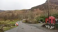 The road through Nostie, looking towards the A87 junction | |
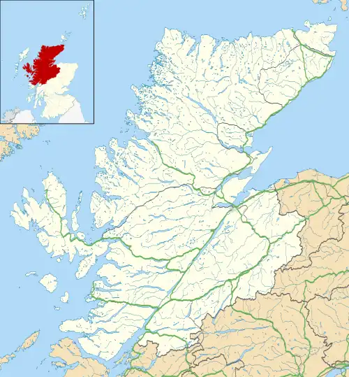 Nostie Location within the Highland council area | |
| OS grid reference | NG860270 |
| Council area | |
| Country | Scotland |
| Sovereign state | United Kingdom |
| Post town | Kyle of Lochalsh |
| Postcode district | IV40 8 |
| Police | Scotland |
| Fire | Scottish |
| Ambulance | Scottish |
Notable residents
It is the home of the well known young Scottish harpist, Murdo Macrae. He was born there, the second son of Farquar Macrae, a hill farmer and Susie Macrae, a dentist, both of whom were musical. He began to play the piano when he was five, and discovered the harp at Plockton primary school when he was nine. After finishing his schooling at Sleat on the Isle of Skye and at Plockton High School, he went to the City of Edinburgh Music School, and subsequently began a post graduate course at Brooklyn College in New York.[1]
Nostie was also the home village of the late Reverend Kenneth MacLeod.[2]
Hydro-electricity
The politician Tom Johnston during his time as Secretary of State for Scotland,[3] championed the Hydro-electric Development (Scotland) Act 1943, which created the North of Scotland Hydro-Electric Board.[4] Johnston's vision was for a public body that could build hydro-electric stations throughout the Highlands. Profits made by selling bulk electricity to the Scottish lowlands would be used to fund "the economic development and social improvement of the North of Scotland." Private consumers would be offered a supply of cheap electricity, and their connection to that supply would not reflect the actual cost of its provision in remote and sparsely-populated areas.[5]
The chairman of the new Board was to be Lord Airlie, who had initially been critical of the 1943 Act because its scope was too limited. The deputy chairman and chief executive was Edward MacColl, an engineer with wide experience of hydro-electric projects and electrical distribution networks.[6] It soon became clear that MacColl intended to push ahead with the aspirations of the Act at breakneck speeds. He produced a list of 102 potential sites in just three months,[7] and in June 1944, the first constructional scheme was published. This was for the Loch Sloy scheme, which had a ready market for bulk supplies to nearby Clydeside, but it included two smaller schemes, to demonstrate the Board's committment to supplying remote areas. These were at Morar and Kyle of Lochalsh. The estimated cost of the two smaller schemes was £0.5 million, compared to £4.1 million for the Sloy development. Implementation was delayed, because although there were no objections to the two smaller schemes, there was vigorous opposition to the Sloy scheme, and a public inquiry was held to consider the objections.[8] John Cameron KC decided that the objectors had failed to convince him that the scheme was not in the public interest, and the three schemes were authorised on 28 March 1945.[9]
The Lochalsh scheme would be built at Nostie Bridge, where the A87 road crosses the Allt Gleann Udalain, just to the west of the hamlet,[10] by the engineers Sir William Halcrow and Partners.[11] Construction began after a pole raising ceremony was held at the power station site in May 1946. The original plan was to build two dams, but the geology proved unsuitable, and a single dam was built.[12] The installed capacity was 1.25 MW.[13]

James Shearer was one of three members of the Panel of Architectural Advisors to the Board,[14] and he was asked to carry out the architectural work for the Lochalsh scheme. The civil engineers stated that they wanted a rectangular brick building with a slate roof. Shearer visited the site, and noted that all of the buildings in the area were built of local stone, in a style which he called cottage architecture.[15] He began to wonder whether it would be possible to use stone for the power station, despite the fact that building with stone was a dying art. With some trepidation, he approached MacColl to discuss his proposal, and found that MacColl was in complete agreement with the concept. He asked Shearer to produce a list of sources for the material, and to find contractors who could muster enough quarrymen and masons to ensure the success of the idea.[16] Implementation was not without its difficulties, but these were gradually overcome, and the Lochalsh Power Station at Nostie was completed in 1948. It was officially opened on 21 December by Miss Macrae from Conchra, with Tom Johnston overseeing the proceedings. The smaller station at Morar was designed by Reginald Fairlie, another member of the Panel of Architectural Advisors. It was also built of stone and opened on the same day.[17] The decision to use stone informed most of the projects undertaken by the North of Scotland Hydro-Electric Board subsequently. Smaller buildings were built of stone, while larger ones were clad with it.[18]
Infrastructure
Nostie Bridge hydro-electric scheme | ||||||||||||||||||||||||||||||||||||||||||||||||||||||||||||||||||||||||||||||||||||||||||||||||||||||||||||||||||||||||||||||||||||||||||||
|---|---|---|---|---|---|---|---|---|---|---|---|---|---|---|---|---|---|---|---|---|---|---|---|---|---|---|---|---|---|---|---|---|---|---|---|---|---|---|---|---|---|---|---|---|---|---|---|---|---|---|---|---|---|---|---|---|---|---|---|---|---|---|---|---|---|---|---|---|---|---|---|---|---|---|---|---|---|---|---|---|---|---|---|---|---|---|---|---|---|---|---|---|---|---|---|---|---|---|---|---|---|---|---|---|---|---|---|---|---|---|---|---|---|---|---|---|---|---|---|---|---|---|---|---|---|---|---|---|---|---|---|---|---|---|---|---|---|---|---|---|
| ||||||||||||||||||||||||||||||||||||||||||||||||||||||||||||||||||||||||||||||||||||||||||||||||||||||||||||||||||||||||||||||||||||||||||||
A reservoir for the power station was formed by constructing a dam across Gleann Udalain. This is a mass gravity structure, with the top of the dam forming the spillway for most of its width. A walkway is carried over the dam supported by a continuous row of arches.[19] The reservoir is known as Lochalsh Dam, covers an area of 30 acres (12 ha), and its surface level is 502 feet (153 m) above ordnance datum (AOD). Its catchment area is 5,080 acres (2,056 ha),[20] with most of the water flowing into it from the Allt Gleann Udalain, but this is fed by an extensive network of tributary streams stretching to the north east, which drain the land between Loch Carron to the north-west and Loch Long to the south-east.[21]
Just below the dam is a weir, where a valve house routes most of the water discharged from the dam into a steel pipeline.[19] This is initially 33 inches (840 mm) in diameter, and is encased in concrete. It follows the contours of the valley, and is reinforced whenever the route changes direction.[22] Further down, it changes to twin 24-inch (610 mm) pipelines, and only the joins where it changes direction are encased in concrete.[23] It runs on the surface, broadly parallel to the Allt Gleann Udalain, to a point just to the north of the A87 road. The final small section to Nostie Bridge power station, which is immediately to the south of the road, runs underground.[21] The outflow from the station rejoins the river a short distance to the south-east, which flows over a weir and is crossed by a bridge carrying the road through Nostie.[21] In the early 20th century, there was a footbridge, a ford and stepping stones at this point.[24] The bridge forms the highest point to which tides flow, and the river then enters Nostie Bay and Loch Alsh.[21]
In 1955, there was a severe drought in the Highlands, and water levels in Lochalsh Dam dropped sufficiently that reductions in the amount of power produced seemed likely. In order to resolve the problem, workers constructed nearly 1 mile (1.6 km) of channel to enable water from Loch na Smeòraich to supplement the supply in Lochalsh Dam. The work was carried out using hand tools.[25]
References
- "The Scottish Invasion of Brooklyn College". Archived from the original on 14 July 2022.
- "Kenny "Nostie" MacLeod, Thurso". Shinty.com. 25 April 2012. Archived from the original on 13 May 2014.
- Miller 2002, pp. 19–20.
- Payne 1988, pp. 50, 298.
- Wood 2002, pp. 58–59.
- Payne 1988, pp. 50–51.
- Payne 1988, p. 55.
- Payne 1988, pp. 60–61.
- Payne 1988, p. 63.
- Ordnance Survey, 1:25000 map
- "Nostie Bridge Power Station". Canmore. Archived from the original on 7 June 2023.
- "Nostie Bridge Power Station". Am Baile - Highland History and Culture. Archived from the original on 7 June 2023.
- Payne 1988, Frontpiece.
- Payne 1988, p. 54.
- Fraser 1956, p. 39.
- Fraser 1956, p. 40.
- Fraser 1956, pp. 40–41.
- Wood 2002, p. 81.
- "Lochalsh Dam". Canmore. Archived from the original on 7 June 2023.
- "Lochalsh Dam Water body ID 19472". UK Centre for Ecology and Hydrology.
- Ordnance Survey, 1:25000 map
- "Lochalsh Hydro-Electric Pipeline". Am Baile - Highland History and Culture. Archived from the original on 12 June 2023.
- "Lochalsh Hydro-Electric Pipeline". Am Baile - Highland History and Culture. Archived from the original on 12 June 2023.
- Ordnance Survey, 6 inch map, 1888-1913
- "Nostie Bridge Hydro-Electric Scheme". Am Baile - Highland History and Culture. Archived from the original on 7 June 2023.
Bibliography
- Fraser, Norrie, ed. (1956). Sir Edward MacColl - A maker of modern Scotland. Edinburgh: Stanley Press.
- Miller, James (2002). The Dam Builders - Power from the Glens. Birlinn. ISBN 978-1-84158-225-2.
- Payne, Peter L (1988). The Hydro. Aberdeen University Press. ISBN 978-0-08-036584-8.
- Wood, Emma (2002). The Hydro Boys. Luath Press. ISBN 978-1-84282-016-2.
External links
![]() Media related to Nostie at Wikimedia Commons
Media related to Nostie at Wikimedia Commons
- "Collection of historical pictures showing construction of the dam, pipeline and power station". Am Baile - Highland History and Culture.
| Sectors | |||||||||||||
|---|---|---|---|---|---|---|---|---|---|---|---|---|---|
| Companies & organisations |
| ||||||||||||
| Active power stations |
| ||||||||||||
| Deactivated stations |
| ||||||||||||
| Other | |||||||||||||
| |||||||||||||