Oak Hill-Piney, Oklahoma
Oak Hill-Piney is a census-designated place (CDP) in Delaware County, Oklahoma, United States. It was first listed as a CDP prior to the 2020 census.
Oak Hill-Piney, Oklahoma | |
|---|---|
 Oak Hill-Piney  Oak Hill-Piney | |
| Coordinates: 36°22′43″N 94°43′36″W[1] | |
| Country | United States |
| State | Oklahoma |
| County | Delaware |
| Area | |
| • Total | 2.66 sq mi (6.90 km2) |
| • Land | 2.66 sq mi (6.90 km2) |
| • Water | 0.00 sq mi (0.00 km2) |
| Elevation | 974 ft (297 m) |
| Population (2020) | |
| • Total | 191 |
| • Density | 71.72/sq mi (27.69/km2) |
| Time zone | UTC-6 (Central (CST)) |
| • Summer (DST) | UTC-5 (CDT) |
| ZIP Code | 74346 (Jay) |
| Area code(s) | 918/539 |
| FIPS code | 40-53301 |
| GNIS feature ID | 2807039[1] |
The CDP is in east-central Delaware County. It is bordered to the north by the Sycamore CDP, and it is 6 miles (10 km) southeast of Jay, the county seat. The southern border of Oak Hill-Piney is Beaty Creek, a west-flowing tributary of Spavinaw Creek flowing into Lake Eucha and part of the Neosho River watershed.
References
- U.S. Geological Survey Geographic Names Information System: Oak Hill-Piney, Oklahoma
- "ArcGIS REST Services Directory". United States Census Bureau. Retrieved September 20, 2022.
- "Census of Population and Housing". Census.gov. Retrieved June 4, 2016.
Municipalities and communities of Delaware County, Oklahoma, United States | ||
|---|---|---|
| Cities | 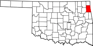 Delaware County map | |
| Towns | ||
| CDPs | ||
| Other communities | ||
| Indian reservation | ||
| Footnotes | ‡This populated place also has portions in an adjacent county or counties | |
This article is issued from Wikipedia. The text is licensed under Creative Commons - Attribution - Sharealike. Additional terms may apply for the media files.